
Ground Equipment Facility J-31 facts for kids
Quick facts for kids San Pedro Hill Air Force Station |
|
|---|---|
| Part of 1961-1968: 1968-1979: |
|
| San Pedro Hill, Rancho Palos Verdes, California (highest elevation of the Palos Verdes Hills) |
|

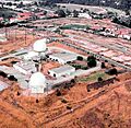
San Pedro Hill AFS in 1988.
|
|
| Coordinates | 33°44′46″N 118°20′10″W / 33.74611°N 118.33611°W 1.2 miles (1.9 km) southeast of Rolling Hills |
| Type | USAF General Surveillance Radar Station |
| Code | RP-39: 1950 ADC permanent network Z-39: 1963 July 31 NORAD network J-31: 1983 Joint Surveillance System |
| Site information | |
| Controlled by | 1960-79: USAF 670th Radar Squadron 1979-97: Federal Aviation Administration |
| Condition | radar site of Los Angeles ARTCC |
| Site history | |
| In use | 1960-1979 |
The Ground Equipment Facility J-31 is a special radar site. It was known as San Pedro Hill Air Force Station during the Cold War. The Cold War was a time of tension between the United States and the Soviet Union.
This site is part of the Joint Surveillance System. This system helps the Western Air Defense Sector (WADS) keep an eye on the skies. It also helps the Federal Aviation Administration (FAA) manage air traffic. The FAA is the agency that controls flights in the United States.
The radar at San Pedro Hill is called an Air Route Surveillance Radar. It also has a special system that gets more information from planes. These systems help guide planes safely. The data from this site is also sent to North American Aerospace Defense Command (NORAD). NORAD is a joint command that protects the airspace of North America.
In the past, this site helped with the Semi-Automatic Ground Environment (SAGE) system. SAGE was an early computer system used to defend against air attacks. It also helped with Project Nike, which was a missile defense system.
Contents
History of San Pedro Hill Air Force Station
The San Pedro Hill radar station started working in 1961. It was a joint project between the Air Force and the FAA. The 670th Radar Squadron moved to this site on April 1, 1961. This squadron was in charge of operating the radars.
Radar Technology and Upgrades
The station used different types of radar. These included radars that could find the height of planes. In 1964, a new radar was added, but it was removed a few years later. Some of the older radars were also updated to newer versions.
In 1976, the squadron changed its name. Around this time, one of the height-finding radars was removed.
Transfer to Civilian Control
The military planned to transfer the radar station to civilian control. This happened after 1978. The station was given to the FAA when the Aerospace Defense Command was closed down. Even after the transfer, the Air Force continued to use one of the height-finding radars until about 1988.
Later, in the 1990s, the Air Force stopped getting data directly from San Pedro Hill. Instead, they started getting data from a newer radar located on San Clemente Island. However, the main radar at San Pedro Hill was still in use by 2010.
Images for kids
-
San Pedro Hill AFS in 1988.
