Guadalmedina facts for kids
Quick facts for kids Guadalmedina |
|
|---|---|

The Guadalmedina in Málaga
|
|

Course of the Guadalmedina
|
|
| Country | Spain |
| Physical characteristics | |
| Main source | Sierra de Camarolos, Andalusia |
| River mouth | Mediterranean Sea 0 m (0 ft) 36°42′23″N 4°25′33″W / 36.70639°N 4.42583°W |
| Length | 47 kilometres (29 mi) |
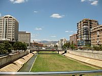
The Guadalmedina is a river in Spain. It flows right through the city of Málaga. Its name comes from Arabic words meaning 'river of the city'. This river has been very important to Málaga for a long time. It even divides the city into two parts. The oldest part of Málaga is on the river's left side.
Where the Guadalmedina Flows
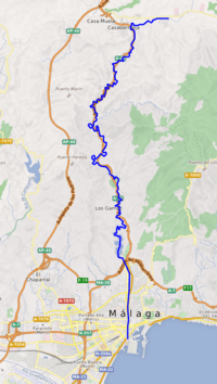
The Guadalmedina river starts high up in the mountains. Its source is at La Cruz Peak. This peak is part of the Sierra de Camarolos mountain range. The river is about 47 kilometers (29 miles) long.
The river ends in the Mediterranean Sea. It reaches the sea right in the center of Málaga city. Along its path, the Guadalmedina flows through the Montes de Málaga Natural Park. This park is a beautiful natural area.
River Branches and Water Supply
The amount of water in the Guadalmedina changes a lot. It depends on the season. The river has five smaller streams that flow into it. These are called tributaries. They are the Arroyo de las Vacas, Arroyo Chaperas, Arroyo Humaina, Arroyo Hondo, and Arroyo de Los Frailes. All these streams start in the Montes de Málaga mountains. Most of the year, these smaller rivers are dry.
The Limonero Dam is built on the Guadalmedina river. This dam helps to store water. It provides water for the people and area around Málaga.
See also
 In Spanish: Guadalmedina para niños
 | Delilah Pierce |
 | Gordon Parks |
 | Augusta Savage |
 | Charles Ethan Porter |

