Gulf of Urabá facts for kids
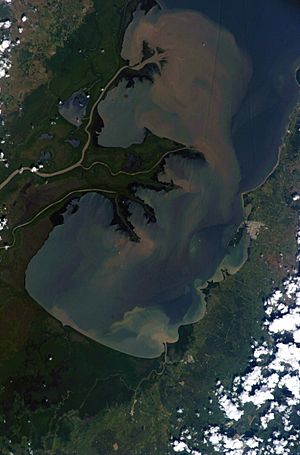
The Gulf of Urabá is a large bay on the northern coast of Colombia. It is part of the Caribbean Sea. This long, wide body of water is like an arm of the sea reaching into the land. It is located very close to where the continent of South America connects to the narrow strip of land called the Isthmus of Panama.
The town of Turbo, Colombia, is found on the eastern side of the Gulf. It is naturally protected by Turbo Bay, which is part of the larger Gulf. The Atrato River, one of Colombia's major rivers, flows into the Gulf of Urabá.
Contents
What is the Gulf of Urabá?
The Gulf of Urabá is a significant natural feature in Colombia. It acts as a natural harbor and is important for trade and transportation. Its waters are home to various marine life. The gulf's location makes it a key point for connecting different parts of the region.
Location and Geography
The Gulf of Urabá stretches about 80 kilometers (50 miles) from north to south. It is about 25 kilometers (15 miles) wide at its widest point. The gulf is surrounded by lush tropical forests and wetlands. These areas are fed by several rivers, with the Atrato River being the largest.
The land around the gulf is mostly flat. It is made up of floodplains and deltas formed by the rivers. This flat land is often used for farming. The climate here is tropical, meaning it is warm and humid all year round.
Connecting Continents: The Pan-American Highway Idea
The Gulf of Urabá has been considered as a possible end point for a famous road project. This project is the Pan-American Highway. This highway is a network of roads that connects almost all the countries in North and South America.
The Darién Gap Challenge
There is a section of the Pan-American Highway that is not yet built. This missing part is called the Darién Gap. It is a dense jungle and swamp area that is very hard to cross. It is about 87 kilometers (54 miles) long. Building a road through this area is very difficult and expensive. It also raises concerns about the environment and local communities.
A Ferry Link Idea
A group called Bio-Pacifico suggested a different idea. Instead of building a road through the Darién Gap, they proposed extending the highway in Panama to the Caribbean coast. This road would end at the Gulf of Urabá. From there, cars and trucks could use a ferry to cross the gulf. The ferry would connect to existing highways in Colombia. This idea could help complete the highway link without building through the difficult jungle.
Urabá Antioquia Subregion
The area around the Gulf of Urabá is very important to Colombia. It forms a special region known as Urabá Antioquia. This is a geopolitical subregion of the Antioquia Department.
Importance of the Region
The Urabá Antioquia subregion is known for its rich agriculture. It is a major producer of bananas and plantains. These crops are often exported to other countries. The region also has important ports that help with trade.
The area is also culturally diverse. Many different groups of people live here, including indigenous communities and Afro-Colombian communities. This mix of cultures makes the region unique and vibrant.
See also
 In Spanish: Golfo de Urabá para niños
 | Claudette Colvin |
 | Myrlie Evers-Williams |
 | Alberta Odell Jones |


