Darién Gap facts for kids
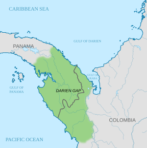
The Darién Gap is a wild and challenging area of forests, mountains, and swamps. It's located in Central America, connecting Panama and Colombia. This region is famous because it's the only place where the huge Pan-American Highway is broken.
The Darién Gap is about 106 kilometers (66 miles) long. It's too difficult and expensive to build a road through it. Building a road here would also harm the environment. So, as of 2023, there are no plans to build a highway through this unique area.
On the Colombian side, the land is mostly flat and marshy, created by the Atrato River. On the Panamanian side, it's a mountainous rainforest. Some peaks reach up to 1,845 meters (6,053 feet) high.
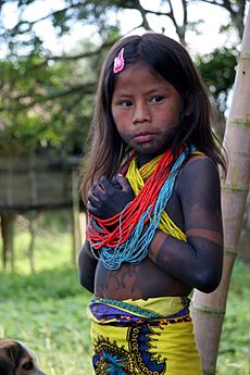
The Darién Gap is home to indigenous groups like the Embera-Wounaan and Guna people. They often travel by pirogue, which is a type of canoe. La Palma is an important town in the area. Local farms grow foods like maize (corn), cassava, and bananas.
There are no roads across the Darién Gap. You can travel around it by boat. Some people try to hike through it, but it's very hard and dangerous. Heavy rain and sudden floods are common. There's no police or medical help. Many migrants have crossed the Gap on foot since the 2010s, trying to reach the Mexico–United States border.
Contents
The Pan-American Highway Break
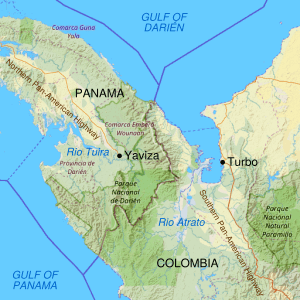
The Pan-American Highway is a massive road system. It stretches for about 30,000 kilometers (19,000 miles) across North, Central, and South America. The only part that's missing is the 106-kilometer (66-mile) stretch through the Darién Gap.
On the South American side, the highway ends near Turbo, Colombia. On the Panamanian side, it ends in the town of Yaviza.
Why the Highway Isn't Built
Many people and groups, including the local indigenous communities, don't want the highway completed. They have several reasons:
- To protect the valuable rainforest.
- To stop the spread of tropical diseases.
- To protect the way of life of the indigenous people.
- To prevent animal diseases, like foot-and-mouth disease, from spreading into North America.
Building the highway up to Yaviza caused a lot of deforestation (cutting down trees) nearby.
Past Attempts to Build the Road
Plans to build the road started in 1971 with help from the United States. But these plans stopped in 1974 because environmental groups were worried. The U.S. government also blocked support in 1978 to prevent the spread of foot-and-mouth disease.
Another attempt to build the road began in 1992. But by 1994, the United Nations said that the road would cause huge environmental damage. The Darién Gap has actually helped stop the spread of diseased cattle into Central and North America.
The Embera-Wounaan and Guna people are among the groups who worry that a road would harm their cultures. It could destroy their food sources and change their way of life.
Other Travel Ideas
Instead of a road, some people have suggested a ferry service. This would connect ports in Colombia (like Turbo) with ports in Panama. Some ferry services have tried this before, but they weren't profitable and closed down. As of 2023, this idea hasn't moved forward.
Another idea is to build a mix of bridges and tunnels. This would avoid the most sensitive natural areas.
History of the Darién Gap
Early History
Not as much archaeological study has been done in the Darién Gap compared to other areas. But researchers have found many ancient sites. These sites include large mounds, plazas, paved roads, and stone sculptures. They also found items made from jade, gold, and ceramic.
The Guna people lived in what is now northern Colombia and Panama when the Spanish arrived. They later moved westward to avoid conflicts with the Spanish and other groups.
European Arrivals
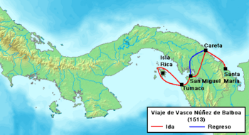
In the early 1500s, explorers like Vasco Núñez de Balboa and Alonso de Ojeda explored the coast of Colombia. Balboa heard about a "South Sea" (the Pacific Ocean) from local people. He saw the Pacific Ocean on September 25, 1513.
In 1519, the town of Panamá was founded on the Pacific coast. It became an important port for shipping goods and an administrative center. Later, in 1671, the pirate Henry Morgan attacked and destroyed the city. The town was then rebuilt a few kilometers away. The ruins of the old city, Panamá Viejo, are now a UNESCO World Heritage Site.
Silver and gold from Peru were transported across the isthmus to Porto Bello. From there, Spanish ships carried the treasures to Spain.
The Darién Scheme
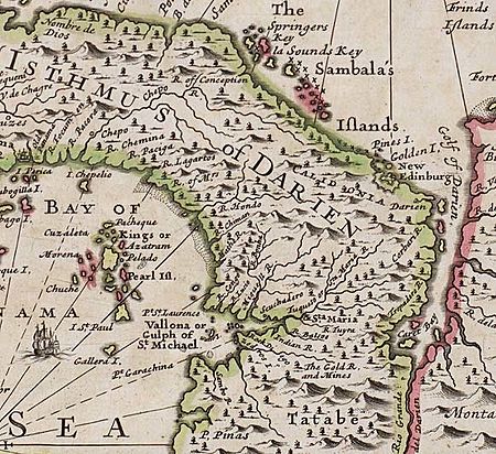
In 1698, the Kingdom of Scotland tried to start a settlement in the Darién Gap. This project was called the Darién scheme. The Scots hoped to create a trade route between the Atlantic and Pacific oceans. This was similar to what the Panama Canal later achieved.
The first expedition had five ships and about 1,200 people. They landed in Darién on November 2, 1698, and named their new home "New Caledonia."
However, the colony faced many problems. There was poor planning, bad supplies, and diseases. The Spanish Empire also attacked them. The settlement was finally abandoned in March 1700.
The failure of the Darién scheme was a huge financial disaster for Scotland. It's believed that this failure helped convince Scotland to unite with England in 1707.
Panamanian Independence
Most of Panama was part of Colombia until 1903. That year, Panama declared its independence. The United States supported this move. The difficult geography of the Darién Gap made it hard for Colombia to control and defend the region.
The current border between Colombia and Panama was set by a treaty signed in 1924.
Natural Resources
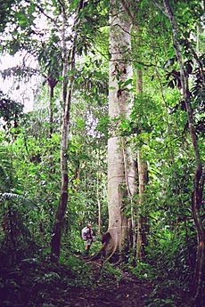
The Darién Gap has two major national parks: Darién National Park in Panama and Los Katíos National Park in Colombia. These forests once had many valuable trees like cedrela and mahogany. Many of these trees have been cut down by loggers.
Darién National Park in Panama is the largest national park in Central America. It covers about 5,790 square kilometers (2,236 square miles) and was created in 1980.
Crossing the Darién Gap Today
Many video teams have traveled with migrants through the Darién Gap. This has helped people understand the difficult conditions of the route. It is possible to cross the Gap on foot, but it's extremely hard, dangerous, and very rainy. It's a wild area with no police or services.
By Boat
Sometimes, there are scheduled boats, including sailboats, that travel between Colombian ports (like Cartagena or Turbo) and Panamanian ports (like El Porvenir). You can also hire a small boat. The sea can be rough, and schedules often change. These boat trips are more expensive than flying.
By Land
Crossing the Gap on foot is very difficult. Many people underestimate how challenging it is. It's one of the rainiest and most dangerous places on Earth.
The hiking trail goes steeply over a mountain. A four-day hike is tough even for people in good shape. Many migrants are not in good physical condition and don't have proper hiking or camping gear. Some women even attempt the journey while pregnant or carrying babies.
The heavy rainfall causes sudden floods that can be deadly. There are several rivers to cross without bridges or boats. No services are available, so you must carry all your food, a tent, and water purification supplies for several days. There's no police and no cell phone signal.
Armed Conflict
The Darién Gap was once a place where the Revolutionary Armed Forces of Colombia (FARC) operated. FARC was a Marxist rebel group fighting against the Colombian government. Their fighters were present on both the Colombian and Panamanian sides of the border.
See also
 In Spanish: Región del Darién para niños
- Darién scheme
- Derienni
- Gulf of Darién
- Lionel Wafer
 | Janet Taylor Pickett |
 | Synthia Saint James |
 | Howardena Pindell |
 | Faith Ringgold |


