Gulf of Darién facts for kids
Quick facts for kids Gulf of Darién |
|
|---|---|
| Spanish: Golfo de Darién | |

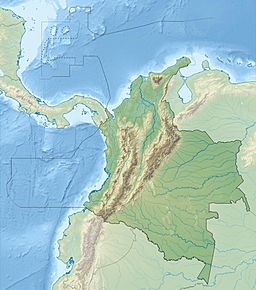
The Gulf of Darién, north of the isthmus of Darién in the Caribbean Sea
|
|
| Location | Caribbean Sea |
| Coordinates | 9°25′42″N 77°3′40″W / 9.42833°N 77.06111°W |
| Type | Gulf |
| Basin countries | Colombia |
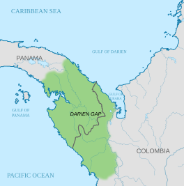
The Gulf of Darién is a part of the Caribbean Sea. It's located in the southernmost area of the Caribbean. You can find it north and east of the border between two countries: Panama and Colombia.
Inside this larger gulf is a smaller area called the Gulf of Urabá. This is like a small "lip" of the sea that stretches south. The port city of Turbo, Colombia is located on its southern shores. The Atrato River also flows into the Gulf of Darién.
The Darien Scheme: Scotland's Big Plan
The Gulf of Darién was once the location of a big plan known as the Darien scheme. This was Scotland's only major attempt to create its own colony in another part of the world. A colony is a territory controlled by a distant country.
The first group of five ships set sail from Leith, Scotland, on July 14, 1698. About 1,200 people were on board. Their goal was to reach the Bay of Darien. They were told to find an island called "Golden Island" and then set up a settlement on the nearby mainland.
After stopping in Madeira and the West Indies, the ships arrived off the coast of Darien on November 2. The settlers named their new home "New Caledonia". This plan, however, did not go well and eventually failed.
See Also
 In Spanish: Golfo de Darién para niños
- Darién Gap
- Guna people
 | James Van Der Zee |
 | Alma Thomas |
 | Ellis Wilson |
 | Margaret Taylor-Burroughs |


