Colombia–Panama border facts for kids
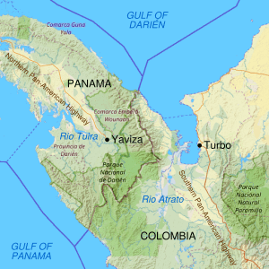
The Colombia–Panama border is a 339-kilometer (211-mile) line that separates Colombia and Panama. This border also goes through the Darién Gap. The Darién Gap is a wild area of forests and mountains. It is a natural break between the South American and North American continents. This special area is found in the northwest of Colombia's Chocó Department and the southeast of Panama's Darién Province.
There is also a missing part in the Pan-American Highway here. This famous road starts in Turbo, Colombia, and stops in Yaviza, Panama. This missing section is about 106 kilometers (66 miles) long. Building a road through this area is very expensive. It would also harm the environment a lot. Because of this, leaders have not agreed to build the road.
Contents
What Does the Border Look Like?
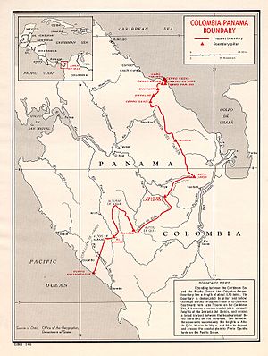
The border begins in the north at a place called Cabo Tiburón, on the coast of the Caribbean Sea. From there, it goes southwest and then southeast. It follows different peaks of the Serranía del Darién mountain range, reaching as far as Alto Limón. Then, it turns southwest again. There's a small part where Colombia sticks out near Cerro Pirre. Finally, the border ends in the south on the Pacific coast at Punto Equidistante.
On the Colombian side, the land is mostly flat and marshy. This is because of the river delta of the Atrato River. This creates a swampy area that is at least 80 kilometers (50 miles) wide. The Serranía del Baudó mountain range runs along Colombia's Pacific coast and into Panama. The Panamanian side is very different. It is a mountainous rainforest. The land goes from about 60 meters (200 feet) high in the valleys to 1,845 meters (6,053 feet) at the tallest peak, Cerro Tacarcuna. This peak is in the Serranía del Darién.
A Look at History
Early History of the Area
We don't know as much about the ancient history of this area as we do about places to its north and south. However, many smart people studied old sites and items here over a hundred years ago. They found many places with large platform mounds, open plazas, paved roads, stone sculptures, and beautiful items made from jade, gold, and ceramic.
The Darién Gap is home to the Embera-Wounaan and Kuna people today. Before the 1500s, the Cueva people also lived here. People often travel by special canoes called piraguas. On the Panamanian side, La Palma is the main town and a cultural center. People here grow important crops like corn, cassava, plantains, and bananas.
The Cunas lived in what is now northern Colombia and Panama's Darién Province when the Spanish arrived. They later moved west because of fights with the Spanish and other groups. Centuries before the Spanish came, the Cunas moved into South America from Central America. When the Spanish arrived, they lived near the borders of what are now Antioquia and Caldas. The Cunas themselves say they moved because of conflicts with other groups. They moved to nearby islands to avoid mosquitoes on the mainland.
European Explorers and Settlements
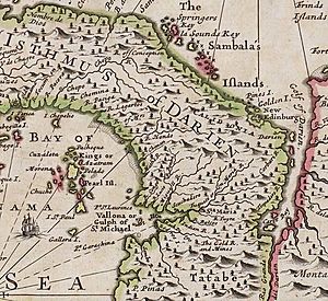
Explorers like Alonso de Ojeda and Vasco Núñez de Balboa explored the coast of Colombia in 1500 and 1501. They spent time in the Gulf of Urabá and met the Cunas. The first border in this region was set in 1508 by a royal order. It separated two colonial areas, Castilla de Oro and Nueva Andalucía. The River Atrato was used as the boundary.
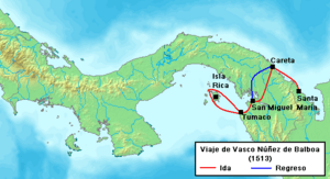
Vasco Núñez de Balboa learned about a "South Sea" from local people. On September 25, 1513, he saw the Pacific Ocean. In 1519, the town of Panamá was started near a small local village on the Pacific coast. After Europeans found Peru, Panamá became an important trading port and a center for government. In 1671, the Welsh pirate Henry Morgan crossed Panama and destroyed the city. The town was moved a few kilometers west to a small peninsula. The old city's ruins, Panamá Viejo, are still there and are a UNESCO World Heritage Site.
The area of modern Colombia, which included Panama at the time, became the Presidency of New Granada in 1564. It was later made into a Viceroyalty in 1718. New Granada included the lands of modern Panama, Colombia, Venezuela, and Ecuador. Silver and gold from Peru were carried across the Darién land bridge. They went to Porto Bello, where Spanish ships took them to Spain.
Scotland tried to start a settlement in 1698. This was called the Darien scheme. It was Scotland's main attempt to create a colony. The first group of ships left Scotland on July 14, 1698, with about 1,200 people. They were told to go to the Bay of Darien and settle on the mainland. They named their new home "New Caledonia."
The goal was for the colony to have a land route connecting the Pacific and Atlantic oceans. But the plan had many problems. There was poor planning, not enough supplies, and bad leadership. Many people got sick. The Spanish army also attacked them. The colony was finally given up in March 1700 after a Spanish attack. This failure caused big money problems in Scotland. Some people believe it helped lead to Scotland joining with England in 1707. The land where the Darien colony was built is mostly empty today.
After Colonial Times
In 1810, Colombia declared its freedom from Spain. It then joined with Venezuela (and later Panama and Ecuador) to form a large country called Gran Colombia in 1819. But this union broke apart in 1829–30. Colombia, including Panama, became the Republic of New Granada. In 1858, this was renamed the Granadine Confederation. In 1855, the state of Panama was created within it, and its border with the rest of the Confederation was set that same year. The country was renamed the United States of Colombia in 1863.
Panama wanted to be independent. In 1903, it declared its freedom with help from the United States. The U.S. wanted to build a canal across Panama.
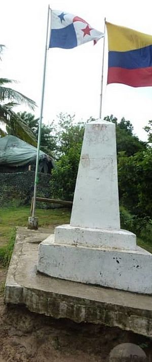
On April 6, 1914, Colombia and the United States signed a treaty. This treaty recognized the border between Colombia and Panama that was set in 1855. Colombia and Panama then signed another border treaty, the Victoria-Velez Treaty, in Bogotá on August 20, 1924. This treaty was officially recorded on August 17, 1925. The border was again based on the same Colombian law from June 9, 1855. The border was then marked on the ground with pillars. The final line was confirmed on June 17, 1938.
Border Challenges
Sometimes, people try to cross the border without permission. In May 2016, Panama closed some border crossings to stop people from Cuba and Africa from entering the country without documents. This caused some people to be stuck in Turbo, Colombia.
See also
 In Spanish: Frontera entre Colombia y Panamá para niños
- Darién Gap
- Darien scheme
- Gulf of Darién
- Lionel Wafer
 | Sharif Bey |
 | Hale Woodruff |
 | Richmond Barthé |
 | Purvis Young |


