Darién Province facts for kids
Quick facts for kids
Darién Province
Provincia de Darién
|
||
|---|---|---|

La Palma
|
||
|
||

Location of Darién Province in Panama
|
||
| Country | Panama | |
| Founded | 1822 | |
| Capital city | La Palma | |
| Area | ||
| • Total | 11,892.5 km2 (4,591.7 sq mi) | |
| Highest elevation | 2,280 m (7,480 ft) | |
| Lowest elevation | 0 m (0 ft) | |
| Population
(2010 census)
|
||
| • Total | 48,378 | |
| • Density | 4.06794/km2 (10.53592/sq mi) | |
| Census | ||
| Time zone | UTC-5 (Eastern Time) | |
| ISO 3166 code | PA-5 | |
| HDI (2017) | 0.761 high |
|
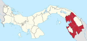
Darién is a large province in Panama. Its capital city is La Palma. Darién is located at the eastern end of Panama, covering about 11,896 square kilometers. This makes it the largest province in Panama by land area.
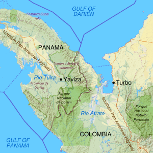
Darién shares borders with the Panamá Province and the Kuna Yala region to the north. To the south, it meets the Pacific Ocean and Colombia. To the east, it borders Colombia, and to the west, it borders the Pacific Ocean and the province of Panama.
A famous part of Darién is the Darién Gap. This is a huge area of undeveloped swamp and forest near the border with Colombia. There are no roads here, making it the only missing part of the Pan-American Highway. This highway stretches from North America to South America.
Contents
What's in a Name? The Origin of Darién
The name "Darién" comes from the language of the Cueva, an Indigenous group. These people lived in the area long ago. The Tanela River, which flows into the Atrato River, was called Darién by the Spanish. Over time, the entire region and its communities took on this name.
Santa María la Antigua del Darién, one of the first European cities in the Americas, was also named after this river. The boundaries of the region were later defined by the Gulf of Urabá.
A Look Back: Darién's History
Darién Province has been home to Indigenous people for thousands of years. Scientists have found signs that people were farming here at least 4,000 years ago. When European explorers arrived, the lives of these early communities changed greatly.
Early European Exploration
In 1508, the Spanish Crown decided to explore and settle the mainland. This large area stretched from Central America to Venezuela. It was divided into two main parts: Nueva Andalucía and Castilla del Oro.
Alonso de Ojeda was the governor of Nueva Andalucía. Diego de Nicuesa was the mayor of Castilla del Oro and later the first governor of the Isthmus of Panama. Nicuesa founded the town of Nombre de Dios in 1510.
Another explorer, Martín Fernández de Enciso, founded Santa Maria la Antigua del Darién in September 1510. He did this with advice from Vasco Núñez de Balboa. Balboa had explored these lands earlier.
Balboa's Discovery of the Pacific Ocean
On September 1, 1513, Balboa set out to find a great sea. He traveled with 190 Spanish explorers and 1,000 Indigenous people. On September 25, 1513, he saw the ocean. Four days later, on September 29, he claimed it for Spain in the Gulf of San Miguel. This was a very important moment in history.
The Scottish Darién Scheme
In the late 1600s, there was a Scottish project to create a colony in Darién. William Paterson, a Scottish banker, led this effort. Scotland wanted to set up a trading post here. This was part of a bigger competition between Spain and other European countries.
On July 14, 1698, Paterson left Scotland with about 1,200 people on five ships. They landed in Darién on October 30, 1698. They made a friendly agreement with a local Indigenous leader. Then, they founded a colony called New Caledonia in a place called Acla.
The Scottish settlers faced attacks from Spanish forces. But the biggest challenge was the climate and diseases. Many people got sick, and the expedition suffered greatly. By June 1699, the Scots had to leave New Caledonia and went to Jamaica.
A second group of 1,300 Scots arrived in November 1699. They faced even stronger resistance from the Spanish. They were surrounded and had no help from outside. On March 28, 1700, they had to surrender to the Spanish. The Scottish colonization project was not successful.
How Darién is Governed
Panama's government is a republic with three main branches. Darién Province follows this system. It has its own local government that works within the country's laws.
Dividing Up Darién: Districts and Communities
Darién Province is split into three main areas called districts. These districts are then divided into smaller communities called corregimientos.
| District |
|
Cabecera (Seat) |
|---|---|---|
| Chepigana1 | La Palma, Camoganti, Chepigana, Garachiné, Jaqué, Puerto Piña, Sambú, Setegantí, Taimatí, Tucutí | La Palma |
| Pinogana | El Real de Santa María, Boca de Cupe, Paya, Pinogana, Púcuro, Yape, Yaviza, Metetí | El Real de Santa María |
| Santa Fe | Agua Fría, Cucunatí, Río Congo, Río Congo Arriba, Río Iglesias, Santa Fe, Zapallal | Santa Fe |
There are also special Indigenous territories called comarca indígena. The Kuna de Wargandí territory is located within the Pinogana District. The Emberá-Wounaan territory was created from parts of Darién Province in 1983. It has two districts: Cémaco and Sambú.
Exploring Darién's Geography
Darién Province is the largest province in Panama, covering about 11,896 square kilometers. This is similar in size to the island of Jamaica. In the middle of the province, there's a flat area with gentle hills. The Chucunaque and Tuira flow through this area.
The flat lands are surrounded by tall mountains. Some of the highest mountains include Tacarcuna (2,280 meters), Piña (1,581 meters), and Pirre (1,569 meters).
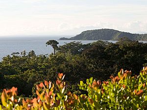
Most of Darién is covered by forests. These forests are either tropical moist or cloud forest, depending on how high they are and how much rain they get. About 25% of the land is protected as forest reserves.
Darién's Climate
Darién Province gets a lot of rain. Near the coast, like in Garachiné, it rains about 1,700 to 2,000 millimeters per year. There is a dry season from January to April, which is typical of a tropical savanna climate.
However, in the mountains and valleys inside the province, it can rain over 8,000 millimeters per year! This means there's almost no dry season, making it one of the rainiest places on Earth. This is known as a tropical rainforest climate. Temperatures usually range from 17 to 35 degrees Celsius, depending on the altitude.
Waterways of Darién
Darién Province has many rivers that flow into large waterways. The Chucunaque (231 km long) and the Tuira River (230 km long) are two of the longest rivers in Panama. The rivers have their lowest water levels in March and April and their highest in November.
Most of the water from these rivers is used to provide drinking water to 15 towns. There might be potential for hydropower (making electricity from water) in rivers like the Pirre, Antad, Tuira, Chico, and Yape.
Who Lives in Darién? Demographics
Darién has a small population that is spread out in many small towns. These towns are often connected by rivers. The people living in Darién come from different backgrounds.
In 1970, about 22,685 people lived here. This included mulattoes, black people, Indigenous groups, and settlers from other parts of Panama. Most people lived in small towns with fewer than 500 residents.
By 2010, the population had grown to about 46,951 people. This included 25,764 men and 21,187 women.
Darién's Rich Culture
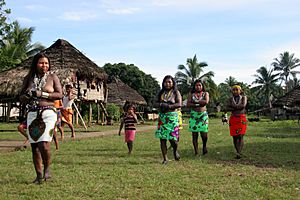
The people of Darién are mainly Indigenous, Afro-Descendants, and settlers who moved from other Panamanian provinces. They came looking for land and new chances.
Music and Food
The traditional music of Darién is the bullerengue. This is a drum dance that has roots in African culture. Radio stations in the province often play bullerengue. Closer to the Colombian border, you might hear vallenato music, which is popular in Colombia.
Some common foods in Darién include guacho de mariscos (fish with coconut rice) and serendengue. A traditional drink is choca'o, which is stewed plantain.
Daily Life and Economy
Women in Darién often wear beautiful hand-sewn dresses. Men usually dress in business attire. The main crops grown here are corn, rice, plantains, bananas, cassava, yams, and beans.
In the Gulf of San Miguel, there are many shrimp, fish, and lobsters. A fishing fleet from Panama City operates here. In the inland rivers, people mostly fish for their own food. The lumber industry is also important, providing valuable woods like cedar, balsa, mahogany, and cocobolo.
Videos
- Tierra Adentro (Inland) is a film documentary by Mauro Colombo. It shows the dangerous border between Panama and Colombia. It features guerrillas, immigrants, Indigenous people, farmers, local police, and wild animals. This film was shown at the Rotterdam International Film Festival in 2019.
Sources
- Alì, Maurizio. (2012). "Megaproyectos y efectos perversos de la modernidad: el bizarro caso de Uraba". Revista Perfiles Libertadores, 8: 72–80. Bogotá, Colombia. Fundación Universitaria Los Libertadores. ISSN 2248-5724
- Panama in Figures: 2000–2004 Statistics and Census of the Comptroller General of the Republic of Panama.
See also
 In Spanish: Provincia de Darién para niños
 | Lonnie Johnson |
 | Granville Woods |
 | Lewis Howard Latimer |
 | James West |


