Tuira River facts for kids
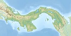
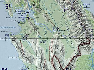
The Tuira River is a very important river located in the Darién Province in eastern Panama. It is the largest river in Panama! This mighty river flows into the Bay of San Miguel near the capital city of the province, La Palma.
Quick facts for kids Tuira River |
|
|---|---|
|
Location of mouth
|
|
| Native name | Rio Tuira (Spanish) |
| Country | Panama |
| Province | Darién Province |
| Physical characteristics | |
| River mouth | 0 m (0 ft) 8°19′10″N 78°18′31″W / 8.3194°N 78.3086°W |
| Length | 230 km (140 mi) |
| Basin features | |
| Basin size | 10,664.42 km2 (4,117.56 sq mi) |
Contents
Panama's Longest River System
The Tuira River is the biggest river in Panama. One of its main branches, the Chucunaque River, is actually the longest river in the entire country! Together, they form a huge river system.
Where the River Begins and Flows
The Tuira River starts high up in the mountains of the Darién region. It first flows south and southeast. Then, it changes direction, heading north and west.
As it travels downstream, the river passes many small villages. Some of these include Matuganti, Sobiaquirú, El Balsal, Boca de Cupe, Capetí, Yape, Aruza, Unión Chocó, Vista Alegre, and Pinogana.
Meeting Other Rivers
The Tuira River eventually meets the Chucunaque River at a place called El Real de Santa María. After this meeting, the combined rivers flow northwest. They continue their journey towards La Palma, where they finally reach the ocean.
The Chucunaque River is very important. It allows people to travel by boat all the way to Yaviza. Yaviza is a special place because it's where the northern part of the famous Pan-American Highway ends.
Other River Connections
Two other rivers also join the Tuira River. The Paya River flows into the Tuira after it passes Sobiaquirú. Through the Paya River, you can reach the village of Paya.
Further downstream, the Púcuro River also joins the Tuira. This connection allows access to the village of Púcuro.
See also
 In Spanish: Río Tuira para niños
 | Claudette Colvin |
 | Myrlie Evers-Williams |
 | Alberta Odell Jones |


