Gurley, New South Wales facts for kids
Quick facts for kids GurleyNew South Wales |
|||||||||||||||
|---|---|---|---|---|---|---|---|---|---|---|---|---|---|---|---|

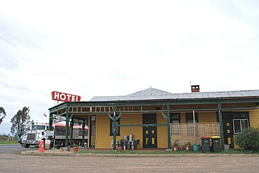
Royal Hotel at Gurley
|
|||||||||||||||
| Population | 236 (2016 census) | ||||||||||||||
| Postcode(s) | 2398 | ||||||||||||||
| Elevation | 220 m (722 ft) | ||||||||||||||
| Location | |||||||||||||||
| LGA(s) | Moree Plains Shire | ||||||||||||||
| State electorate(s) | Northern Tablelands | ||||||||||||||
| Federal Division(s) | Parkes | ||||||||||||||
|
|||||||||||||||
Gurley is a small town in the North West Slopes region of New South Wales, Australia. It's located between the towns of Narrabri and Moree. The main road, called the Newell Highway, and the North-West railway line both pass right through Gurley.
History of Gurley
The Post Office in Gurley first opened on March 16, 1898. Back then, it was called Gurley Siding. Later, in 1917, its name was officially changed to just Gurley. A railway station also opened here in 1897, but it is now closed.
Economy and Agriculture
Gurley's economy mostly depends on farming. In 2022, the Australian Taxation Office reported that Gurley had the lowest average taxable income in Australia. Taxable income is the amount of money people earn that can be taxed. This low number was likely because of tough farming conditions that year.
Gurley Railway Station
The railway station in Gurley was once an important stop on the train line.
| Preceding station | Former Services | Following station | ||
|---|---|---|---|---|
| Moree
towards Mungindi
|
Mungindi Line | Bellata
towards Werris Creek
|
||
 | Aurelia Browder |
 | Nannie Helen Burroughs |
 | Michelle Alexander |


