Guáimaro facts for kids
Quick facts for kids
Guáimaro
|
||
|---|---|---|

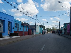
Main street
|
||
|
||

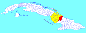
Guáimaro municipality (red) within
Camagüey Province (yellow) and Cuba |
||
| Country | Cuba | |
| Province | Camagüey | |
| Established | 1924 | |
| Area | ||
| • Total | 1,847 km2 (713 sq mi) | |
| Elevation | 80 m (260 ft) | |
| Population
(2022)
|
||
| • Total | 36,114 | |
| • Density | 19.553/km2 (50.641/sq mi) | |
| Time zone | UTC-5 (EST) | |
| Area code(s) | +53-322 | |
| Climate | Aw | |
Guáimaro is a town and a municipality in the southern part of Camagüey Province in Cuba. It is located between the cities of Camagüey and Las Tunas. Guáimaro is well-known for its important role in Cuban history.
Contents
History of Guáimaro
Guáimaro holds a special place in Cuba's past. In 1869, at the very beginning of the Ten Years' War, a group of Cuban freedom fighters met here. These fighters, known as the Mambises, wanted Cuba to be free from Spanish rule.
The Guáimaro Constitution
During their meeting, the Mambises created a very important document. It was called the Guáimaro Constitution. This constitution was a plan for a new, independent nation. It showed their strong desire for freedom. The municipality of Guáimaro was officially created much later, in 1943. Before that, it was part of Camagüey.
Geography of Guáimaro
The municipality of Guáimaro is divided into several smaller areas. These areas are called barrios. Some of the barrios include Camaniguán, Elia, Galbis, Guáimaro, Palo Seco, Pilar, and Tetuán.
Population and Demographics
In 2022, the municipality of Guáimaro had a total population of 36,114 people. The area of the municipality is about 1,847 square kilometers (713 square miles). This means that on average, there are about 20 people living in each square kilometer.
See also
 In Spanish: Guáimaro para niños
 | Jewel Prestage |
 | Ella Baker |
 | Fannie Lou Hamer |


