
Güicán facts for kids
Quick facts for kids
Güicán
|
|||
|---|---|---|---|
|
Municipality and town
|
|||
| Guicán de la Sierra | |||
 |
|||
|
|||

Location of the municipality and town of Güicán in the Boyacá Department of Colombia.
|
|||

Güicán
Location in Colombia
|
|||
| Country | |||
| Department | |||
| Province | Gutiérrez | ||
| Area | |||
| • Total | 934.04 km2 (360.63 sq mi) | ||
| Elevation | 3,492 m (11,457 ft) | ||
| Population
(2020)
|
|||
| • Total | 6,426 | ||
| • Density | 6.8798/km2 (17.8186/sq mi) | ||
| Time zone | UTC-5 (COT) | ||
| Postal code |
151440
|
||


Güicán de la Sierra is a cool town and area (called a municipality) in Colombia. It's located in the Boyacá Department. You might also hear it called Nuestra Señora de la Candelaria de Güicán.
This town is very close to a beautiful national park called El Cocuy National Park. In 2020, about 6,426 people lived in Güicán.
Contents
What's in a Name? The Meaning of Güicán
The name of this place comes from an old tribe called the Güicán people. These indigenous people used to live in this very region. They are related to the U'wa people. In their language, the name Güicán means "in the fence of the wife."
A Look Back: The History of Güicán
Early Days and Spanish Arrival
Long ago, the Güicán area was home to the Güicán tribe. Then, a Spanish explorer named Hernán Pérez de Quesada arrived. He came with his soldiers, looking for gold. The native people moved behind the Sierra Nevada mountains to get away from the Spanish.
Founding of the Town
The town of Güicán was officially started on February 26, 1756. It was founded by a Jesuit friar named Miguel Blasco.
Exploring the Geography of Güicán
Güicán is located high up in the mountains. Its average height is about 3,492 meters (that's over 11,400 feet!) above sea level.
Neighboring Areas
Güicán shares its borders with several other towns and areas:
- To the north, it borders Chiscas and Cubará.
- To the east, you'll find Fortul and Saravena.
- To the south, it borders Tame and El Cocuy.
- To the west, it's next to Panqueba and El Espino.
Understanding Güicán's Climate
Güicán has a special kind of weather called a Tundra Climate (ET). This means it's generally cold, and you won't find many trees growing there.
Rainfall in Güicán
The town gets the most rain in April. On average, it receives about 244 millimeters (or about 9.6 inches) of rain that month. The driest month is January, with only about 83 millimeters (around 3.3 inches) of rain.
| Climate data for Güicán, elevation 2,963 m (9,721 ft), (1981–2010) | |||||||||||||
|---|---|---|---|---|---|---|---|---|---|---|---|---|---|
| Month | Jan | Feb | Mar | Apr | May | Jun | Jul | Aug | Sep | Oct | Nov | Dec | Year |
| Mean daily maximum °C (°F) | 20.1 (68.2) |
20.6 (69.1) |
20.2 (68.4) |
18.8 (65.8) |
18.4 (65.1) |
18.3 (64.9) |
18.1 (64.6) |
18.5 (65.3) |
18.7 (65.7) |
18.5 (65.3) |
18.4 (65.1) |
19.2 (66.6) |
18.9 (66.0) |
| Daily mean °C (°F) | 13.5 (56.3) |
13.6 (56.5) |
13.7 (56.7) |
13.4 (56.1) |
13.2 (55.8) |
13.0 (55.4) |
12.9 (55.2) |
12.9 (55.2) |
12.9 (55.2) |
12.9 (55.2) |
12.9 (55.2) |
13.2 (55.8) |
13.2 (55.8) |
| Mean daily minimum °C (°F) | 7.3 (45.1) |
7.6 (45.7) |
8.1 (46.6) |
8.8 (47.8) |
9.1 (48.4) |
8.8 (47.8) |
8.3 (46.9) |
8.1 (46.6) |
8.2 (46.8) |
8.3 (46.9) |
8.2 (46.8) |
7.6 (45.7) |
8.2 (46.8) |
| Average precipitation mm (inches) | 28.0 (1.10) |
41.9 (1.65) |
83.9 (3.30) |
119.2 (4.69) |
138.8 (5.46) |
91.5 (3.60) |
82.1 (3.23) |
91.9 (3.62) |
103.8 (4.09) |
135.5 (5.33) |
103.2 (4.06) |
51.2 (2.02) |
1,032.7 (40.66) |
| Average precipitation days (≥ 1.0 mm) | 8 | 10 | 15 | 19 | 23 | 22 | 22 | 21 | 20 | 22 | 19 | 13 | 206 |
| Average relative humidity (%) | 81 | 80 | 82 | 85 | 87 | 87 | 86 | 85 | 85 | 85 | 86 | 83 | 84 |
| Source: Instituto de Hidrologia Meteorologia y Estudios Ambientales | |||||||||||||
Images for kids
-
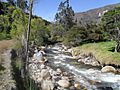
Río Cóncavo as it passes through Güicán.
-
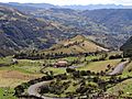
View of the rural sector of Güicán.
-
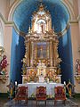
Main altar of the Sanctuary of the Morenita Virgin
-
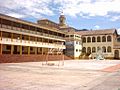
Old physical plant of the ENS Nuestra Señora del Rosario de Güicán.


See also
 In Spanish: Güicán para niños
