
Boyacá facts for kids
Quick facts for kids
Boyaca Department
Departamento de Boyacá
|
|||
|---|---|---|---|
|
Department of Colombia
|
|||

Simón Bolívar square, Tunja
|
|||
|
|||

Location of Boyacá, in red, in Colombia
|
|||
| Country | |||
| Capital | Tunja | ||
| Municipalities | 123 | ||
| Area | |||
| • Total | 23,189 km2 (8,953 sq mi) | ||
| Population
(2005)
|
|||
| • Total | 1,255,311 | ||
| • Density | 54.1339/km2 (140.2062/sq mi) | ||
| Demonym(s) | Boyacense | ||
| Time zone | UTC-5 (UTC) | ||
| Postal code |
15
|
||
| ISO 3166 code | CO-BOY | ||
| Website | Gobernación de Boyacá | ||


Boyacá is one of the 32 departments in Colombia. It is located in the central northeastern part of the country. Most of Boyacá is within the mountains of the Eastern Cordillera. This mountain range stretches all the way to the border with Venezuela. The western part of the department reaches the Magdalena River. Its capital is Tunja.
Boyacá is often called "The Land of Freedom." This is because many important battles for Colombia's independence from Spain happened here.
Contents
History of Boyacá

Long ago, before Europeans arrived, the land of Boyacá was home to the Muisca indigenous peoples. They were skilled farmers and also mined for gold and emeralds.
The first European to explore this area was Gonzalo Jiménez de Quesada from Spain. In 1539, another Spanish colonist, Gonzalo Suárez Rendón, founded the city of Tunja. Tunja became a major center for the Spanish during the time of the "Viceroyalty of New Granada."
During the 1800s, Boyacá was a key battleground during the war for independence. Two very important battles took place here:
- The "Battle of the Pantano de Vargas" (Vargas Swamp Battle) on July 25, 1819.
- The "Battle of Boyacá" on August 7, 1819. These battles helped Colombia gain its freedom.
Geography and Climate
The Boyacá department is located in the Andean region. It sits on the mountains of the Eastern Cordillera. This is the eastern part of the Andes mountains in Colombia.
Boyacá shares borders with eight other departments:
- To the north: Santander and Norte de Santander.
- To the east: Arauca and Casanare.
- To the south: Cundinamarca and Meta.
- To the west: Caldas and Antioquia.
It also borders Venezuela.
Boyacá covers an area of about 23,189 square kilometers (8,953 square miles). Most of this area is a plateau (a flat area high above sea level). The highest point is Ritacuba Blanco. This mountain is 5,410 meters (17,750 feet) high.
Many rivers begin in Boyacá. The most important ones are the Chicamocha and Arauca rivers. These rivers flow into bigger rivers like the Magdalena and Meta rivers.
Boyacá also has many lakes. The largest lake in Boyacá, and in all of Colombia, is Lake Tota. It covers an area of 55 square kilometers (21 square miles).
What is the climate like in Boyacá?
The area around Tunja is about 2,828 meters (9,278 feet) above sea level. It has a climate with mild temperatures and plenty of rain all year. This type of climate is called a "Marine West Coast Climate" or "Cfb" in the Köppen climate system.
On average, Tunja gets about 645.2 millimeters (25.4 inches) of rain each year. October is usually the wettest month, with about 86.4 millimeters (3.4 inches) of rain. January is the driest month, with only about 15.2 millimeters (0.6 inches) of rain. Tunja has rain for about 179 days a year. May has the most rainy days (19 days), and January has the fewest (6 days).
The average temperature in Tunja for the whole year is 13.2°C (55.8°F). March is usually the warmest month, with an average of 14.1°C (57.4°F). July is the coolest month, with an average of 12.2°C (54.0°F).
| Climate data for Tunja, Colombia | |||||||||||||
|---|---|---|---|---|---|---|---|---|---|---|---|---|---|
| Month | Jan | Feb | Mar | Apr | May | Jun | Jul | Aug | Sep | Oct | Nov | Dec | Year |
| Mean daily maximum °C (°F) | 19.1 (66.4) |
19.3 (66.7) |
19.2 (66.6) |
18.4 (65.1) |
17.3 (63.1) |
16.4 (61.5) |
16.0 (60.8) |
16.5 (61.7) |
17.3 (63.1) |
17.9 (64.2) |
18.2 (64.8) |
18.4 (65.1) |
17.8 (64.1) |
| Daily mean °C (°F) | 13.2 (55.8) |
13.7 (56.7) |
14.1 (57.4) |
14.1 (57.4) |
13.5 (56.3) |
12.8 (55.0) |
12.2 (54.0) |
12.3 (54.1) |
12.8 (55.0) |
13.3 (55.9) |
13.6 (56.5) |
13.1 (55.6) |
13.2 (55.8) |
| Mean daily minimum °C (°F) | 7.2 (45.0) |
8.1 (46.6) |
9.0 (48.2) |
9.7 (49.5) |
9.7 (49.5) |
9.1 (48.4) |
8.4 (47.1) |
8.2 (46.8) |
8.2 (46.8) |
8.7 (47.7) |
9.0 (48.2) |
7.8 (46.0) |
8.6 (47.5) |
| Average rainfall mm (inches) | 16 (0.6) |
29 (1.1) |
55 (2.2) |
77 (3.0) |
84 (3.3) |
58 (2.3) |
46 (1.8) |
42 (1.7) |
54 (2.1) |
85 (3.3) |
69 (2.7) |
31 (1.2) |
646 (25.3) |
| Source: Weatherbase.com [1] | |||||||||||||
Provinces and Towns
Boyacá Department is divided into 13 provinces and two special districts. These areas contain a total of 123 municipalities (towns or cities). The main town (capital) for each province is shown in bold.
.svg)
|
Centro
Gutiérrez
La Libertad
Lengupá
|
Occidente
Márquez
Neira
|
Norte
Oriente
Ricaurte
|
Sugamuxi
Tundama
Valderrama
Distrito Fronterizo
Special Handling Zone
|
People of Boyacá
The people who live in the Boyacá department are called Boyacense in Spanish.
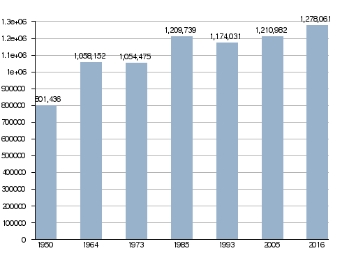
In 2005, Boyacá had a population of 1,255,311 people. This means there were about 54 people living in each square kilometer (140 people per square mile).
Population history in Boyacá
Here are the 10 towns with the most people in Boyacá:
| City | Population (2005) |
Province |
|---|---|---|
| Tunja | 154,096 | Centro |
| Sogamoso | 117,094 | Sugamuxi |
| Duitama | 107,406 | Tundama |
| Chiquinquirá | 55,786 | Occidente |
| Puerto Boyacá | 50,301 | Special Handling Zone |
| Paipa | 27,766 | Tundama |
| Moniquirá | 21,852 | Ricaurte |
| Samacá | 17,614 | Centro |
| Garagoa | 16,520 | Neira |
| Villa de Leyva | 12,032 | Ricaurte |
Economy of Boyacá
Farming is a very important activity in Boyacá. Some of the main crops grown here are sugarcane, coffee, and cacao (used to make chocolate). Raising Cattle is also a big part of the economy.
Mining is another key activity. Boyacá is well-known for its emeralds and coal.
Fun Places to Visit
Boyacá has many interesting places to visit:
- Monument to the Lancers (Spanish: Monumento a los Lanceros): This is a huge memorial that remembers the Vargas Swamp Battle. It is the largest monument in Colombia.
- Villa de Leyva: This is a beautiful colonial town that attracts many tourists. It is about 37 kilometers (23 miles) west of Tunja.
- Battleground of the Battle of Boyacá: This historic site is located south of Tunja.
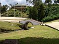
- Puente de Boyacá (The Bridge of Boyacá): This small bridge is about 14 kilometers (9 miles) west of Tunja. It marks the spot of the famous Battle of Boyacá on August 7, 1819.
- Lake Tota: This is the largest fresh water lake in Colombia.
- Basílica of Our Lady of the Rosary in Chiquinquirá: This important church honors Our Lady of the Rosary, who is the patron saint of Colombia.
Images for kids
-
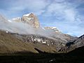
The Ritacuba Blanco mountain
-
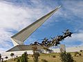
Monument to the Lancers
-
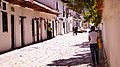
A street in Villa de Leyva
-
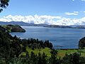
Lake Tota
-
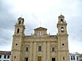
Our Lady of the Rosary Basilica, Chiquinquirá
-
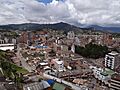
Duitama downtown
-
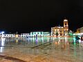
Tunja historical centre by night
-
Bridge of Boyacá


See also
 In Spanish: Boyacá (desambiguación) para niños
