
Hérisson facts for kids
Quick facts for kids
Hérisson
|
||
|---|---|---|

A general view of Hérisson
|
||
|
||

Hérisson
Location in France

Hérisson
Location in Auvergne-Rhône-Alpes
|
||
| Country | France | |
| Region | Auvergne-Rhône-Alpes | |
| Department | Allier | |
| Arrondissement | Montluçon | |
| Canton | Hérisson | |
| Intercommunality | Pays de Tronçais | |
| Area
1
|
32.57 km2 (12.58 sq mi) | |
| Population
(2008)
|
676 | |
| • Density | 20.755/km2 (53.76/sq mi) | |
| Time zone | UTC+01:00 (CET) | |
| • Summer (DST) | UTC+02:00 (CEST) | |
| INSEE/Postal code |
03127 /03190
|
|
| Elevation | 177–327 m (581–1,073 ft) (avg. 199 m or 653 ft) |
|
| 1 French Land Register data, which excludes lakes, ponds, glaciers > 1 km2 (0.386 sq mi or 247 acres) and river estuaries. | ||
.svg)
Hérisson is a small town, also called a commune, in the middle of France. It is located in the Allier department.
Contents
Understanding Hérisson's Population
The number of people living in a place is called its population. This number can change over time. Knowing the population helps us understand how a town grows or shrinks.
How Many People Live in Hérisson?
The population of Hérisson has changed over the years. Here's a look at how many people lived there at different times:
| Historical population | ||
|---|---|---|
| Year | Pop. | ±% |
| 1962 | 916 | — |
| 1968 | 1,043 | +13.9% |
| 1975 | 979 | −6.1% |
| 1982 | 872 | −10.9% |
| 1990 | 801 | −8.1% |
| 1999 | 709 | −11.5% |
| 2008 | 676 | −4.7% |
| 2012 | 636 | −5.9% |
| Source: INSEE | ||
The numbers above come from INSEE. This is the National Institute of Statistics and Economic Studies in France. They collect important information about the country, including how many people live in each town.
Exploring Hérisson Through Pictures
Here are some pictures that show different parts of Hérisson. They include churches and old buildings.
-
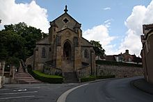
The Church of Notre-Dame
-
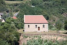
The Chapelle du Calvaire
-
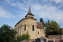
The Église de Châteloy

.JPG)
_Eglise_de_Chateloy_(2).jpg)
-
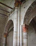
Inside the Église de Châteloy
-
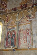
A fresco inside the Église de Châteloy
-
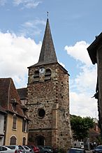
The old church of Église Saint-Sauveur
-
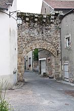
The Porte de Varenne, an old gate
_Eglise_de_Chateloy_(3).jpg)
_Eglise_de_Chateloy_(5).jpg)


See also
 In Spanish: Hérisson para niños
