Arrondissement of Montluçon facts for kids
Quick facts for kids
Arrondissement of Montluçon
|
|
|---|---|

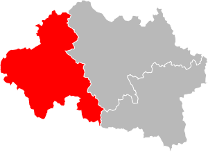
Location of the arrondissement Montluçon in Allier
|
|
| Country | France |
| Region | Auvergne-Rhône-Alpes |
| Department | Allier |
| Communes | 89 |
| Subprefecture | Montluçon |
| INSEE code | 031 |
| Area | |
| • Total | 2,327.9 km2 (898.8 sq mi) |
| Population
(2014)
|
|
| • Total | 114,756 |
| • Density | 49.2959/km2 (127.676/sq mi) |
The arrondissement of Montluçon is a special area in France. It is like a large district within the Allier department. Its main city, or "capital," is Montluçon. This city is also a "subprefecture," which means it's an important administrative center for the department.
Contents
History of Montluçon Arrondissement
The Montluçon area has a long history in France's administrative system. On March 4, 1790, when the Allier department was created, Montluçon was set up as one of its original "districts." Districts were early forms of administrative areas.
Later, on February 17, 1800, the system changed. The "arrondissements" were created, and Montluçon became one of the first arrondissements. This means it has been an important part of the Allier department for a very long time.
Where is Montluçon Arrondissement?
The Arrondissement of Montluçon is located in the western part of the Allier department. It shares borders with several other areas. To the north, it touches the Cher department. To the east, you'll find the Moulins arrondissement.
To the southeast, it borders the Vichy arrondissement. The Puy-de-Dôme department is to the south. Finally, to the west, it meets the Creuse department.
This arrondissement covers a large area of about 2,328 square kilometers (about 899 square miles). It is the second largest area in the Allier department. In 2014, about 114,756 people lived here. This means there were about 49 people living in each square kilometer.
Cities and Towns in Montluçon
The Arrondissement of Montluçon includes 89 different cities and towns, which are called communes in France. Each commune has a special INSEE code, which is like an identification number.
Here are some of the communes you can find in this arrondissement:
- Ainay-le-Château (03003)
- Archignat (03005)
- Arpheuilles-Saint-Priest (03007)
- Audes (03010)
- Beaune-d'Allier (03020)
- Bézenet (03027)
- Bizeneuille (03031)
- Blomard (03032)
- Braize (03037)
- Le Brethon (03041)
- La Celle (03047)
- Cérilly (03048)
- Chambérat (03051)
- Chamblet (03052)
- La Chapelaude (03055)
- Chappes (03058)
- Chavenon (03070)
- Chazemais (03072)
- Colombier (03081)
- Commentry (03082)
- Cosne-d'Allier (03084)
- Courçais (03088)
- Deneuille-les-Mines (03097)
- Désertines (03098)
- Domérat (03101)
- Doyet (03104)
- Durdat-Larequille (03106)
- Estivareilles (03111)
- Haut-Bocage (03158)
- Hérisson (03127)
- Huriel (03128)
- Hyds (03129)
- Isle-et-Bardais (03130)
- Lamaids (03136)
- Lavault-Sainte-Anne (03140)
- Lételon (03143)
- Lignerolles (03145)
- Louroux-Bourbonnais (03150)
- Louroux-de-Beaune (03151)
- Malicorne (03159)
- Marcillat-en-Combraille (03161)
- Mazirat (03167)
- Meaulne-Vitray (03168)
- Mesples (03172)
- Montluçon (03185)
- Montmarault (03186)
- Montvicq (03189)
- Murat (03191)
- Nassigny (03193)
- Néris-les-Bains (03195)
- La Petite-Marche (03206)
- Prémilhat (03211)
- Quinssaines (03212)
- Reugny (03213)
- Ronnet (03216)
- Saint-Angel (03217)
- Saint-Bonnet-Tronçais (03221)
- Saint-Bonnet-de-Four (03219)
- Saint-Caprais (03222)
- Saint-Désiré (03225)
- Saint-Éloy-d'Allier (03228)
- Sainte-Thérence (03261)
- Saint-Fargeol (03231)
- Saint-Genest (03233)
- Saint-Marcel-en-Marcillat (03244)
- Saint-Marcel-en-Murat (03243)
- Saint-Martinien (03246)
- Saint-Palais (03249)
- Saint-Priest-en-Murat (03256)
- Saint-Sauvier (03259)
- Saint-Victor (03262)
- Sauvagny (03269)
- Sazeret (03270)
- Teillet-Argenty (03279)
- Terjat (03280)
- Theneuille (03282)
- Tortezais (03285)
- Treignat (03288)
- Urçay (03293)
- Valigny (03296)
- Vallon-en-Sully (03297)
- Vaux (03301)
- Venas (03303)
- Verneix (03305)
- Vernusse (03308)
- Le Vilhain (03313)
- Villebret (03314)
- Villefranche-d'Allier (03315)
- Viplaix (03317)
Largest Communes by Population
Here are the communes with the most people living in them within the Montluçon arrondissement, based on 2014 data:
| INSEE code |
Commune | Population (2014) |
|---|---|---|
| 03185 | Montluçon | 37,289 |
| 03101 | Domérat | 8,985 |
| 03082 | Commentry | 6,395 |
| 03098 | Désertines | 4,304 |
| 03195 | Néris-les-Bains | 2,701 |
| 03128 | Huriel | 2,700 |
| 03211 | Prémilhat | 2,434 |
| 03262 | Saint-Victor | 2,107 |
| 03084 | Cosne-d'Allier | 2,098 |
| 03297 | Vallon-en-Sully | 1,635 |
See also
 In Spanish: Distrito de Montluçon para niños
 | George Robert Carruthers |
 | Patricia Bath |
 | Jan Ernst Matzeliger |
 | Alexander Miles |

