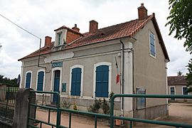
Reugny, Allier facts for kids
Quick facts for kids
Reugny
|
|
|---|---|
 |
|
| Country | France |
| Region | Auvergne-Rhône-Alpes |
| Department | Allier |
| Arrondissement | Montluçon |
| Canton | Hérisson |
| Intercommunality | Val de Cher |
| Area
1
|
7.66 km2 (2.96 sq mi) |
| Population
(2008)
|
263 |
| • Density | 34.33/km2 (88.93/sq mi) |
| Time zone | UTC+01:00 (CET) |
| • Summer (DST) | UTC+02:00 (CEST) |
| INSEE/Postal code |
03213 /03190
|
| Elevation | 178–282 m (584–925 ft) (avg. 204 m or 669 ft) |
| 1 French Land Register data, which excludes lakes, ponds, glaciers > 1 km2 (0.386 sq mi or 247 acres) and river estuaries. | |
Reugny is a small village, also known as a commune, located in the heart of France. It is found in the Allier department. This area is in the central part of the country.
Contents
Discovering Reugny
Reugny is a quiet place with a small population. It is part of the Allier department. This department is known for its green landscapes.
Where is Reugny Located?
Reugny is in the Allier department. This department is in the Auvergne-Rhône-Alpes region of France. It is near the town of Montluçon. The village is situated in the middle of the country.
How Many People Live Here?
In 2008, about 263 people lived in Reugny. This makes it a very small community. Small villages often have a close-knit feel.
The Mayor of Reugny
The mayor of Reugny is Alice Lachassagne. A mayor is the leader of a town or city. They help manage local services. These services include things like roads and schools. Alice Lachassagne served as mayor from 2008 to 2014.
Reugny's Geography
Reugny covers an area of about 7.66 square kilometers. That is roughly 3 square miles. The village sits at an average height of 204 meters above sea level. This is about 669 feet high. The lowest point is 178 meters. The highest point is 282 meters.
See also
 In Spanish: Reugny (Allier) para niños
 | Chris Smalls |
 | Fred Hampton |
 | Ralph Abernathy |


