Haut-Bocage facts for kids
Quick facts for kids
Haut-Bocage
|
|
|---|---|

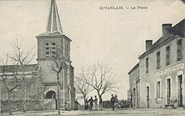
1920s era post card from Givarlais (delegated commune)
|
|
| Country | France |
| Region | Auvergne-Rhône-Alpes |
| Department | Allier |
| Arrondissement | Montluçon |
| Canton | Huriel |
| Intercommunality | CC du Val de Cher |
| Area
1
|
70.64 km2 (27.27 sq mi) |
| Population
(2021)
|
855 |
| • Density | 12.104/km2 (31.348/sq mi) |
| Time zone | UTC+01:00 (CET) |
| • Summer (DST) | UTC+02:00 (CEST) |
| INSEE/Postal code |
03158 /03190
|
| 1 French Land Register data, which excludes lakes, ponds, glaciers > 1 km2 (0.386 sq mi or 247 acres) and river estuaries. | |
Haut-Bocage (pronounced "Oh Boh-kahj") is a special type of local area in central France called a commune. It's located in the Allier department. Think of a commune as a small town or district with its own local government.
This commune was officially created on January 1, 2016. It was formed by combining three smaller, older communes: Maillet, Givarlais, and Louroux-Hodement. This means these three places now work together under one local administration.
Where is Haut-Bocage?
Haut-Bocage is found in the heart of France. It's part of the Auvergne-Rhône-Alpes region. The area is known for its beautiful countryside, often called "bocage," which means a landscape with fields and woodlands. This is where the name "Haut-Bocage" comes from, meaning "High Bocage" or "Upper Bocage."
People Living in Haut-Bocage
The number of people living in Haut-Bocage changes over time. This information helps us understand how the commune has grown or changed. The data below shows the population figures for the commune based on its geography as of January 2023.
| Historical population | ||
|---|---|---|
| Year | Pop. | ±% p.a. |
| 1968 | 1,080 | — |
| 1975 | 947 | −1.86% |
| 1982 | 838 | −1.73% |
| 1990 | 840 | +0.03% |
| 1999 | 842 | +0.03% |
| 2009 | 950 | +1.21% |
| 2014 | 896 | −1.16% |
| 2020 | 860 | −0.68% |
| Source: INSEE | ||
Local Government
Like all communes in France, Haut-Bocage has a local government. The mayor is the head of this government. The current mayor is Jean-Michel Laprugne, and his term is from 2020 to 2026. The commune also works with other nearby communes in a group called the "Communauté de communes du Val de Cher." This group helps manage shared services and projects for the area.
See also
 In Spanish: Haut-Bocage para niños
 | William M. Jackson |
 | Juan E. Gilbert |
 | Neil deGrasse Tyson |


