Haining Place and the Barony of Haining-Ross facts for kids
Quick facts for kids Haining Place |
|
|---|---|
| Hurlford, East Ayrshire, Scotland UK |
|
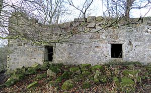
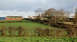
Haining Place in 2015
|
|
| Coordinates | 55°34′57″N 4°27′24″W / 55.582565°N 4.456618°W |
| Type | Tower house |
| Site information | |
| Owner | Private |
| Controlled by | Ross family |
| Open to the public |
No |
| Condition | Ruined |
| Site history | |
| Built | 16/17th century |
| Materials | Stone |
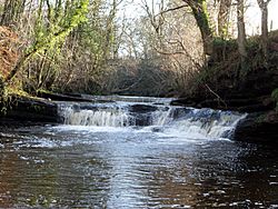
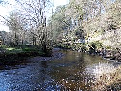
Haining Place is an old ruined building near Hurlford in East Ayrshire, Scotland. It was once a strong tower house, built on a high piece of land next to the Cessnock Water river. This made it a good place for defence.
Over time, Haining Place changed. It might have been a "dower house" (a home for a widow), then a farm, and finally, a place for farm workers to live. Sadly, a fire damaged it, and now it's a ruin. The old farm, Haining Mains, is still nearby.
Contents
History of Haining Place
Haining Place was part of a larger area called the Barony of Haining-Ross. A "barony" was like a large estate or land area owned by a powerful family, often with special rights. Records from 1665 show that this barony was in the area of Riccarton.
The land around Haining Place was very important. It had defences, a chapel, and even a mill called Craigmill on the Cessnock Water. There were also many woodlands and gardens. Some old records from 1498 mention the "Gardens of Haining."
What's in a Name?
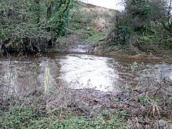
Old maps sometimes called this place "Hatting." This name might come from an old Gaelic word, athan, which means "a ford" or a place where you can cross a river. Haining Place is indeed located near an old river crossing with stepping stones.
The name "Haining" itself comes from a Scots word. It means a "fence, hedge, or wall" that creates an enclosed area. This was often done to protect hay crops from animals like cattle or deer. It's interesting because Haining once had a very long fence around its deer park.
Archaeologists found three iron "caltrops" at Haining. These were sharp metal objects thrown on the ground to injure horses. They were used as a defence against attackers. There's also a place called Tinkers Hill nearby. It might have been the "moot hill" for the barony. A moot hill was where the laird (the lord of the land) held his local courts and made decisions.
The Ross Family of Haining
The Ross family were the main owners of Haining-Ross for a long time. In the 14th century, Andrew de Ross was an important ancestor of the Ross families in this area. Some Ross family lands were taken away because they supported John Balliol, who was a king of Scotland for a short time. But some lands were given back later.
In 1475, John Ross owned Haining. Later, his family members married into other important families. For example, in 1521, Janet Ross married Robert Lindsay in the chapel at Haining.
George Ross of Haining was involved in a conflict called the 'Langside rebellion' in 1571. But he was forgiven as long as he behaved well in the future. In 1597, Matthew Ross of Haining officially took possession of the lands.
By 1685, the king, James VII, took control of Haining-Ross from the Campbell family. This meant the land became part of the Crown's (the king's) property. Later, in 1770, the Barony of Haining was put up for sale.
In the mid-1800s, Haining Place was a farmhouse. It was owned by the Duke of Portland and a man named George Bowie lived there.
Haining on Old Maps
Old maps help us see how Haining Place changed over time:
- 1636-52: Robert Gordon's map shows it as 'Hatting'.
- 1654: Joan Blaeu's map also calls it 'Hatting'. It shows woodlands and a fence around a deer park.
- 1745: Herman Moll's map still records 'Hatting'.
- 1747-55: William Roy's map finally uses the name 'Haining'. It shows several buildings around Haining Place.
- 1775: Andrew Armstrong's map shows 'Haning' with woodlands.
- 1821: John Ainslie's map marks Haining as an "important" dwelling. It even calls the Cessnock Water the "Haining Water" in this area.
- 1857: The first detailed Ordnance Survey (OS) map shows Haining Place as an 'L' shaped building. It also shows stepping stones at the ford across the Cessnock Water.
- Later Maps: Maps from 1890, 1895, 1908, and 1955 show changes like the removal of certain buildings, the presence of greenhouses, and the continued existence of the ford.
Haining Place: What it Looked Like
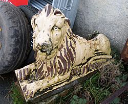
In the 1930s, people described Haining Place as an "Old World Mansion." It had a tall arched entrance with a weather vane and two lion statues. Locals even had a story that Mary, Queen of Scots once stayed there!
At that time, the building had two floors. The ground floor had three stone-vaulted rooms, which were used for storage. These rooms had very thick walls, like an old castle. The upper floor was reached by outside steps. Some people thought the upper floor was built on top of an older, ruined castle.
What Haining Place Looks Like Today (2015)
Today, the entrance arch and the lion statues are gone. The lions are now at Haining Mains Farm. You can still see the steps that led to the first floor, but most of the upper floor is missing.
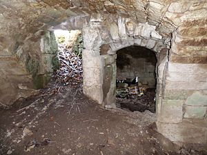
Inside, the three vaulted rooms on the ground floor are still there. You can see where windows were, some open and some blocked up. There are also parts of a spiral staircase. The building shows signs that it was improved over time, meaning it was adapted from a strong castle into a more comfortable home.
The Cable Bridge
For many years, the Cunninghame family lived at Haining Place. They were friends with the family at Braehead Farm nearby. To make it easier to visit, they built a simple "cable bridge" across the Cessnock Water. It used two steel cables: one to stand on and one to hold onto. This way, people could cross the river without getting their feet wet, even when the water was high!
Haining Mains Farm
Farms called "mains" were usually connected to large houses or mansions. They provided food and other supplies for the owners and their staff. Haining Mains Farm is clearly shown on the first OS maps from the 1850s.
An old stone above a door at Haining Mains has the initials 'J W' and the date '1829'. Records show the Wilson family lived there in the 1870s. The two stone lions that were once at the entrance of Haining Place are now at Haining Mains Farm.
People at Haining Place and Mains
In the 1850s, George Bowie was the tenant at Haining Place. Later, John Dunlop farmed there in 1868. In the 1890s, Haining Mains Farm was part of the Duke of Portland's estates, and David Shaw was the farmer. The last people to live at Haining Place itself were three families of farm workers. They later moved to new homes in Kilmarnock.
John Goudie of Craigmill (1717-1809)
John Goudie was born at Craigmill, the old mill of the Haining barony. When he was just 14, John built a working model of an advanced water mill. This model was so good that people gave him money to improve it!
John later moved to Kilmarnock and became a cabinet maker, then a wine merchant. But he was also very interested in science and religion. He wrote books, and one of his publications from 1780 became known as 'Goudie's Bible.'
John Goudie became friends with the famous Scottish poet Robert Burns. Burns even wrote a poem called 'Epistle to John Goldie,' which praised Goudie's ideas.
Craigmill, the old mill, was taken down by 1908, and not much of it remains today.
More Interesting Facts
- In 1931, a local walking group, the Kilmarnock Glenfield Ramblers, visited Haining Place. They saw that the Hurlford and District Angling Club was putting trout fish into the river.
- The Ramblers also noticed some rare plants growing at the site, like the Dusky Cranesbill and Toothwort.
- David Shaw of Haining Mains Farm was a pioneer in using milking machines for cows. In 1890, he and a Mr Murchland from Kilmarnock created one of the first successful milking machines.
- The nearby estate of Dallars might get its name from old Welsh words meaning "meadow" and "ploughed land." Its name was changed to 'Auchenskeith' for a while, but the old name 'Dallars' is now used again.
- Alison Begbie was a woman that Robert Burns is said to have proposed to. She was a farmer's daughter and worked at Carnell House, which was close to the Cessnock Water. She might have lived near Haining Place.
 | Audre Lorde |
 | John Berry Meachum |
 | Ferdinand Lee Barnett |


