
Hallowell Historic District facts for kids
Quick facts for kids |
|
|
Hallowell Historic District
|
|
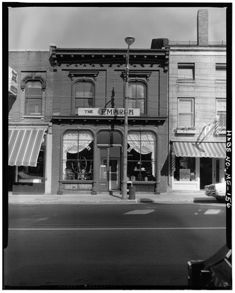
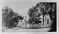
HABS photo of 154 Water Street
|
|

Location in Maine

Location in the United States
|
|
| Location | Hallowell, Maine |
|---|---|
| Area | 260 acres (110 ha) |
| Built | 1825-1899 |
| Architect | Alexander C. Currier; John Calvin Stevens; et al. |
| Architectural style | Federal, Mid 19th Century Revivals, Late Victorian |
| NRHP reference No. | 70000076, updated to 100001675 |
| Added to NRHP | October 28, 1970 |
The Hallowell Historic District is a special area in Hallowell, Maine, that shows off buildings from the 1700s and 1800s. Hallowell used to be a very busy port city on the Kennebec River. This means many ships came and went, bringing goods and people. Because of this, the downtown area and nearby homes grew a lot. More than half of the 400+ buildings in this district were built before 1865! This district was added to the National Register of Historic Places in 1970, which means it's recognized as an important historical place.
Exploring Hallowell's Past
Hallowell was first settled in the 1760s. The main street, Water Street (United States Route 201), follows the river and was once a path used by Native Americans. Two other important streets, Winthrop and Center Streets, were also planned early on.
At first, Hallowell was a farming community. But in the early 1800s, it became a big center for printing books and newspapers. Later, in the late 1800s, it was known for processing granite, a type of stone. Over time, the city of Augusta, which is just north of Hallowell, became more important. Augusta even became the state capital!
What's Inside the District?
The Hallowell Historic District is shaped like a rectangle. Its southern edge is at Litchfield Road, and its northern edge is near Page Street. The river forms the eastern border, and the western border follows streets like Middle, Warren, and Pleasant Streets.
This district includes about 450 buildings. Most of these were built before the year 1900. A surprising half of them were even built before 1865! You can find homes here, including the house of Joseph R. Bodwell, who was the Governor of Maine in 1875. A governor is the leader of a state. There are also many commercial buildings made of wood or stone. One of these, built in 1813, was home to the very first bookstore located east of Portland.
Historic Buildings to See
Here are some of the interesting buildings you can find in the Hallowell Historic District:
- Artemus Leonard House (around 1811)
- Capt. Samuel Watts House (1820)
- Old Fire Station (around 1830)
- Hallowell Cotton Mill (1844)
- Gage Row House (1846), which provided homes for textile workers
- Capt. Henry Cooper House (1850)
- St. Matthew's Episcopal Church (1860), designed by architect Richard Upjohn
- Hallowell Granite Company Headquarters (around 1870)
- Gov. Joseph R. Bodwell House (1875)
- Hubbard Free Library (1879–80), designed by architect Alexander C. Currier
- Old South Congregational Church (1885)
- Hallowell City Hall (1898)
- Johnson House (1899), designed by architect John Calvin Stevens
Gallery
-

Capt. Samuel Watts House (1820).
-
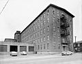
Hallowell Cotton Mill (1844).
-
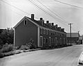
Gage Row House (1846).
-
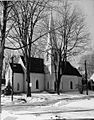
St. Matthew's Episcopal Church (1860).
-

Gov. Joseph R. Bodwell House (1875).
-
Hubbard Free Library (1879–80), Alexander C. Currier, architect.


