Hamilton Harbour facts for kids
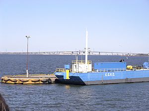
Hamilton Harbour, once called Burlington Bay, is a large body of water at the very west end of Lake Ontario. It's surrounded by the cities of Burlington and Hamilton. People in Hamilton often just call it "The Harbour" or "The Bay." Long ago, a natural sand bar separated the harbour from Lake Ontario. A channel was later dug through this sand bar so ships could easily pass through. The Port of Hamilton, a very busy shipping area, is located on the Hamilton side of the harbour. The harbour is also connected to Cootes Paradise by a narrow channel.
Contents
A Look Back: The History of Hamilton Harbour
How Hamilton Harbour Got Its Name
In 1792, John Graves Simcoe, who was the first leader of Upper Canada, named this water body Burlington Bay. He named it after a town in England called Bridlington. Before that, local Indigenous peoples called it Washquarter. Another early name given by Indigenous peoples was Macassa, which means "beautiful waters." In 1919, the name was officially changed from Burlington Bay to Hamilton Harbour.
Early Importance and Pollution
The harbour was very important for early travel and industry in the area. But over time, the harbour was not treated well. People filled in parts of it, especially in Hamilton's North End. This damaged fresh water streams and the animals living there. Digging channels for ships also stirred up dirt and pollution.
Chemicals, industrial waste, and hot water from factories, especially from the growing steel industry after the 1890s, made the water very dirty. By 1917, pollution became a big problem. Families living nearby faced health risks because sewage was dumped into the harbour. A book called An Environmental History of Canada mentions that as early as the 1860s, fish in the harbour tasted like coal oil, and dead animals were covered in oil from refineries. By the 1950s, the city decided Hamilton Harbour was too dirty for swimming and closed all the beaches.
Cleaning Up the Harbour
By the 1970s, groups like the International Joint Commission, which helps manage water use in the Great Lakes Basin, realized something had to be done. Over the next few decades, people became more aware of water quality. Better pollution controls and a slower economy helped improve conditions in the 1980s.
In the 1990s, efforts to make the harbour beautiful and healthy again were well underway. This included covering up contaminated areas with clay and creating Bayfront Park and Pier 4 Park. They also worked to keep certain fish, like common carp, out of Cootes Paradise to help native species.
A big moment showing the improvement was in 1994 when Sheila Copps, a local politician, publicly swam in the bay. Today, people can enjoy the harbourfront more, and swimming is allowed at two beaches: Bayfront and Pier 4.
Hamilton Harbour is listed as one of the "Great Lakes Areas of Concern" by an agreement between the United States and Canada. Part of the plan to fix the harbour is to bring back its natural wetlands. While most of the carp were removed by 2021, many goldfish have been found, likely from people dumping pet fish. Experts say goldfish are very tough and can survive in difficult conditions, even eating harmful algae blooms that native fish cannot.
Randle Reef: A Major Cleanup Project
Randle Reef is a spot in the southeast part of the harbour with a lot of pollution. It's considered one of Canada's most serious water pollution problems. This cleanup project involves building a special container, about the size of 7.5 football fields. Inside this container, they will put about 130,000 cubic meters of dirty mud, which is contaminated with harmful chemicals. They will also dredge (dig up) another 500,000 cubic meters of contaminated mud from around the area and place it inside the container.
The container was built in 2018 using strong steel walls. After the dirty mud is placed inside, any wastewater will be cleaned using a special treatment system before being released back into the harbour. Finally, a protective cap made of different layers of materials like gravel, fabric, and asphalt will be built over the container. This cap will keep the toxic mud safely contained for about 200 years.
This big cleanup project costs $138.9 million and was expected to be finished in 2022. The money comes from different groups, including the Canadian government, the Ontario government, the cities of Hamilton and Burlington, Halton Region, the Hamilton Port Authority, and Stelco.
Burlington Shipping Canal
The opening that connects Hamilton Harbour to Lake Ontario is called the Burlington Shipping Canal. It was first planned in 1824 and opened in 1826. The Burlington Canal Lift Bridge is a special bridge that lifts up to let ships pass over this canal.
Harbour Infrastructure
Today, two major highways cross the area around the bay: Highway 403 and the Queen Elizabeth Way (QEW). The Burlington Bay James N. Allan Skyway bridge, which is part of the QEW, crosses the water where Hamilton Harbour meets Lake Ontario. Highway 403, York Street, and several railway lines cross Hamilton Harbour on a natural sandbar. This sandbar separates Cootes Paradise from the main harbour. The harbour is also home to the Port of Hamilton, which is the busiest port on the Canadian Great Lakes. It handles over 10 million tonnes of cargo every year!
 | Bayard Rustin |
 | Jeannette Carter |
 | Jeremiah A. Brown |


