Harmony, Marinette County, Wisconsin facts for kids
Quick facts for kids
Harmony, Wisconsin
|
|
|---|---|
| Country | |
| State | |
| County | Marinette |
| Elevation | 213 m (699 ft) |
| Time zone | UTC-6 (Central (CST)) |
| • Summer (DST) | UTC-5 (CDT) |
| Area code(s) | 715 & 534 |
| GNIS feature ID | 1566072 |
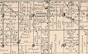
Harmony is a small, unincorporated community in Marinette County, Wisconsin, United States. It used to be called Harmony Corners. This community is part of the town of Grover. Harmony is located about 5 miles (8 km) northwest of a town called Peshtigo.
Where is Harmony Located?
Harmony sits at a spot where two county roads, Highway D and Highway DD, meet. It is about 699 feet (213 meters) above sea level. You can reach Harmony by road from Peshtigo to the southeast. You can also get there from Marinette to the east, by using Highway 64.
A place about 1.6 miles (2.6 km) west-northwest of Harmony was once known as Gould's Corners. This was where County Highway D and Highway 64 crossed paths. It was named after a farm owned by Addison Norris Gould, who lived from 1850 to 1925.
A Look Back in Time: Harmony's History
Harmony had its own post office starting in 1885. A man named James H. Potter (1827–1905) was the first postmaster. A postmaster is the person in charge of a post office. In the past, there was also a cheese factory operating in Harmony. This factory would have made cheese from milk produced by local farms.
 | James Van Der Zee |
 | Alma Thomas |
 | Ellis Wilson |
 | Margaret Taylor-Burroughs |


