
Harrietta, Michigan facts for kids
Quick facts for kids
Harrietta, Michigan
|
|
|---|---|
|
Village
|
|
| Village of Harrietta | |
.jpg)
Looking south along Davis Avenue
|
|

Location within Wexford County
|
|

Harrietta, Michigan
Location in Michigan

Harrietta, Michigan
Location in the United States
|
|
| Country | |
| State | |
| County | Wexford |
| Townships | Boon and Slagle |
| Settled | 1889 |
| Incorporated | 1891 |
| Government | |
| • Type | Village council |
| Area | |
| • Total | 0.99 sq mi (2.57 km2) |
| • Land | 0.99 sq mi (2.57 km2) |
| • Water | 0.00 sq mi (0.00 km2) |
| Elevation | 1,145 ft (349 m) |
| Population
(2020)
|
|
| • Total | 151 |
| • Density | 152.06/sq mi (58.72/km2) |
| Time zone | UTC-5 (Eastern (EST)) |
| • Summer (DST) | UTC-4 (EDT) |
| ZIP code(s) |
49638
|
| Area code(s) | 231 |
| FIPS code | 26-36720 |
| GNIS feature ID | 1620134 |
Harrietta is a small village located in Wexford County, Michigan, in the United States. In 2020, about 151 people lived there, making it one of the smallest villages in Michigan. It's split between two areas called Slagle Township and Boon Township.
Contents
History of Harrietta
Harrietta was first planned out in 1889. It was built along the Toledo, Ann Arbor and North Michigan Railway. An early founder, James Ashley, named it "Harriette." He combined his father's name, Harry, with his fiancé Henriette Burt's name.
In 1890, the Springdale post office moved to Harriette. This post office had been set up earlier in 1874. Even after moving, it kept its original name.
The community officially became a village in 1891 and was called "Gaston." However, railway leaders wanted the name changed back. So, in 1892, it returned to "Harriette." Finally, in 1925, the village and post office changed their name again to the current "Harrietta."
Harrietta's Location and Size
According to the U.S. Census Bureau, the village of Harrietta covers a total area of about 0.99 square miles (2.57 square kilometers). All of this area is land, with no water.
Harrietta's Population
The number of people living in Harrietta has changed over the years. You can see how the population has grown and shrunk in the table below.
| Historical population | |||
|---|---|---|---|
| Census | Pop. | %± | |
| 1890 | 335 | — | |
| 1900 | 419 | 25.1% | |
| 1910 | 336 | −19.8% | |
| 1920 | 226 | −32.7% | |
| 1930 | 149 | −34.1% | |
| 1940 | 208 | 39.6% | |
| 1950 | 112 | −46.2% | |
| 1960 | 119 | 6.3% | |
| 1970 | 132 | 10.9% | |
| 1980 | 139 | 5.3% | |
| 1990 | 157 | 12.9% | |
| 2000 | 169 | 7.6% | |
| 2010 | 143 | −15.4% | |
| 2020 | 151 | 5.6% | |
| U.S. Decennial Census | |||
Harrietta's People in 2010
In 2010, there were 143 people living in Harrietta. These people lived in 60 different homes, and 40 of those were families.
Most of the people in the village (94.4%) were White. A small number were African American (0.7%) or Asian (0.7%). About 4.2% of the population identified as being of two or more races. Also, 4.2% of the people were Hispanic or Latino.
In terms of age, the average age in the village was 46.1 years old.
- About 21% of the residents were under 18 years old.
- About 4.2% were between 18 and 24 years old.
- About 23.1% were between 25 and 44 years old.
- About 34.3% were between 45 and 64 years old.
- About 17.5% were 65 years old or older.
More males lived in the village than females in 2010. About 53.8% of the population was male, and 46.2% was female.
Images for kids
-
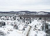
Aerial view in December 2017 -
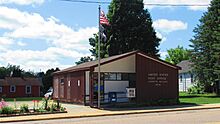
U.S. Post Office in Harrietta -
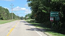
Road signage along Slagle Street -
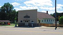
Harrietta Village Hall


See also
 In Spanish: Harrietta (Míchigan) para niños
