Harrisonville, New Jersey facts for kids
Quick facts for kids
Harrisonville, New Jersey
|
|
|---|---|

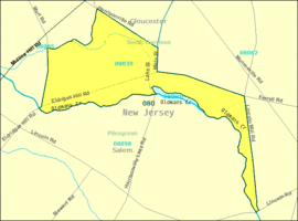
United States Census Bureau map of Harrisonville, New Jersey
|
|
| Country | |
| State | |
| County | Gloucester |
| Township | South Harrison |
| Area | |
| • Total | 2.03 sq mi (5.25 km2) |
| • Land | 2.00 sq mi (5.19 km2) |
| • Water | 0.02 sq mi (0.06 km2) |
| Elevation | 82 ft (25 m) |
| Population
(2020)
|
|
| • Total | 306 |
| • Density | 152.77/sq mi (58.99/km2) |
| ZIP Code |
08039
|
| FIPS code | 34-30270 |
| GNIS feature ID | 0876971 |
Harrisonville is a small community located in Gloucester County, in the state of New Jersey. It is part of South Harrison Township.
Harrisonville is known as an "unincorporated community." This means it doesn't have its own separate local government like a city or town. Instead, it's governed as part of the larger South Harrison Township. It's also a "census-designated place" (CDP), which is an area defined by the government just for counting people during the census. This helps them collect important information about the population.
The community uses the United States Postal Service ZIP Code 08039 for mail.
Population and People
How Many People Live Here?
The number of people living in Harrisonville has changed over time. In the year 2000, about 153 people lived in the area covered by ZIP Code 08039.
Recent Population Count
According to the most recent count, the 2020 United States census, the population of Harrisonville was 306 people. This shows that the community has grown since the 2000 census.
| Historical population | |||
|---|---|---|---|
| Census | Pop. | %± | |
| 2020 | 306 | — | |
| U.S. Decennial Census | |||
 | Jessica Watkins |
 | Robert Henry Lawrence Jr. |
 | Mae Jemison |
 | Sian Proctor |
 | Guion Bluford |


