Hartleton, Pennsylvania facts for kids
Quick facts for kids
Hartleton, Pennsylvania
|
|
|---|---|
|
Borough
|
|

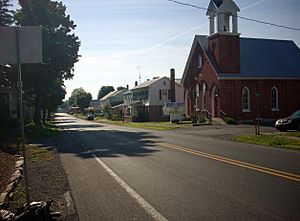
Pennsylvania Route 45 passes through Hartleton
|
|

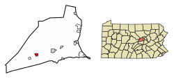
Location of Hartleton in Union County, Pennsylvania.
|
|
| Country | United States |
| State | Pennsylvania |
| County | Union |
| Settled 1775 | 1798-1799 town laid out |
| Incorporated (borough) | September 18,1858 |
| Area | |
| • Total | 0.91 sq mi (2.35 km2) |
| • Land | 0.91 sq mi (2.35 km2) |
| • Water | 0.00 sq mi (0.00 km2) |
| Elevation
(center of borough)
|
650 ft (200 m) |
| Highest elevation
(western borough boundary by Harleton Cemetery)
|
760 ft (230 m) |
| Lowest elevation
(Cold Run at southeast borough boundary)
|
610 ft (190 m) |
| Population
(2020)
|
|
| • Total | 251 |
| • Density | 276.43/sq mi (106.69/km2) |
| Time zone | Eastern (EST) |
| • Summer (DST) | EDT |
| Zip code |
17829
|
| Area code(s) | 570 |
| FIPS code | 42-32936 |
Hartleton is a small town, also called a borough, located in Union County, Pennsylvania. In 2020, about 247 people lived there. Both Hartleton and the nearby Hartley Township are named after Colonel Thomas Hartley. He was an important American politician and a leader during the American Revolutionary War. He also owned land in this area.
The town was first called Kester's, after Peter Kester, who was the first person to rent land from Hartley. The name was later changed to Hartleyton and then shortened to Hartleton. Colonel Hartley bought the land in 1784. He started planning the town as early as 1798, and the first piece of land was sold in 1799.
Where is Hartleton?
Hartleton is located in Pennsylvania at these coordinates: 40.900148 degrees North and -77.155229 degrees West.
The United States Census Bureau says that the borough covers a total area of about 0.9 square miles (2.3 square kilometers). All of this area is land.
People in Hartleton
| Historical population | |||
|---|---|---|---|
| Census | Pop. | %± | |
| 1870 | 292 | — | |
| 1880 | 300 | 2.7% | |
| 1890 | 261 | −13.0% | |
| 1900 | 237 | −9.2% | |
| 1910 | 160 | −32.5% | |
| 1920 | 161 | 0.6% | |
| 1930 | 169 | 5.0% | |
| 1940 | 208 | 23.1% | |
| 1950 | 240 | 15.4% | |
| 1960 | 234 | −2.5% | |
| 1970 | 223 | −4.7% | |
| 1980 | 220 | −1.3% | |
| 1990 | 246 | 11.8% | |
| 2000 | 260 | 5.7% | |
| 2010 | 283 | 8.8% | |
| 2020 | 247 | −12.7% | |
| 2021 (est.) | 248 | −12.4% | |
| Sources: | |||
In the year 2000, there were 260 people living in Hartleton. These people made up 89 households, and 71 of those were families. The population density was about 286 people per square mile.
Most of the people living in Hartleton were White (97.31%). A small number (2.69%) were from two or more racial backgrounds. About 0.38% of the population identified as Hispanic or Latino.
Households and Families
Out of the 89 households in 2000:
- About 33.7% had children under 18 living with them.
- About 65.2% were married couples living together.
- About 10.1% had a female head of the household with no husband present.
- About 20.2% were not families.
Also, 19.1% of all households were made up of single individuals. About 14.6% of these individuals were 65 years old or older and lived alone. On average, there were 2.72 people in each household and 3.11 people in each family.
Age Groups
The people in Hartleton were spread out across different age groups:
- 27.7% were under 18 years old.
- 6.2% were between 18 and 24 years old.
- 26.9% were between 25 and 44 years old.
- 26.2% were between 45 and 64 years old.
- 13.1% were 65 years old or older.
The average age of people in the borough was 37 years. For every 100 females, there were about 104.7 males. For every 100 females aged 18 and over, there were about 97.9 males.
See also
 In Spanish: Hartleton para niños
 | Misty Copeland |
 | Raven Wilkinson |
 | Debra Austin |
 | Aesha Ash |


