Hatcher Pass facts for kids
Quick facts for kids Hatcher Pass |
|
|---|---|
 |
|
| Elevation | 3,886 ft (1,184 m) |
| Location | Matanuska-Susitna Borough, Alaska, United States |
| Range | Talkeetna Mountains |
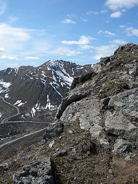
Hatcher Pass is a beautiful mountain pass located in the southwest part of the Talkeetna Mountains in Alaska. It sits at an elevation of 3,886 feet (1,148 meters). The pass was named after Robert Hatcher, who was a prospector and miner. The closest cities are Palmer and Wasilla, which are about 12 miles (19 km) to the south. Willow is about 26 miles (42 km) to the west. These towns are in the Mat-Su Valley, at an elevation of about 250 feet (76 meters).
Contents
Exploring Hatcher Pass: A Scenic Drive
You can reach Hatcher Pass from the west by taking a road from the Parks Highway. This road winds about 40 miles (64 km) up the Willow Creek valley. The pass separates the high mountain streams of Willow Creek on the west side from Fishhook Creek and Independence Bowl on the east side.
As you go east, the road goes down into the Little Susitna River canyon. It follows the river south for about 12 miles (19 km) until it reaches the wide Matanuska-Susitna Valley. About 20 miles (32 km) of the road over the pass is unpaved and not always perfectly maintained. This central part of the road is usually closed by snow from late September until July. Even when it's closed to cars, many people use it for snowmobiling and skiing in winter and spring.
Long ago, in the early 1900s, there were many mines, tunnels, and sky-trams in this area. These mining activities are why the road was built. Today, only a few people live and work in Independence Bowl. No one lives in the surrounding valleys anymore.
History of Hatcher Pass: Gold and Native Lands
There are no known historical settlements of native people right in the Hatcher Pass area. However, Dena'ina Indians hunted animals like caribou, sheep, and moose in the western Talkeetna Mountains until the 1930s. Almost all the development in this area, including the road, happened because of gold mining.
Most of the land around the pass is public land. There are a few small private properties, mainly for mining.
Fun Things to Do at Hatcher Pass
Hatcher Pass is a very popular place for a day trip or longer adventures. People enjoy many activities here:
- Sledding
- Skiing
- Snowmobiling
- Hiking
- Camping
- Hunting
- White-water kayaking
- Berry-picking
- Climbing
- Recreational gold-mining
- Mountain biking
Independence Mine State Historic Park is a few miles east of the pass. It covers 271 acres (1.1 km²) and has well-preserved mine buildings. There's also a mining museum that offers tours of an underground mine. A large area called the Hatcher Pass State Management Area includes and surrounds the State Park and the pass itself.
You can find food and a place to stay at The Hatcher Pass Lodge in Independence Valley.
Skiing Adventures
Hatcher Pass has a long history of skiing. Old photos show miners skiing for fun. In the 1930s, skiers from Anchorage would take buses to the Fishhook Inn to use its rope tow. Several small rope-tow ski lifts operated near the pass until the 1960s, but only traces of them remain today. There have been many ideas over the years to build a modern ski resort here. In 2005, the Mat-Su Borough even added electricity and built a short road to a proposed base lodge site.
The pass is one of the most popular places in Alaska for backcountry skiing that you can reach by road. It's usually the first area near cities in Alaska to get enough snow for skiing in the fall. The backcountry alpine skiing season typically runs from late September to late April.
There are also groomed trails for cross-country skiing (skate and diagonal styles) near the Hatcher Pass Lodge and the museum. These trails wind among the old mining buildings in the high mountain area. Their season usually lasts from October to April.
At the Government Peak Recreation Area, a few miles south of Hatcher Pass, the first 10 kilometers (6.2 miles) of Nordic ski trails opened in December 2012. A chalet was built there in 2013. More trails and lighting are planned for the future.
Snowmobiles are not allowed in large parts of the Hatcher Pass State Management Area where skiers often go. There are also several backcountry huts in the area. You can even travel a wilderness loop over the mountain passes and glaciers, connecting these huts.
Gold Mining History
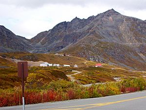
The Willow Creek mining district at Hatcher Pass is historically the third-largest gold-producing area in Alaska from hard rock mines. It has produced 624,000 ounces of gold! People started mining for placer gold (gold found in riverbeds) in the Willow Creek mining district in 1906. Hardrock gold mining (from veins in rocks) began a few years later. Placer mining for gold still happens sometimes today.
Underground mining continued in different places around the pass until 1951. In the 1980s, one of the hard-rock mines in the area was briefly reopened. At least one mining company is still looking for gold in the area today.
Geography and Landscape
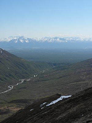
The Fishhook Road climbs to 3,886 feet (1,184 meters) to cross Hatcher Pass. This is where Fishhook and Willow Creeks begin in the southwestern part of the Talkeetna Mountains. The area was shaped a lot by glaciers. You'll see steep-walled cirques (bowl-shaped hollows), jagged aretes (sharp ridges), and hanging valleys above U-shaped valleys.
Trees only grow in the lowest parts of the valleys. Bushes, which can be very thick, grow on the lower mountain slopes. As you go higher, the land changes to open tundra. Glaciers are found at the very tops of the main river systems. Some nearby mountain peaks are over 6,000 feet (1,829 meters) tall.
Mountain Biking Trails
The Gold Mint Trail offers many miles of challenging mountain biking. It's rocky and climbs gently alongside the Little Susitna River. The "16-mile trail" is a steep downhill bike trail, about 2 miles (3 km) long, with a 1,000-foot (305-meter) drop. It was built in 2013 between the switchbacks of the Hatcher Pass road, starting at mile 16.
At Government Peak Recreational Area, a few miles south of Hatcher Pass, there are 5.5 miles (8.9 km) of singletrack bike trails. These trails are designed with berms (banked turns) for a fun, flowing ride.
Wildlife Watching
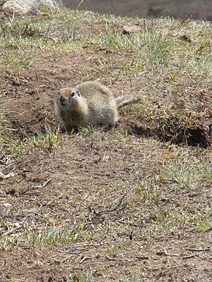
Hatcher Pass is a great place for wildlife viewing. You might spot animals like the Arctic ground squirrel and other creatures that live in this beautiful mountain environment.
 | Chris Smalls |
 | Fred Hampton |
 | Ralph Abernathy |


