Wasilla, Alaska facts for kids
Quick facts for kids
Wasilla
Benteh
|
|||
|---|---|---|---|
|
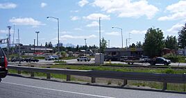
View of Main Street from the Parks Highway
Wasilla City Hall
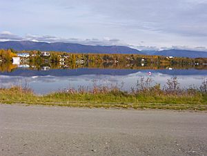
Wasilla Lake seen from the Parks Highway
Iditarod headquarters sign
Wasilla Depot
|
|||
|
|||
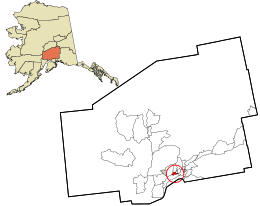
Location in Matanuska-Susitna Borough and the state of Alaska.
|
|||
| Country | United States | ||
| State | Alaska | ||
| Borough | Matanuska-Susitna | ||
| Incorporated | February 26, 1974 | ||
| Area | |||
| • Total | 13.13 sq mi (34.01 km2) | ||
| • Land | 12.40 sq mi (32.10 km2) | ||
| • Water | 0.73 sq mi (1.90 km2) | ||
| Elevation | 341 ft (104 m) | ||
| Population
(2020)
|
|||
| • Total | 9,054 | ||
| • Density | 730.40/sq mi (282.01/km2) | ||
| Time zone | UTC−9 (Alaska (AKST)) | ||
| • Summer (DST) | UTC−8 (AKDT) | ||
| ZIP codes |
99629, 99654, 99687
|
||
| Area code | 907 | ||
| FIPS code | 02-83080 | ||
| GNIS feature ID | 1411788 | ||
| Website | cityofwasilla.gov | ||
Wasilla is a city in Alaska, United States. It is the fourth-largest city in the state. Wasilla is located in the Matanuska-Susitna Valley, which is in the southcentral part of Alaska.
The city's population was 9,054 in 2020. Wasilla is the biggest city in its borough and is part of the larger Anchorage metropolitan area.
Wasilla started where the Alaska Railroad met the Old Carle Wagon Road. It grew as a supply center for nearby mines. Over time, its economy changed. It went from farming and recreation to supporting people who work in Anchorage or on Alaska's oilfields. The George Parks Highway helped Wasilla become a place where people live and commute to Anchorage for work.
Wasilla is also famous as the home of the Iditarod Trail Sled Dog Race headquarters. This is a very popular and important sporting event in Alaska. The city also gained international attention when Sarah Palin, who was once the Mayor of Wasilla, became a candidate for Vice President of the United States in 2008.
The name "Wasilla" comes from Chief Wasilla. He was a local Dena'ina chief. "Wasilla" is the English way of spelling his Russian name, Vasilij, which means Basil.
Contents
History of Wasilla
Long ago, huge sheets of ice covered much of the northern world. These ice sheets melted away between 10,000 and 7,000 years ago. Early humans traveled through this area, leaving signs of their presence.
The Dena'ina Alaska natives eventually settled the Matanuska-Susitna valley. They used the fertile land and fished in Cook Inlet. The Dena'ina are one of many Native Alaskan groups. The area where downtown Wasilla is now was called Benteh by the Dena'ina. This means "among the lakes."
How Wasilla Grew
Around 1880, the town of Knik was settled near the Matanuska River. In 1900, gold mining began in the Willow Creek Mining District to the north. Knik became a busy mining town.
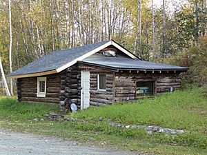
In 1917, the U.S. government planned the Alaska Railroad. It was designed to cross the Carle Wagon Road. This road connected Knik to the mines. Businesses and people quickly bought land near this new railroad crossing. Because of this, Knik started to shrink, and Wasilla grew.
Wasilla Station was named after Wasilla Creek. Local miners used the name "Wasilla Creek" after Chief Wasilla, a Dena'ina chief. Some say the name means "breath of air" in Dena'ina. Others say it comes from the Russian name Vasilij.
As Knik became a ghost town, Wasilla became a supply center. It helped fur trappers and miners working in the gold fields. In 1935, over 200 farm families moved to the Matanuska and Susitna valleys. This was part of a U.S. government plan to start new farming communities.
Modern Wasilla
Wasilla was a supply base for gold mines until after World War II. Until the George Parks Highway was built around 1970, nearby Palmer was the main city in the Matanuska Valley. The Parks Highway changed everything. It made Wasilla a major stop on the highway and railroad. This road connects Southcentral Alaska to Interior Alaska.
Because of the new highway, more people moved to Wasilla. The city grew quickly. Wasilla officially became a city in 1974.
In 2008, the Iditarod Trail Sled Dog Race had to change its starting point. Less snow in Wasilla due to a warming climate meant the race had to move. From 1973 to 2002, the race started in Wasilla. Now, it starts in Willow, Alaska.
Geography of Wasilla
Wasilla covers about 12.4 square miles (32.2 km2). Most of this area is land, with a small part being water.
The city is located near Wasilla Lake and Lake Lucille. Wasilla is one of two main towns in the Matanuska-Susitna Valley. It is about 43 miles (69 km) northeast of Anchorage by highway. Many people who live in Wasilla drive to Anchorage for work every day. Mount POW/MIA is also nearby.
Climate in Wasilla
Wasilla has a climate similar to Anchorage. It is a subarctic climate. This means it has cold winters and mild summers.
- On average, Wasilla has about 30-31 days a year where the temperature drops below 0°F (–18°C).
- It also has about 37-38 days a year where the temperature reaches 70°F (21°C) or higher.
- The city gets about 17 inches (432 mm) of rain each year.
- It also gets about 52 inches (1.3 m) of snow each year.
| Climate data for Wasilla, Alaska | |||||||||||||
|---|---|---|---|---|---|---|---|---|---|---|---|---|---|
| Month | Jan | Feb | Mar | Apr | May | Jun | Jul | Aug | Sep | Oct | Nov | Dec | Year |
| Mean daily maximum °F (°C) | 23.7 (−4.6) |
28.6 (−1.9) |
36.9 (2.7) |
49.1 (9.5) |
61.1 (16.2) |
67.7 (19.8) |
69.6 (20.9) |
67.4 (19.7) |
58.6 (14.8) |
42.9 (6.1) |
28.2 (−2.1) |
25.7 (−3.5) |
46.7 (8.2) |
| Mean daily minimum °F (°C) | 8.2 (−13.2) |
11.8 (−11.2) |
18.8 (−7.3) |
28.2 (−2.1) |
36.7 (2.6) |
44.5 (6.9) |
49.2 (9.6) |
46.8 (8.2) |
39.7 (4.3) |
26.9 (−2.8) |
13.2 (−10.4) |
10.1 (−12.2) |
27.9 (−2.3) |
| Average precipitation inches (mm) | 0.8 (20) |
0.9 (23) |
0.5 (13) |
0.7 (18) |
0.8 (20) |
1.6 (41) |
2.5 (64) |
2.7 (69) |
2.7 (69) |
1.8 (46) |
1.2 (30) |
1.0 (25) |
17.2 (440) |
| Average snowfall inches (cm) | 8.4 (21) |
8.9 (23) |
5.8 (15) |
2.5 (6.4) |
0.1 (0.25) |
0 (0) |
0 (0) |
0 (0) |
0 (0) |
4.7 (12) |
8.7 (22) |
12.8 (33) |
52.1 (132) |
| Source: NOAA (1981–2010 normals), Weatherbase (precip, snow) | |||||||||||||
People of Wasilla
| Historical population | |||
|---|---|---|---|
| Census | Pop. | %± | |
| 1930 | 51 | — | |
| 1940 | 96 | 88.2% | |
| 1950 | 97 | 1.0% | |
| 1960 | 112 | 15.5% | |
| 1970 | 300 | 167.9% | |
| 1980 | 1,559 | 419.7% | |
| 1990 | 4,028 | 158.4% | |
| 2000 | 5,469 | 35.8% | |
| 2010 | 7,831 | 43.2% | |
| 2020 | 9,054 | 15.6% | |
| U.S. Decennial Census | |||
Wasilla first appeared on the U.S. Census in 1930 with 51 residents. It has grown steadily since then. In 2000, there were 5,469 people living in Wasilla. About 33.6% of the population was under 18 years old.
Economy in Wasilla
Wasilla started as a center for transportation and trade. It supported mining, trapping, and timber industries. Later, it became a farming community.
Around 1975, the Parks Highway was built. This road made it much faster to travel to Anchorage, which is about 43 miles away. Because of this, Wasilla became a "bedroom community." This means many people live in Wasilla but travel to Anchorage for work.
About 35% of the people who work in Wasilla commute to Anchorage. The local economy has many different types of jobs. People work for the city, the borough, the state, and the federal government. There are also jobs in retail and other services. Tourism, farming, wood products, steel, and concrete products are also part of the economy.
Fun Things to Do in Wasilla
The Museum of Alaska Transportation and Industry is in Wasilla. It was started in 1967. The museum shows the history of transportation and industry in Alaska. It tells the stories of the people and machines that helped Alaska grow.
Getting Around Wasilla
The George Parks Highway and the Glenn Highway connect Wasilla to Anchorage. They also connect to communities on the Kenai Peninsula. The Parks Highway also links the Matanuska Valley north to the rest of Alaska and Canada. The Alaska Railroad also serves Wasilla.
Wasilla has its own airport, called Wasilla Airport. It has a paved runway that is 3,700 feet (1,128 m) long. This airport offers air taxi services. In 2005, an "anti-moose mat" was put around the runway. This mat gives a small shock to animals like moose. It stops them from walking onto the runway where planes are moving. The old airport site is now a city park.
Wasilla also has eight public seaplane bases on nearby lakes. These are for planes that can land on water. There are also many private airfields in the area.
Parks and Outdoor Fun
The City of Wasilla has several parks. These include a large campground, a boat launch, and a dog park on Lake Lucille. There is also Newcomb Park on Wasilla Lake. Other parks have playgrounds and a skate park.
Alaska State Parks manages the Finger Lake State Recreation Area. They also manage the Little Susitna River Public Use Area. This area has a large campground and river access. It is also the entrance to a 300,800-acre public game reserve.
Wasilla in Movies and TV
Wasilla was one of five cities shown in the first season of the ABC reality show Emergency Call. This show follows real 9-1-1 calls and the people who answer them. Wasilla was also the setting for the MTV reality show Slednecks.
Famous People from Wasilla
- Troy Adams (born 1961), an interior designer.
- Chad Carpenter (born around 1968), a cartoonist who created the comic strip Tundra.
- Larry Csonka (born 1946), a famous former football player for the Miami Dolphins.
- David Eastman (born 1981), a state legislator.
- John Gourley (born 1981), the lead singer of the band Portugal.The Man.
- Lyda Green (born 1938), a former president of the Alaska Senate.
- Levi Johnston (born 1990), a media personality.
- Lisa Kelly (born 1980), from the TV show Ice Road Truckers.
- Vic Kohring (born 1958), a former state legislator.
- Tom Mechler (born 1956), a former chairman of the Republican Party of Texas.
- Dorothy G. Page (1921–1989), known as the "mother" of the Iditarod Trail sled dog race.
- Members of the Palin family:
- Sarah Palin (born 1964), a former mayor of Wasilla and former Alaska governor. She was also a candidate for Vice President in 2008.
- Todd Palin (born 1964), a professional snowmobile racer and four-time champion of the Iron Dog race.
See also
 In Spanish: Wasilla para niños
 | Bessie Coleman |
 | Spann Watson |
 | Jill E. Brown |
 | Sherman W. White |


