
Kenai Peninsula facts for kids
The Kenai Peninsula (called Yaghenen in the Dena'ina language) is a large piece of land that sticks out from the coast of Southcentral Alaska. The name Kenai comes from "Kenaitze," which is the name of the Native Athabascan Alaskan tribe, the Kahtnuht’ana Dena’ina. These people, whose name means "People along the Kahtnu (Kenai River)," have lived in this area for a very long time. They called the Kenai Peninsula Yaghanen, meaning "the good land."
Contents
Exploring the Kenai Peninsula
The Kenai Peninsula stretches about 150 miles southwest from the Chugach Mountains, which are south of Anchorage. It's like a giant finger of land. On its west side, it's separated from the mainland by Cook Inlet, and on its east side, by Prince William Sound. Most of this peninsula is part of the Kenai Peninsula Borough.
Native groups like the Athabaskan and Alutiiq people lived here for thousands of years. The first European to explore and map the area was Gerasim Izmailov in 1789.
Mountains, Lakes, and Rivers
Along the southeast coast, facing the Gulf of Alaska, you'll find the Kenai Mountains. These mountains are covered in glaciers and can reach up to 7,000 feet high! A big part of these mountains is protected within Kenai Fjords National Park.
The northwest coast, along Cook Inlet, is flatter and has many marshy areas with small lakes. Deeper inside the peninsula, there are several larger lakes, such as Skilak Lake and Tustumena Lake.
The peninsula is also home to famous rivers. The Kenai River is well-known for its huge salmon population. Its smaller branch, the Russian River, is also popular. Other rivers include the Kasilof River and the Anchor River. Kachemak Bay, a smaller inlet off Cook Inlet, extends into the southwest part of the peninsula. Much of this area is part of Kachemak Bay State Park.
Glaciers and Icefields
The eastern and southern parts of the Kenai Peninsula have many glaciers. It's home to two huge icefields: the Sargent Icefield and the Harding Icefield. Many glaciers flow out from these giant sheets of ice.
Towns and Cities of Kenai
The Kenai Peninsula has several important towns in Southcentral Alaska.
- Seward is on the Gulf of Alaska coast.
- Soldotna, Kenai, Sterling, and Cooper Landing are located along the Cook Inlet and Kenai River.
- Homer is found along Kachemak Bay.
There are also many smaller villages and settlements across the peninsula.
Getting Around the Peninsula
Homer is famous because it's where the paved highway system of North America ends. This makes it a very popular spot for people who drive all the way to Alaska from the lower 48 states.
Seward is the southern end point for the Alaska Railroad. If you want to fly, there are airports with regular flights in Kenai and Homer. Smaller airports for general aviation are in Soldotna and Seward.
The Seward Highway connects Seward to Anchorage, and the Sterling Highway is the main road that links the larger towns on the Kenai Peninsula to Anchorage. You can also find water taxi services and scheduled ferries operating out of Seward and Homer.
Kenai's Climate
The coastal areas of the Kenai Peninsula have a fairly mild climate. It gets a lot of rain, which is good for plants. In fact, it's one of the few places in Alaska where farming is possible. The growing season is long enough to produce hay and other crops.
Economy and Natural Resources
The Kenai Peninsula is rich in natural resources. It has deposits of natural gas, petroleum (oil), and coal. There are also many opportunities for both commercial fishing (for businesses) and personal fishing (for fun).
Tourism is a very important industry here. Many businesses offer guiding services for hunters and fishers. The Kenai Peninsula is often called "Alaska's Playground" because there's so much to do outdoors. The Kenai National Wildlife Refuge covers nearly two million acres of the peninsula, protecting its amazing wildlife and landscapes.
Images for kids
-
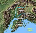
The Kenai Peninsula in Alaska
-
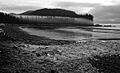
Kenai Peninsula Outer Coast
-
Kenai River
-
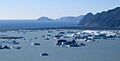
Kenai Peninsula Bear Glacier Lake and Pacific Ocean
-
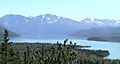
The Kenai River and Mountains, August 2003


See also
 In Spanish: Península de Kenai para niños
