
Cooper Landing, Alaska facts for kids
Quick facts for kids
Cooper Landing, Alaska
|
|
|---|---|

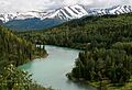
Cooper Landing below Cecil Rhode Mountain
|
|

Cooper Landing, Alaska
Location in Alaska
|
|
| Country | United States |
| State | Alaska |
| Borough | Kenai Peninsula |
| Area | |
| • Total | 69.84 sq mi (180.87 km2) |
| • Land | 65.75 sq mi (170.29 km2) |
| • Water | 4.09 sq mi (10.58 km2) |
| Elevation | 410 ft (123 m) |
| Population
(2020)
|
|
| • Total | 344 |
| • Density | 5.23/sq mi (2.02/km2) |
| Time zone | UTC-9 (AKST) |
| • Summer (DST) | UTC-8 (AKDT) |
| ZIP code |
99572
|
| Area code(s) | 907 |
| FIPS code | 02-17190 |
| GNIS feature ID | 1421192 |
Cooper Landing is a small community in Alaska, United States. It's located about 100 miles (160 km) south of Anchorage. This place sits where Kenai Lake flows into the Kenai River.
People first settled here in the 1800s, looking for gold and other minerals. Today, Cooper Landing is a popular spot for tourists in the summer. Visitors come for its beautiful scenery and to fish for salmon in the Kenai River and Russian River. In 2020, about 344 people lived in Cooper Landing.
Contents
History of Cooper Landing
Cooper Landing is named after Joseph Cooper. He was a miner who found gold here in 1884. But even before that, in 1848, a Russian engineer named Peter Doroshin had already noticed gold in the area. At that time, Alaska was still part of Russian America.
.jpeg)
The U.S. Geological Survey officially recorded Cooper Creek in 1898. By 1900, a census showed 21 miners and one wife living there. The first post office, called Riddiford, opened in 1924. A school, the Riddiford School, followed in 1928.
Roads were built to connect Cooper Landing to other towns. In 1938, a road went east to Seward. By 1948, a road west to Kenai was open. And by 1951, people could drive north all the way to Anchorage. The community also formed the Cooper Landing Community Club in 1949. A power plant, the Cooper Lake Hydroelectric Facility, was built between 1959 and 1960.
In 1946, Pat and Helen Gwin moved to Cooper Landing. Back then, only about 100 people lived there. The Gwins started a small store in a tent to make a living. That same year, work began on a highway from Cooper Landing to Homer. The Sterling Highway, a main road for the Kenai Peninsula, opened in 1950. The Seward Highway opened a year later in 1951.
The Gwins built their lodge using spruce logs from the nearby Chugach National Forest. They cut, hauled, and peeled the logs by hand. Gwin's Lodge opened on January 1, 1952. Helen Gwin continued to run the lodge until she retired in 1976. Today, Gwin's Lodge is one of Alaska's oldest log roadhouses and is still open.
The Cooper Landing Post Office is the oldest building in the area that is still in use. It is listed on the National Register of Historic Places because of its historical importance.
Geography and Location
Cooper Landing is in the northern part of the Kenai Peninsula. It is located at 60°29′26″N 149°47′40″W. The main part of the community is at the western end of Kenai Lake. This is where the lake's water flows into the Kenai River.

The area of Cooper Landing stretches east along Kenai Lake. To the south, it reaches Cooper Lake and Cooper Creek. To the west, it follows the Kenai River down to the Russian River. To the north, it goes up the valley of Juneau Creek. The land here ranges from about 330 feet (100 meters) above sea level near the Russian River to 4,576 feet (1,395 meters) at the top of Cecil Rhode Mountain.
Alaska Route 1, also known as the Sterling Highway, runs through Cooper Landing. This highway goes north 102 miles (164 km) to Anchorage. It also goes southwest 120 miles (193 km) to Homer. Soldotna, the main town of the Kenai Peninsula Borough, is 45 miles (72 km) west. Seward is 47 miles (76 km) southeast.
The total area of Cooper Landing is about 69.8 square miles (180.9 square kilometers). Most of this area, about 65.75 square miles (170.3 square kilometers), is land. The rest, about 4.09 square miles (10.6 square kilometers), is water.
Climate
Cooper Landing has a subarctic climate. This means it has long, cold winters and short, cool summers.
| Climate data for Cooper Landing | |||||||||||||
|---|---|---|---|---|---|---|---|---|---|---|---|---|---|
| Month | Jan | Feb | Mar | Apr | May | Jun | Jul | Aug | Sep | Oct | Nov | Dec | Year |
| Record high °F (°C) | 58 (14) |
59 (15) |
51 (11) |
64 (18) |
73 (23) |
78 (26) |
80 (27) |
81 (27) |
71 (22) |
64 (18) |
55 (13) |
52 (11) |
81 (27) |
| Mean daily maximum °F (°C) | 35 (2) |
36.9 (2.7) |
38.9 (3.8) |
45.6 (7.6) |
52.5 (11.4) |
58.3 (14.6) |
61.2 (16.2) |
61.3 (16.3) |
55.3 (12.9) |
46.7 (8.2) |
39 (4) |
36.5 (2.5) |
47.3 (8.5) |
| Mean daily minimum °F (°C) | 25 (−4) |
26.8 (−2.9) |
27.8 (−2.3) |
33.6 (0.9) |
39.8 (4.3) |
46.2 (7.9) |
50.2 (10.1) |
49.8 (9.9) |
44.3 (6.8) |
36.5 (2.5) |
30 (−1) |
26.8 (−2.9) |
36.4 (2.4) |
| Record low °F (°C) | −4 (−20) |
−2 (−19) |
−13 (−25) |
3 (−16) |
23 (−5) |
34 (1) |
35 (2) |
35 (2) |
28 (−2) |
16 (−9) |
4 (−16) |
−23 (−31) |
−23 (−31) |
| Average precipitation inches (mm) | 12.99 (330) |
11.64 (296) |
10.08 (256) |
9.95 (253) |
11.13 (283) |
6.69 (170) |
9.25 (235) |
13.41 (341) |
22.09 (561) |
20.97 (533) |
14.65 (372) |
16.72 (425) |
159.57 (4,053) |
| Average snowfall inches (cm) | 24.2 (61) |
21.7 (55) |
21.7 (55) |
5.9 (15) |
0.1 (0.25) |
0 (0) |
0 (0) |
0.2 (0.51) |
0 (0) |
1.8 (4.6) |
10.4 (26) |
25.3 (64) |
111.3 (283) |
| Average precipitation days | 16 | 15 | 15 | 15 | 17 | 15 | 17 | 17 | 21 | 21 | 18 | 19 | 206 |
Population and People
| Historical population | |||
|---|---|---|---|
| Census | Pop. | %± | |
| 1950 | 60 | — | |
| 1960 | 88 | 46.7% | |
| 1970 | 31 | −64.8% | |
| 1980 | 116 | 274.2% | |
| 1990 | 243 | 109.5% | |
| 2000 | 369 | 51.9% | |
| 2010 | 289 | −21.7% | |
| 2020 | 344 | 19.0% | |
| U.S. Decennial Census | |||
Cooper Landing first appeared on the U.S. Census in 1950. It was listed as a small, unincorporated village. In 1980, it became a "census-designated place" (CDP). This means it's an area identified by the Census Bureau for statistical purposes.

In 2000, there were 369 people living in Cooper Landing. There were 162 households, which are groups of people living together. About 21.6% of these households had children under 18. The average age of people living there was 46 years old.
See also
 In Spanish: Cooper Landing para niños
Images for kids
-
The Kenai River is a popular spot for fishing and boating.
