
Kenai, Alaska facts for kids
Quick facts for kids
Kenai, Alaska
Kenai
Shk'ituk't |
||
|---|---|---|

Aerial view of part of downtown Kenai. The intersection of Willow Street and Barnacle Way is in the center of the foreground. Cook Inlet and Mount Redoubt are in the background.
|
||
|
||
| Motto(s):
"Village with a Past - City with a Future"
|
||

Location of Kenai, Alaska
|
||
| Country | ||
| State | ||
| Borough | Kenai Peninsula | |
| Incorporated | May 10, 1960 | |
| Area | ||
| • Total | 35.96 sq mi (93.15 km2) | |
| • Land | 29.14 sq mi (75.47 km2) | |
| • Water | 6.82 sq mi (17.67 km2) | |
| Elevation | 72 ft (22 m) | |
| Population
(2020)
|
||
| • Total | 7,424 | |
| • Density | 254.77/sq mi (98.37/km2) | |
| Time zone | UTC−9 (Alaska (AKST)) | |
| • Summer (DST) | UTC−8 (AKDT) | |
| ZIP codes |
99611, 99635
|
|
| Area code | 907 | |
| FIPS code | 02-38420 | |
| GNIS feature ID | 1413299, 2419407 | |

Kenai (pronounced KEE-ny) is a city in Alaska. It is located on the Kenai Peninsula. By road, it is about 158 miles southwest of Anchorage. In 2020, the population was 7,424 people. This makes Kenai the fifteenth-most populated city in Alaska.
Contents
Kenai's Past: A Look at Its History

The name Kenai comes from a local Dena'ina word. It means 'flat, meadow, or open area with few trees'. This describes the land near the Kenai River. People called Kachemak lived here around 1000 B.C. Later, the Dena'ina people arrived around 1000 A.D.
Before Europeans came, Kenai was a Dena'ina village. Its name was Shk'ituk't, meaning "where we slide down." When Russian fur traders arrived in 1741, about 1,000 Dena'ina lived there. The traders called the people "Kenaitze." This Russian word means "people of the flats."
Early European Settlements and Conflicts
In 1786, Pytor Zaykov built Fort Nicholas. This was the first European settlement on the Alaskan mainland. In 1797, there was a conflict between the Dena'ina and the settlers. This event is known as the battle of Kenai. Many lives were lost on both sides. In 1838, a smallpox outbreak greatly reduced the Dena'ina population.
Kenai Under United States Rule

After the Alaska Purchase in 1867, the United States took control. In 1869, the U.S. Army set up Fort Kenay. It was soon closed down.
The Holy Assumption Russian Orthodox Church was built in 1895–96. It is still used today.
In the early 1900s, Kenai became a port city. Shipping and canning companies grew. Commercial fishing became very important.
Homesteads, which are pieces of land given to settlers, opened in 1940. The first dirt road to Anchorage was built in 1951. It was paved in 1956.
A military base, Wildwood Army Station, opened in 1953. It was a major communication center. Later, it became the Wildwood Correctional Complex.
Modern Kenai: Growth and Development
In 1965, oil was found offshore in Cook Inlet. This led to fast growth for Kenai. Oil was first discovered nearby in 1957. This was Alaska's first big oil discovery.
Kenai has been recognized as an All-America City twice. This award celebrates communities that work together to solve problems.
The Kenai River was once listed as "impaired" due to pollution. A group called the Kenai River Working Group helped clean it up. By 2010, the river was much cleaner.
Kenai's Location and Climate
Kenai is located on the west side of the Kenai Peninsula. It is near where the Kenai River flows into the Cook Inlet of the Pacific Ocean. The city covers about 35.5 square miles (93.15 square kilometers). Most of this area is land, with some water.
Weather in Kenai
Kenai has a cool climate with dry summers. Winters are long and snowy but not extremely cold. January temperatures average around 15.8°F (-9°C). Snowfall averages about 63.6 inches (161.5 cm) each season. It mainly snows from October to March. Summers are cool because of the ocean's influence. Temperatures rarely go above 75°F (24°C). The coldest temperature ever recorded was -48°F (-44°C) in 1947. The hottest was 89°F (32°C) in 2019.
Kenai's People: Demographics
Kenai first appeared on the U.S. Census in 1880. It was called "Kenai Rédoute" then. It became an official city in 1960.
In 2020, there were 7,424 people living in Kenai. About 74.4% of the people were White. About 12.0% were Native American. Many different backgrounds make up the city's population.
The average age in Kenai was 32 years old. About 32.8% of the population was under 18. The average household income was $45,962.
Getting Around Kenai
The main way to get to Kenai by road is the Kenai Spur Highway. This road connects to the Sterling Highway in Soldotna. The Warren Ames Memorial Bridge crosses the Kenai River. It helps people access parts of the city south of the river.
Kenai does not have a large, formal port for big ships. Fishing boats use docks to unload their catch. The closest deep-water port is in Nikiski. It is mainly used by the oil and gas industry. The Kenai Airport has regular flights to Anchorage.
Fishing in Kenai

The Kenai River is famous for its fishing. In 1985, the largest sport-caught Chinook (or "king") salmon was caught here. It weighed 97 pounds 4 ounces. Eight of the ten largest king salmon ever caught came from this river. This makes Kenai a very popular place for fishing tourists.
The lower part of the Kenai River is within the city limits. This area is used for a special "personal use dipnet fishery" in July. This type of fishing is open to Alaska residents. The rules for fishing are set by the Alaska Department of Fish and Game. Fishermen need permits and must follow limits. Many people come to Kenai for this fishing season. This can create challenges for the city, like dealing with litter and fish waste.
Sister Cities
 Akita, Japan
Notable People
- Philip H. Ross, U.S. Navy Rear Admiral
- Allie Ostrander, professional long distance runner
Images for kids
-
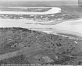
Kenai in the 1940s
-
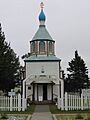
Holy Assumption Russian Orthodox Church
-
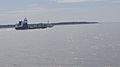
Fishing boats emerging from the Kenai River into Cook Inlet
See also
 In Spanish: Kenai (Alaska) para niños
