Cook Inlet facts for kids
Quick facts for kids Cook Inlet |
|
|---|---|
| Tikahtnu, Cungaaciq | |
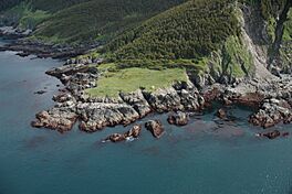
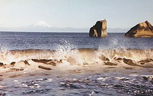
The navigational light at the southwestern tip of Elizabeth Island demarcates the boundary between Cook Inlet and the Gulf of Alaska
|
|
 |
|
| Location | South-central Alaska |
| Coordinates | 60°20′16″N 151°52′30″W / 60.33778°N 151.87500°W |
| Native name |
|
| River sources | Knik River, Little Susitna River, Susitna River, Matanuska River |
| Max. length | 180 miles (290 km) |
| Surface area | 100,000 km2 (39,000 sq mi) |
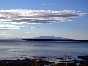
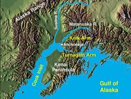
Cook Inlet is a large body of water in south-central Alaska. It stretches about 180 miles (290 km) from the Gulf of Alaska all the way to Anchorage. The local Dena'ina people call it Tikahtnu, and the Sugpiaq people call it Cungaaciq.
At its northern end, Cook Inlet splits into two long, narrow branches called the Knik Arm and Turnagain Arm. These arms almost surround the city of Anchorage. To the south, the inlet connects with other waterways like Shelikof Strait.
The water in Cook Inlet is a mix of ocean saltwater and fresh water from rivers and streams. This makes it brackish (a bit salty, a bit fresh) and often turbid (cloudy with sediment). The narrow shape of the inlet causes tides to move very fast. This creates strong currents, dangerous rip tides, and sometimes even bore tides, which are like walls of water.
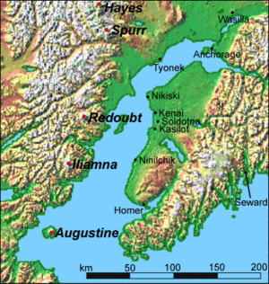
The land area that drains into Cook Inlet is called its watershed. It's the most populated watershed in Alaska, covering about 38,600 square miles (100,000 km²). Many rivers flow into the inlet, bringing water from glaciers and mountains, including Denali, North America's highest peak. This is why the water is so cloudy with silt. Several national parks and active volcanoes, like Mount Redoubt, are found in this watershed. Cook Inlet is important for shipping, providing access to the busy port of Anchorage and the smaller port of Homer. About 400,000 people live in the Cook Inlet watershed.
Contents
Exploring Cook Inlet's Landscape
Cook Inlet and the nearby Kenai Peninsula, Kenai Mountains, Chugach Mountains, and Kodiak Island formed about 65 million years ago. This was just after the time of the dinosaurs! Most of Alaska's mountains are made of rocks that were once at the bottom of the ocean.
This area is where the Pacific Plate (a huge piece of Earth's crust) slides under the North American Plate. This movement pushed up the ocean floor and squeezed the land, making the crust thicker and wrinkly. This process lifted the mountains and peninsula out of the water, creating a valley that became Cook Inlet. The mountains around Cook Inlet are quite young compared to other mountain ranges in Alaska.
Cook Inlet is in an area where the ground often sinks a bit, and there are many faults (cracks in the Earth's crust). This means earthquakes happen often here. The main fault is in the nearby Aleutian Trench in the Gulf of Alaska.
In 1964, a huge earthquake, one of the largest ever recorded (magnitude 9.2), hit this region. It caused parts of the Kenai Mountains to rise 60 feet (20 meters) in just minutes! But in other areas, like around Turnagain Arm, the ground sank 8 feet (2.4 meters). This caused towns like Portage and Girdwood to be flooded by the sea.
Because it's along a "subduction zone" (where one plate slides under another), the Cook Inlet area has active volcanoes. These include Augustine Volcano and Mount Redoubt. They are part of the Pacific Ring of Fire, a chain of volcanoes around the Pacific Ocean. Hot magma and steam build up in these volcanoes, causing powerful eruptions that can send ash thousands of feet into the sky. These eruptions can also cause earthquakes and tsunamis (giant ocean waves).
Understanding Cook Inlet's Tides
Cook Inlet has the fourth largest tidal range in the world. This means the difference between high tide and low tide is huge! The shape of the inlet and how it lines up with the moon's orbit makes the tide come in and go out very quickly. As the inlet gets narrower, the water speeds up, creating very strong currents that can reach 7 miles per hour (11 km/h).
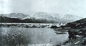
The strong tides create powerful rip tides and bore tides. Tidal bores happen almost daily in Turnagain Arm. A large bore looks like a wall of water, sometimes over 10 feet (3 meters) high, rushing in as the tide changes. These big bores usually happen during a new or full moon.
Unlike some parts of Alaska, the waters of Cook Inlet stay fairly warm. This is because of the Alaska Current from the Gulf of Alaska, which is part of a large ocean current system. This helps keep the weather in the Cook Inlet region milder than in other parts of the state.
A Look Back at Cook Inlet's Past
People have lived around Cook Inlet for a very long time. The first explorers and settlers were the Alutiiq people, who arrived about 6,000 years ago. Later, the Dena'ina people, who were Athabaskan tribes from inland Alaska, settled in the area.
In the 1700s, Russian fur hunters were among the first Europeans to visit. They set up trading posts to hunt for sea otters and other marine animals.
In 1778, the famous explorer James Cook sailed into the inlet while searching for the Northwest Passage. He was looking for a sea route that would connect the Atlantic and Pacific oceans through North America. Cook named the inlet after himself in 1794. He also named Turnagain Arm because he had to "turn again" after realizing it was a dead end, not the Northwest Passage. He was a bit annoyed!
Cook had initially planned to skip the inlet, but his crew convinced him to explore it. He anchored at Ship Creek and met local Native people. One of his officers, William Bligh (who later became famous for the mutiny on the Bounty), explored Knik Arm and confirmed it was just rivers, not a passage. Cook himself tried to sail up Turnagain Arm but got stuck on a sandbar because of the strong currents and mudflats. He never fully confirmed it was a river, which led to many years of guessing until another explorer, George Vancouver, mapped it properly.
In 1910, a wooden steamship called the SS Farallon hit a reef in Cook Inlet. All 38 men on board survived and were rescued almost a month later! Few non-Native people lived in upper Cook Inlet until the Alaska Railroad was built around 1915. The Native people of the Eklutna village are descendants of the original residents of eight Native villages around the upper inlet.
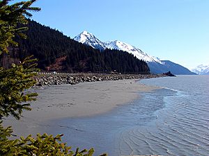
As mentioned before, the 1964 Alaska earthquake caused parts of the Seward Highway to sink below the water level. The highway and its bridges had to be rebuilt.
Communities Along the Inlet
Most of Alaska's population lives in the Cook Inlet area, especially in Anchorage. On the east side of the inlet, the Kenai Peninsula has many smaller fishing towns like Kenai, Soldotna, Ninilchik, Anchor Point, and Homer. Many people in these towns make their living from fishing in Cook Inlet.
The west side of the inlet is harder to reach, usually by boat or plane. It has the village of Tyonek, Alaska, some oil camps, and seasonal fishing camps.
Resources and Energy
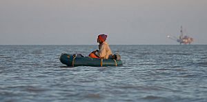
The Cook Inlet Basin has large amounts of oil and natural gas. As of 2005, there were 16 oil platforms in the inlet. The oldest was installed in 1964, and the newest in 2000. Many pipelines run around and under the inlet, carrying gas to places like Kenai (where it's used for fertilizer and liquid natural gas) and Anchorage (for homes).
Alaska also has a lot of coal. There's been a plan for decades to build a large coal mine, called the Chuitna Coal Project, on the west side of Cook Inlet near the Chuitna River. This project has raised concerns about its impact on the environment.
Turnagain Arm is one of only about 60 places in the world that has a tidal bore. This bore can be more than 6 feet (1.8 meters) high and travel at 15 miles per hour (24 km/h) during high tides. Turnagain Arm has the largest tidal range in the United States, with an average difference of 30 feet (9 meters) between high and low tide. It's the fourth highest in the world! The strong tides in the inlet and its arms have led to ideas about using them to generate tidal power (electricity from tides).
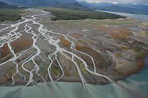
Both Turnagain Arm and Knik Arm are known for their huge areas of silt and mudflats. At low tide, much of this mud is exposed, making it hard for ships to navigate. Boats designed for this area often have flat bottoms so they can sit on the mud without damage if they get stuck at low tide.
These mudflats can be very dangerous to walk on because they act like quicksand. Several people, often tourists, have gotten stuck and even lost their lives. Many more are rescued each year.
Large cruise ships usually dock in Seward or Whittier and transport passengers to Anchorage by bus or train. However, over 95% of all goods entering Alaska come through the Port of Anchorage, which is a very busy port for large container ships.
Protecting Cook Inlet's Wildlife
The Cook Inlet beluga whale is a special group of whales found only here. Their population has dropped a lot, and they are now listed as critically endangered. This means they are at a very high risk of disappearing forever. Scientists are studying why their numbers have fallen. Killer whales sometimes hunt belugas in Cook Inlet, pushing them into shallower waters where they try to hide.
In 2008, the Cook Inlet beluga whale was added to the endangered species list. Many activities happen in Cook Inlet, like fishing, oil and gas work, shipping, and tourism. Scientists are trying to understand how these activities might affect the beluga whale population.
The Coastal Marine Institute at the University of Alaska Fairbanks is studying how water moves in Cook Inlet. Also, a group called Cook Inletkeeper was started in 1994 by Alaskans worried about changes in the inlet. Their goal is to "protect Alaska's Cook Inlet watershed and the life it sustains," focusing on clean water, healthy habitats, and local economies.
|
See also
 In Spanish: Ensenada de Cook para niños
 | Emma Amos |
 | Edward Mitchell Bannister |
 | Larry D. Alexander |
 | Ernie Barnes |


