Aleutian Trench facts for kids
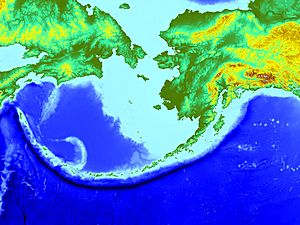
The Aleutian Trench is a very deep and long ditch in the ocean. It runs along the southern coast of Alaska and the Aleutian Islands. This trench is about 3,400 kilometers (2,100 miles) long. It stretches from a meeting point with other faults in the west to another fault system in the east.
The Aleutian Trench is a "convergent plate boundary." This means two huge pieces of the Earth's crust, called tectonic plates, are moving towards each other. Here, the Pacific Plate is sliding underneath the North American Plate. This process is called subduction.
As the Pacific Plate slides down, it creates the Aleutian Arc. This is a chain of volcanoes that form island arcs. The plates are moving closer together at a speed of about 7.5 centimeters (3 inches) each year.
Contents
How Deep is the Aleutian Trench?
The Aleutian Trench has sloping sides. The north side slopes at 3 to 4 degrees, and the south side slopes at 1 to 4 degrees.
The deepest part of the trench is about 7,822 meters (25,663 feet) deep. This is located southwest of Buldir Island. Imagine stacking almost 26 Empire State Buildings on top of each other to reach that depth!
Earthquakes and Tsunamis
The sliding of the Pacific Plate under the North American Plate causes many earthquakes along the Aleutian Trench. Some of these earthquakes have been very powerful and have caused huge tsunamis.
Here are some important earthquakes that happened near the Aleutian Trench:
1946 Aleutian Islands Earthquake
- This earthquake happened on April 1, 1946.
- It had a magnitude of 8.6.
- The earthquake caused a large tsunami.
- The tsunami destroyed a lighthouse and caused damage in Hawaii. It sadly killed 159 people in Hilo, Hawaii.
1957 Andreanof Islands Earthquake
- This earthquake occurred on March 9, 1957.
- It also had a magnitude of 8.6.
- The earthquake caused damage on Adak Island and Umnak Island.
- A tsunami from this quake traveled across the Pacific Ocean. It even reached as far as Chile.
1964 Alaska Earthquake
- This was a very powerful earthquake on March 27, 1964.
- It lasted for almost five minutes and had a magnitude of 9.2.
- It is the strongest earthquake ever recorded in North America.
- A huge section of the Earth's crust, about 970 kilometers (600 miles) long, moved up to 18 meters (60 feet).
- Most of the damage was in Anchorage, Alaska.
- A tsunami from this earthquake caused destruction as far away as California.
- In total, 131 people died from the earthquake and tsunami.
1965 Rat Islands Earthquake
- This earthquake happened on February 4, 1965.
- It had a magnitude of 8.7.
- It caused a tsunami that hit Shemya Island and was seen across the Pacific. However, it caused little damage.
Other Notable Earthquakes
- May 7, 1986: A magnitude 7.9 earthquake near the Andreanof Islands. It caused damage on Adak Island and Atka Island.
- June 23, 2014: A magnitude 7.9 earthquake near Little Sitkin Island, Alaska.
- July 17, 2017: A magnitude 7.7 earthquake southeast of Nikol'skoye, Russia.
- January 23, 2018: A magnitude 7.9 earthquake southeast of Kodiak, Alaska.
See also
 In Spanish: Fosa de las Aleutianas para niños
 | George Robert Carruthers |
 | Patricia Bath |
 | Jan Ernst Matzeliger |
 | Alexander Miles |


