
Mount Redoubt facts for kids
Quick facts for kids Mount Redoubt |
|
|---|---|

Steaming at the active summit lava dome on May 8, 2009
|
|
| Highest point | |
| Elevation | 10,197 ft (3,108 m) |
| Prominence | 9,150 ft (2,790 m) |
| Listing |
|
| Naming | |
| Native name | Error {{native name}}: an IETF language tag as parameter {{{1}}} is required (help) |
| Geography | |

Mount Redoubt
Location in Alaska
|
|
| Location | Lake Clark National Park and Preserve, Kenai Peninsula Borough, Alaska, United States |
| Parent range | Chigmit Mountains, Aleutian Range |
| Geology | |
| Age of rock | 890,000 years |
| Mountain type | Stratovolcano |
| Volcanic arc/belt | Aleutian Arc |
| Last eruption | March to July 2009 |
| Climbing | |
| First ascent | 1959 by C Deehr, J Gardey, F Kennell, G Wescott |
| Easiest route | snow/ice climb |
| Designated: | 1976 |

Mount Redoubt, also known as Redoubt Volcano, is an active volcano in Alaska. Its native name in the Dena'ina is Bentuggezh K’enulgheli. This volcano is part of the Aleutian Range.
It is located in Lake Clark National Park and Preserve, near Cook Inlet. The mountain is about 110 miles (177 km) southwest of Anchorage. Mount Redoubt stands 10,197 feet (3,108 meters) tall. It is the highest peak in the Aleutian Range. In 1976, it was named a National Natural Landmark.
Mount Redoubt has erupted several times. Major eruptions happened in 1902, 1966, 1989, and 2009. The 1989 eruption sent volcanic ash 45,000 feet (13,700 meters) into the sky. A Boeing 747 plane, KLM Flight 867, flew into this ash cloud. All four of its engines stopped working! Luckily, the pilots were able to restart the engines. They landed the plane safely in Anchorage. This eruption also covered about 7,700 square miles (20,000 km²) with ash. Scientists were able to predict the 1989 eruption. This was the first time a volcano eruption was successfully predicted using a new method.
Contents
What's in a Name?
The official name, Redoubt Volcano, comes from the Russian name "Sopka Redutskaya". The word "redoubt" means "a fortified place." A local name, "Ujakushatsch," also means "fortified place." The Board on Geographic Names officially chose "Redoubt Volcano" in 1891.
The Smithsonian Institution calls the mountain simply "Redoubt." It also lists other names like Burnt Mountain and Goreloi. The Alaska Volcano Observatory also uses "Redoubt" and lists similar alternate names.
How Was Mount Redoubt Formed?

Mount Redoubt is about 3.7 miles (6 km) wide at its base. It is made of pyroclastic flow deposits and lava flows. These are layers of rock and hardened lava. The mountain sits on older rocks from the Mesozoic era.
Several glaciers on the mountain have shaped its sides. The main opening where lava and ash come out is on the north side. This vent is near the Drift glacier. Mudflows, called lahars, have also flowed from the mountain. These mudflows have reached as far as the Cook Inlet. The volcano has produced different types of rock, including andesite, basalt, and dacite.
History of Eruptions

People have seen activity at Mount Redoubt for a long time. Captain James Cook saw it in 1778. He described it as "emitting a white smoke." However, many sources say this was not a true eruption. In 1819, smoke was also seen, but there wasn't enough information to call it an eruption.
In 2003, a cloud of snow blowing from the mountain was mistaken for an ash plume. This shows how hard it can be to tell the difference!
The 1881 Eruption
There was an eruption in 1881. It was described as "constantly smoking, with periods of exaggerated activity." Some reports even said "fire has been seen issuing from its summit." A story tells of native hunters being caught in a lava flow during this eruption. However, this event is not well documented by other sources.
The 1902 Eruption
The volcano erupted suddenly in 1902. It spewed ash from January 18 to June 21. A local newspaper reported that the area for 150 miles (240 km) around was "covered with ashes and lava." Another report said it was a "terrific earthquake which burst the mountain asunder." This might mean a crack formed in the crater. The eruption was said to have terrified local people. Ash reportedly traveled across the Cook Inlet.
The 1989–1990 Eruption

Mount Redoubt erupted on December 14, 1989. The eruption continued for over six months. Hot pyroclastic flows and collapsing lava domes melted snow and ice at the summit. This caused large mudflows, or lahars. These mudflows rushed down the north side of the mountain. Most of them reached Cook Inlet, about 22 miles (35 km) away. The lahars entered a nearby river. This worried officials because an oil storage facility was located along the river.
Scientists used these mudflows to test a new device. This device, called an Acoustic Flow Monitor, helps detect lahars. It warns nearby stations about possible mudflows.
As mentioned, this eruption also caused a KLM airliner to lose power in all four engines. The plane flew into a cloud of volcanic ash. The damage from this eruption was estimated at $160 million. This made it the second most expensive volcanic eruption in United States history.
The 2009 Eruption
Before the Eruption

On January 24, 2009, a magnitude 5.8 earthquake hit the area. Its connection to the eruption is not known. On January 30, 2009, scientists from the Alaska Volcano Observatory (AVO) warned that an eruption was coming. People in south-central Alaska began preparing for volcanic ash.
By January 31, volcanic earthquakes increased. A large hole was seen in the glacier on the mountain's side. Scientists watched the mountain's seismic data 24 hours a day. This helped them warn nearby communities. A flight by the AVO saw "significant steaming from a new melt depression" near the crater.
March 15 Activity

On March 15, 2009, seismic activity at Redoubt increased. An AVO flight reported a steam and ash plume. It rose as high as 15,000 feet (4,570 meters) above sea level. This caused a small amount of ash to fall on the mountain's upper south side. The AVO then raised the alert level for the volcano.
What Came Out?
The volcano mainly released water vapor. It also released smaller amounts of carbon dioxide and sulfur dioxide. Studies showed that the materials were not very oxidized. They contained less than 20% sulfates.
Major Eruptions Begin

Mount Redoubt erupted explosively on the evening of March 22, 2009. The AVO recorded many volcanic eruptions and explosions during this time.
See also
 In Spanish: Monte Redoubt para niños
Images for kids
-
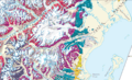
Geologic map of Redoubt Volcano.

