
Homer, Alaska facts for kids
|
|||||||||||||||||||||||||||||||||||||||||||||||||||


Homer (in the Dena'ina language: Tuggeght) is a city in Kenai Peninsula Borough in the state of Alaska. It is about 218 miles (351 km) southwest of Anchorage. In 2020, about 5,522 people lived there.
Homer is famous as the "Halibut Fishing Capital of the World." People also call it "the end of the road" because it's the last town on the main highway system in Alaska. More recently, it's been called "the cosmic hamlet by the sea."
Contents
Exploring Homer's Location

Homer is located at 59°38'35" North and 151°31'33" West. The only road that leads into Homer is the Sterling Highway. The town covers about 25.5 square miles (66 square km). Most of this area is land, but about 10.5 square miles (27 square km) are covered by water.
Homer sits on the edge of Kachemak Bay, which is on the southwest side of the Kenai Peninsula. A special feature of Homer is the Homer Spit. This is a narrow, gravel bar that stretches about 4.5 miles (7.2 km) into the bay. The Homer Harbor is located on this spit.
During the big Good Friday earthquake in March 1964, much of the coastline and the Homer Spit sank. After the earthquake, very few plants could grow on the Homer Spit for a while.
What is Homer's Climate Like?
Homer has a mild subarctic climate. This means its weather is not as extreme as other parts of Alaska. Winters are long and snowy, but they are not super cold for this part of the world. The average high temperature in January is just below freezing.
Homer gets about 50 inches (127 cm) of snow each year. Most of this snow falls from November to March. It rarely snows in May. The city also gets about 25 inches (64 cm) of rain each year. This is because the Chugach Mountains protect it from heavy rain coming from the Gulf of Alaska.
| Climate data for Homer, Alaska (Homer Airport), 1991–2020 normals, extremes 1932–present | |||||||||||||
|---|---|---|---|---|---|---|---|---|---|---|---|---|---|
| Month | Jan | Feb | Mar | Apr | May | Jun | Jul | Aug | Sep | Oct | Nov | Dec | Year |
| Record high °F (°C) | 57 (14) |
53 (12) |
54 (12) |
65 (18) |
72 (22) |
80 (27) |
81 (27) |
78 (26) |
69 (21) |
64 (18) |
58 (14) |
52 (11) |
81 (27) |
| Mean maximum °F (°C) | 44.7 (7.1) |
44.6 (7.0) |
45.8 (7.7) |
54.4 (12.4) |
63.8 (17.7) |
68.2 (20.1) |
70.3 (21.3) |
70.2 (21.2) |
63.3 (17.4) |
55.9 (13.3) |
47.9 (8.8) |
45.5 (7.5) |
72.9 (22.7) |
| Mean daily maximum °F (°C) | 31.8 (−0.1) |
34.9 (1.6) |
37.1 (2.8) |
46.1 (7.8) |
53.8 (12.1) |
59.3 (15.2) |
63.1 (17.3) |
62.6 (17.0) |
56.7 (13.7) |
47.1 (8.4) |
37.6 (3.1) |
34.0 (1.1) |
47.0 (8.3) |
| Daily mean °F (°C) | 25.4 (−3.7) |
28.3 (−2.1) |
30.1 (−1.1) |
38.7 (3.7) |
46.0 (7.8) |
52.0 (11.1) |
56.1 (13.4) |
55.3 (12.9) |
49.5 (9.7) |
40.2 (4.6) |
31.2 (−0.4) |
27.7 (−2.4) |
40.0 (4.4) |
| Mean daily minimum °F (°C) | 19.0 (−7.2) |
21.7 (−5.7) |
23.1 (−4.9) |
31.3 (−0.4) |
38.2 (3.4) |
44.7 (7.1) |
49.2 (9.6) |
48.0 (8.9) |
42.3 (5.7) |
33.3 (0.7) |
24.8 (−4.0) |
21.4 (−5.9) |
33.1 (0.6) |
| Mean minimum °F (°C) | −0.6 (−18.1) |
4.3 (−15.4) |
7.0 (−13.9) |
19.9 (−6.7) |
29.4 (−1.4) |
36.7 (2.6) |
41.4 (5.2) |
38.7 (3.7) |
30.2 (−1.0) |
20.2 (−6.6) |
9.0 (−12.8) |
3.7 (−15.7) |
−4.4 (−20.2) |
| Record low °F (°C) | −24 (−31) |
−19 (−28) |
−21 (−29) |
−9 (−23) |
6 (−14) |
27 (−3) |
34 (1) |
31 (−1) |
20 (−7) |
0 (−18) |
−7 (−22) |
−16 (−27) |
−24 (−31) |
| Average precipitation inches (mm) | 2.15 (55) |
1.82 (46) |
1.32 (34) |
1.15 (29) |
0.78 (20) |
0.87 (22) |
1.45 (37) |
2.31 (59) |
3.28 (83) |
2.61 (66) |
2.87 (73) |
3.27 (83) |
23.88 (607) |
| Average snowfall inches (cm) | 9.1 (23) |
9.6 (24) |
7.0 (18) |
1.9 (4.8) |
trace | 0.0 (0.0) |
0.0 (0.0) |
0.0 (0.0) |
0.0 (0.0) |
2.6 (6.6) |
7.0 (18) |
10.2 (26) |
47.4 (120.4) |
| Average precipitation days (≥ 0.01 in) | 14.1 | 12.4 | 10.7 | 10.2 | 9.7 | 9.8 | 12.1 | 14.3 | 16.5 | 14.9 | 14.7 | 16.9 | 156.3 |
| Average snowy days (≥ 0.1 in) | 8.0 | 6.4 | 5.2 | 1.9 | 0.1 | 0.0 | 0.0 | 0.0 | 0.0 | 2.2 | 5.4 | 7.6 | 36.8 |
| Average relative humidity (%) | 79.7 | 78.0 | 74.0 | 73.8 | 74.2 | 76.2 | 80.2 | 81.6 | 81.4 | 78.5 | 78.9 | 79.4 | 78.0 |
| Average dew point °F (°C) | 17.4 (−8.1) |
18.7 (−7.4) |
21.6 (−5.8) |
27.7 (−2.4) |
35.4 (1.9) |
42.3 (5.7) |
47.8 (8.8) |
47.8 (8.8) |
42.3 (5.7) |
31.3 (−0.4) |
23.0 (−5.0) |
19.0 (−7.2) |
31.2 (−0.4) |
| Mean monthly sunshine hours | 93 | 141.3 | 186 | 240 | 279 | 270 | 248 | 186 | 150 | 124 | 90 | 62 | 2,069.3 |
| Mean daily sunshine hours | 3 | 5 | 6 | 8 | 9 | 9 | 8 | 6 | 5 | 4 | 3 | 2 | 6 |
| Percent possible sunshine | 43 | 54 | 50 | 55 | 52 | 48 | 45 | 39 | 39 | 40 | 39 | 33 | 45 |
| Average ultraviolet index | 0 | 0 | 1 | 3 | 4 | 5 | 5 | 4 | 2 | 1 | 0 | 0 | 2 |
| Source 1: NOAA (relative humidity and dew point 1961–1990)(average snowfall/snow days 1981–2010) | |||||||||||||
| Source 2: Weather Atlas (sun and uv) | |||||||||||||
| Coastal temperature data for Homer | |||||||||||||
|---|---|---|---|---|---|---|---|---|---|---|---|---|---|
| Month | Jan | Feb | Mar | Apr | May | Jun | Jul | Aug | Sep | Oct | Nov | Dec | Year |
| Average sea temperature °F (°C) | 37.6 (3.11) |
38.3 (3.50) |
37.2 (2.89) |
38.8 (3.78) |
42.1 (5.61) |
46.8 (8.22) |
50.4 (10.22) |
52.0 (11.11) |
51.6 (10.88) |
47.7 (8.72) |
43.5 (6.39) |
41.0 (5.00) |
43.9 (6.65) |
| Source 1: Seatemperature.net | |||||||||||||
- Notes
Homer's History
.jpg)


Long ago, early Alutiiq people likely camped in the Homer area. Their main villages were on the other side of Kachemak Bay.
How Did Homer Get Its Name?
In the 1890s, people found coal in the area. A company called Cook Inlet Coal Fields built a town, a dock, a coal mine, and a railroad in Homer. Coal mining continued here until World War II. Experts believe there are still about 400 million tons of coal in the area.
Homer was named after Homer Pennock. He was a promoter for a gold mining company. In 1896, he arrived on the Homer Spit and built homes for his 50 workers. However, gold mining never made much money in this area.
Another early settlement was Miller's Landing. It was named after Charles Miller, who settled there around 1915. He worked for the Alaska Railroad and kept company horses on the Homer Spit during winter. He built a small landing spot where supply boats from Seldovia could unload goods. Miller's Landing was considered a separate place until 2002, but locals always saw it as part of Homer.
Today, Homer's main industries are halibut and salmon sport fishing, tourism, and commercial fishing. Homer also helped host the 2006 Arctic Winter Games. You can visit the Alaska Maritime National Wildlife Refuge and the Kachemak Bay Research Reserve at the Alaska Islands and Ocean Visitor Center. The Pratt Museum is also a great place to learn about the area's culture and history.
Who Lives in Homer?
| Historical population | |||
|---|---|---|---|
| Census | Pop. | %± | |
| 1940 | 325 | — | |
| 1950 | 307 | −5.5% | |
| 1960 | 1,247 | 306.2% | |
| 1970 | 1,083 | −13.2% | |
| 1980 | 2,209 | 104.0% | |
| 1990 | 3,660 | 65.7% | |
| 2000 | 3,946 | 7.8% | |
| 2010 | 5,003 | 26.8% | |
| 2020 | 5,522 | 10.4% | |
| 2022 (est.) | 5,876 | 17.4% | |
| U.S. Decennial Census | |||
Homer first appeared in the U.S. Census in 1940. It officially became a city in 1964.
In 2010, there were 5,003 people living in Homer. There were 2,235 households, and 1,296 families. The population density was about 361.7 people per square mile. Most residents (89.3%) were White. About 4.1% were American Indian or Alaska Native.
The average age of people in Homer was 44 years old. About 21.9% of residents were under 18. About 14.5% were 65 years or older. The city had slightly more females (50.5%) than males (49.5%). The average income for a household was $52,057.
Learning in Homer

Schools and Library
The Kenai Peninsula Borough School District provides education for students in Homer. The schools include:
- Homer High School (grades 9-12)
- Homer Flex High School (grades 9-12)
- Homer Middle School (grades 7-8)
- West Homer Elementary (grades 3-6)
- Paul Banks Elementary (grades K-2)
- McNeil Canyon Elementary (grades K-6)
- Fireweed Academy (grades K-6)
- Connections Homeschool Program (grades K-12)
The Kachemak Bay Campus is part of Kenai Peninsula College. It offers college-level courses, ESL (English as a Second Language) classes, and GED training.
The Homer Public Library is very popular. The Friends of the Homer Library group, started in 1948, helped raise money for a new building. The new library opened on September 16, 2006.
Science Education and Nature
Homer is a great place for learning about nature. It has many natural resources and ocean habitats. There are several public education programs focused on the environment.
These include the Alaska Maritime National Wildlife Refuge Visitor Center, also known as the Alaska Island and Ocean Center. Another is the Center for Alaskan Coastal Studies. Both groups promote science education. They host events to teach people of all ages about the local ecosystem and how to protect it. Some events are the Kachemak Crane Watch and the Kachemak Bay Science Conference.
Kachemak Bay Shorebird Festival

Homer hosts the Kachemak Bay Shorebird Festival every year. It started in 1993 to teach people about shorebirds and their wetland homes. Now, the Alaska Maritime National Wildlife Refuge and the Friends of Alaska National Wildlife Refuges sponsor the festival.
The festival happens in early May. This is when over 13,000 shorebirds from 25 different species visit Kachemak Bay during their spring migration. Tourists and Alaskans come to watch the birds. They can take land and boat tours.
Some birds you might see include horned puffins, sandhill cranes, and arctic terns. Arctic Terns are famous for flying the longest distance of any migrating bird. The festival also has a "Shorebirds Sing: Bird Call Contest." Here, people try to copy the sounds of different bird species.
In 2020, the festival was held online because of the COVID-19 pandemic. In 2021, it was a mix of online and in-person events.
Media in Homer

Homer has one newspaper called the Homer News. It comes out once a week. It started in 1964.
There are also several radio stations in Homer:
- KWVV-FM at 103.5 FM (commercial)
- KGTL at 620 AM (commercial)
- Public radio KBBI at 890 AM
Homer also gets seven analog television stations. These stations are rebroadcast into Homer using special equipment called repeaters.
- KTUU-TV Channel 2 - NBC
- KTBY Channel 4 - Fox
- KAKM Channel 7 - PBS
- KAUU Channel 9 - MyNetworkTV
- KTVA Channel 11 - CBS
- KYUR Channel 13 - ABC
Getting Around Homer

Homer is the southernmost town connected to Alaska's main highway system. It is also part of the Alaska Marine Highway, which is Alaska's ferry system. The Homer Airport is near the coast. You can take local air taxis or scheduled flights to Anchorage from there. In 2005, Homer got its first traffic light.
The United States Coast Guard has a ship stationed in Homer. From 1992 to 2015, the ship was the Roanoke Island. It was replaced by the Sapelo. The Sapelo is expected to be replaced by a newer ship soon.
Famous People from Homer

Many interesting people have connections to Homer:
- Tom Bodett (born 1955) is a writer and spokesperson. He is known for the Motel 6 ads that say, "We'll leave the light on for you." He also wrote a fun book about Homer called As Far as You Can go Without a Passport.
- Lincoln Brewster (born 1971) is a Christian music artist.
- Kristen Faulkner (born 1992) is a professional cyclist. She won two gold medals at the 2024 Paris Olympics.
- Hazel P. Heath (1909–1998) was a businesswoman and served as the mayor of Homer from 1968 to 1976.
- Jewel (Jewel Kilcher) (born 1974) is a famous singer and songwriter.
- Jean Keene (1923–2009) was known as the "Eagle Lady" of Homer. She spent decades feeding bald eagles on the Homer Spit.
- Andre Marrou (born 1938) lived in Homer when he was elected to the Alaska House of Representatives in 1984 as a Libertarian member.
- Shannyn Moore (born 1970) is a political writer from Alaska.
- Tela O'Donnell (born 1982) is an Olympic wrestler.
- Ambrose Olsen (1985–2010) was a male fashion model.
- Dana Stabenow (born 1952) is an American author.
Images for kids
-
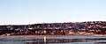
Downtown Homer seen from Beluga Slough
-
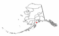
Location of Homer, Alaska
-
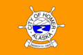
Flag of Homer, Alaska
See also
 In Spanish: Homer (Alaska) para niños
