Shelikof Strait facts for kids
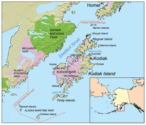
The Shelikof Strait (pronounced SHEL-i-kof) is a narrow stretch of water in Alaska, a state in the United States. It is located on the southwestern coast of Alaska. This strait separates the main part of Alaska from two islands: Kodiak and Afognak islands.
Contents
About Shelikof Strait
The Shelikof Strait is like a long, watery highway. It separates the mainland coast of the Kodiak Island Borough from the part of the borough that is on Kodiak Island itself.
Location and Size
This strait is about 150 miles (240 kilometers) long. It is also quite wide, ranging from 25 to 30 miles (40 to 48 kilometers) across. At its northern end, you'll find Cook Inlet, another important body of water.
Strong Tides
The Shelikof Strait is famous for its very strong tides. Tides are the rise and fall of sea levels, caused by the gravity of the Moon and Sun. Because the strait is so close to Cook Inlet, which has some of the biggest tides in the world, the water levels in Shelikof Strait can change a lot. The difference between high tide and low tide can be as much as 40 feet (12 meters)! This means the water can go up and down by the height of a four-story building.
Who was Shelikof?
The strait is named after a man named Grigory Shelikhov. He was a Russian fur trader who lived from 1747 to 1795. His name is sometimes spelled "Shelikof." Grigory Shelikhov was important because he started the very first Russian settlement in what is now Alaska. He built this settlement in 1784 at a place called Three Saints Bay on Kodiak Island.
USS Shelikof
A ship in the United States Navy was also named after the Shelikof Strait. This ship was called the USS Shelikof (AVP-52). It was a special type of ship called a seaplane tender, which means it helped support seaplanes. The USS Shelikof was used by the Navy from 1944 to 1947 and again from 1952 to 1954.
See also
 In Spanish: Estrecho de Shelikof para niños
 | Jackie Robinson |
 | Jack Johnson |
 | Althea Gibson |
 | Arthur Ashe |
 | Muhammad Ali |


