Kodiak Island Borough, Alaska facts for kids
Quick facts for kids
Kodiak Island Borough
|
||
|---|---|---|
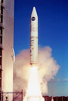
Athena 1 rocket launching from Kodiak Island.
|
||
|
||
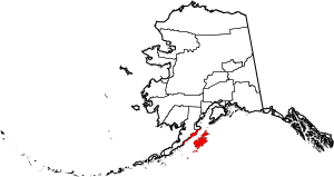
Location within the U.S. state of Alaska
|
||
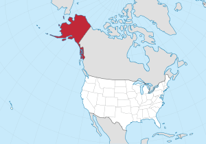 Alaska's location within the U.S. |
||
| Country | ||
| State | ||
| Incorporated | September 24, 1963 | |
| Named for | Kodiak Island | |
| Seat | Kodiak | |
| Largest city | Kodiak | |
| Area | ||
| • Total | 12,022 sq mi (31,140 km2) | |
| • Land | 6,550 sq mi (17,000 km2) | |
| • Water | 5,472 sq mi (14,170 km2) 45.5%% | |
| Population
(2020)
|
||
| • Total | 13,101 | |
| • Estimate
(2022)
|
12,720 |
|
| • Density | 1.08975/sq mi (0.42076/km2) | |
| Time zone | UTC−9 (Alaska) | |
| • Summer (DST) | UTC−8 (ADT) | |
| Congressional district | At-large | |
The Kodiak Island Borough is a special kind of county in the state of Alaska. It's a large area that includes Kodiak Island and many smaller islands nearby. The main town and government center, called the borough seat, is Kodiak.
In 2020, about 13,101 people lived here. The borough was officially created on September 24, 1963.
Contents
Exploring the Geography of Kodiak Island Borough
The Kodiak Island Borough is huge! It covers a total area of about 12,022 square miles. Imagine an area bigger than some small countries! A big part of this area is land, about 6,550 square miles. The rest, about 5,472 square miles, is water. This means almost half of the borough is covered by water.
Islands and Waterways
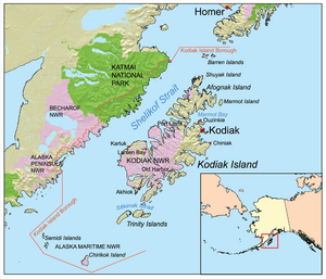
Most of the land in the borough is on Kodiak Island itself. But there are many other islands that are part of the borough too. These include:
- Afognak Island
- Shuyak Island
- Marmot Island
- Raspberry Island
- Little Raspberry Island
- Whale Island
- Spruce Island
- Woody Island
- Uganik Island
- Sitkalidak Island
- Tugidak Island
- Sitkinak Island
- Chirikof Island
- The Semidi Islands
There's also a narrow strip of land on the western side of the Alaska Peninsula that belongs to the borough. The water channel between Kodiak Island and the mainland is called the Shelikof Strait.
A Great Spot for Space Launches
South of Kodiak Island, you'll find the wide-open Pacific Ocean. This location is perfect for launching certain types of satellites into space! The Kodiak Launch Complex is here. It's great for sending satellites into special paths around Earth, like Molniya orbits and polar orbits.
Neighboring Areas
The Kodiak Island Borough shares borders with two other boroughs in Alaska:
- To the north, it's next to the Kenai Peninsula Borough, Alaska.
- To the northwest, it borders the Lake and Peninsula Borough, Alaska.
Protected Natural Areas
The Kodiak Island Borough is home to parts of several important protected natural areas. These places help keep Alaska's amazing wildlife and beautiful landscapes safe.
- Alaska Maritime National Wildlife Refuge: This refuge protects many islands and coastal areas. It includes the Barren Islands, the Semidi Wilderness (which covers the Semidi Islands), and the Trinity Islands (including Sitkinak Island and Tugidak Island).
- Alaska Peninsula National Wildlife Refuge: A part of this large refuge is also in the borough.
- Becharof National Wildlife Refuge: This refuge also has a section within the borough, including part of the Becharof Wilderness.
- Chugach National Forest: A small part of this vast forest is found here.
- Katmai National Park and Preserve: This famous park, known for its volcanoes and brown bears, has a section in the borough, including part of the Katmai Wilderness.
- Kodiak National Wildlife Refuge: This refuge is entirely within the borough and is famous for protecting the giant Kodiak bear.
Population Over Time
The number of people living in Kodiak Island Borough has changed over the years. Here's a quick look at how the population has grown and shrunk:
- In 1960, there were 7,174 people.
- By 1970, it grew to 9,409.
- In 1980, the population was 9,939.
- It jumped to 13,309 in 1990.
- In 2000, it reached 13,913.
- By 2010, it slightly decreased to 13,592.
- In 2020, the population was 13,101.
Towns and Villages
The Kodiak Island Borough has several towns and villages where people live.
Cities
These are larger communities with their own local governments:
- Akhiok
- Kodiak (This is the main town and the borough seat)
- Larsen Bay
- Old Harbor
- Ouzinkie
- Port Lions
Census-designated places
These are smaller communities that don't have their own city government but are recognized for collecting population data:
- Aleneva
- Chiniak
- Karluk
- Kodiak Station
- Mill Bay
- Womens Bay
See also
 In Spanish: Burgo de Isla Kodiak para niños
 | Toni Morrison |
 | Barack Obama |
 | Martin Luther King Jr. |
 | Ralph Bunche |


