Barren Islands facts for kids

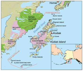
The Barren Islands are the northernmost islands in the Kodiak Archipelago, and are located northeast of Shuyak Island and southwest of the Kenai Peninsula.
|
|
| Geography | |
|---|---|
| Location | Gulf of Alaska |
| Coordinates | 58°55′N 152°16′W / 58.917°N 152.267°W |
| Archipelago | Kodiak Archipelago |
| Total islands | 6 |
| Area | 42.03 km2 (16.23 sq mi) |
| Administration | |
|
United States
|
|
| State | Alaska |
| Borough | Kodiak Island |
| Demographics | |
| Population | 0 (2010) |
| Additional information | |
| Part of Alaska Maritime National Wildlife Refuge | |
The Barren Islands are a group of islands in Alaska, a state in the United States. They are the most northern islands of the Kodiak Archipelago. The largest island in this group is Ushagat Island. These islands cover about 16 square miles (42 square kilometers) and no one lives on them.
The Barren Islands are very important for seabirds. They have the biggest seabird breeding areas in Alaska, especially on East Amatuli Island and Nord Island. The islands are also part of the Alaska Maritime National Wildlife Refuge, which helps protect wildlife.
Contents
Island Geography and Location
The Barren Islands are found in the Gulf of Alaska, off the south-central coast of Alaska. They are the northernmost part of the Kodiak Archipelago. These islands are located between the Kenai Peninsula to their northeast and Shuyak Island to their southwest. They stretch for about 15 miles (24 kilometers) across the Gulf of Alaska.
The Six Barren Islands
The Barren Islands group is made up of six main islands:
- East Amatuli Island: This is the island furthest to the east. It is about 2.5 miles (4 kilometers) long.
- West Amatuli Island (also called Amatuli Island): This island is about 3 miles (5 kilometers) long. It sits between East Amatuli and Ushagat Islands.
- Ushagat Island: This is the largest and westernmost island, about 8 miles (13 kilometers) long.
- Nord Island: This small island is about 0.5 miles (0.8 kilometers) wide. It is located northeast of Ushagat Island.
- Sud Island: This island is about 1 mile (1.6 kilometers) long. It is located northwest of Nord Island.
- Sugarloaf Island: This island is about 0.7 miles (1.1 kilometers) wide. It is located south of East and West Amatuli Islands.
Important Island Landmarks
There are a couple of notable places on the islands:
- Amatuli Cove: This is a cove about 0.6 miles (1 kilometer) wide on the northwest coast of East Amatuli Island.
- Table Mountain: This mountain is 1,350 feet (411 meters) tall. It is located on the northeast end of Ushagat Island.
Island Management and Protection
No people live on the Barren Islands. They are managed as part of Alaska's Kodiak Island Borough. The islands are also a key part of the Gulf of Alaska Unit within the Alaska Maritime National Wildlife Refuge. This refuge works to protect the natural environment and the many animals that live there, especially the seabirds.
History of the Barren Islands
The Barren Islands were given their name on May 25, 1778, by a famous British explorer named James Cook. He was a Captain in the Royal Navy. Captain Cook wrote that he named them "Barren Isles" because they looked very "naked," meaning they had little to no trees or plants.
 | Shirley Ann Jackson |
 | Garett Morgan |
 | J. Ernest Wilkins Jr. |
 | Elijah McCoy |

