
Susitna River facts for kids
Quick facts for kids Susitna River |
|
|---|---|

Susitna River in Southcentral Alaska
|
|

Location of the mouth of the Susitna River in Alaska
|
|
| Country | United States |
| Physical characteristics | |
| Main source | 2,500 ft (760 m) 63°26′10″N 147°11′55″W / 63.43611°N 147.19861°W Susitna Glacier on Mount Hayes |
| River mouth | 0 ft (0 m) 61°16′14″N 150°34′33″W / 61.27056°N 150.57583°WCook Inlet of Pacific Ocean, at Matanuska-Susitna Borough, Alaska |
| Length | 313 mi (504 km) |
| Basin features | |
| Basin size | 20,000 sq mi (52,000 km2) |
The Susitna River is a long river in Southcentral Alaska, United States. It flows for about 313 miles (504 km). This makes it one of the longest rivers in the state. It is also the 15th largest river in the U.S. based on how much water flows out of it. The river starts at the Susitna Glacier and ends in Cook Inlet.
What's in a Name? The Susitna River's History
The name Susitna comes from the Dena'ina people. In their language, Susitnu means "sandy river." This name was first written down by Russian explorers in 1847.
The river was likely first explored by outsiders in 1834. A person named Malakov, who was part Creole and part Indian, explored it then. The name "Susitna" has changed a bit over time to its current spelling.
Where Does the Susitna River Flow?
The Susitna River begins at the Susitna Glacier. This glacier is located in the Alaska Range mountains. From there, the river flows southwest. It eventually reaches Cook Inlet, which is an arm of the Pacific Ocean. Cook Inlet is about 24 miles (39 km) west of Anchorage, Alaska.
The Susitna River has many smaller rivers that flow into it. These are called tributaries. Some of the main ones are the East Fork Susitna River and the West Fork Susitna River. The Little Susitna River is a separate river system. It flows into Cook Inlet on its own.
The Susitna River, along with the Matanuska River, helps drain a large area. This area is known as the Matanuska-Susitna Valley. It is located south of the Alaska Range.
The river flows past several towns. These include Talkeetna and Susitna. It also receives water from the Yentna River. The Susitna River is deep enough for boats to travel on it. Boats can go about 85 miles (137 km) upstream to Talkeetna.
Fishing and Recreation on the Susitna River
The Susitna River is a great place for fishing. Many people come here to catch different types of salmon. These include Chinook and Coho salmon. Other fish like grayling, burbot, and rainbow trout also live here.
It's not easy to get to some parts of the river. Many areas are without roads. People often use power boats or floatplanes to reach these spots.
Some areas along the river are owned by the Matanuska-Susitna Borough. Sometimes, too many visitors can cause problems. For example, plants along the riverbanks can get damaged. The soil can also wear away, which is called erosion. Efforts have been made to fix some of these issues.
Important Locations and Features
The Susitna River is on the north side of Cook Inlet. Mount Susitna is a tall mountain nearby. It is about 6 miles (10 km) west of the river's mouth.
The river's channels near its mouth are shallow. They can change often, especially in winter and spring. This is due to ice and strong water flows.
Boats can travel up the Susitna River to the Yentna River. This is about 20 miles (32 km) from Cook Inlet. The tides from Cook Inlet do not affect the river much past 7 miles (11 km) upstream. Above that, the current is very strong.
There are a few small settlements along the river. Alexander is on the west side. Susitna, Alaska is on the east side. Mail is delivered to these places by airplane.
The Susitna Flats are a flat area of land. They are located between the Susitna River and the Little Susitna River. The Susitna Flats Light is a navigation aid in this area. It helps boats find their way.
Susitna River Bridges
The Susitna River Bridge is a famous railroad bridge. It is part of the Alaska Railroad. This bridge crosses the Susitna River near Gold Creek. It is listed on the National Register of Historic Places. This means it is an important historical site.
The bridge was built between October 1920 and February 1921. It is 503 feet (153 meters) long. The middle of the bridge is 71 feet (22 meters) high. It is made of 2,000 tons of steel. The bridge rests on two large concrete supports.
Ice on the Susitna River
The Susitna River freezes over every winter. This usually happens between October 19 and November 14. The ice then breaks up in the spring. This usually occurs between April 12 and May 10.
Rivers that Join the Susitna
Many rivers and streams flow into the Susitna River. These are its main tributaries:
- East Fork Susitna River
- West Fork Susitna River
- Yentna River
- Deshka River
- Talkeetna River
- Chulitna River
- Oshetna River
- Tyone River
- Maclaren River
Images for kids
-
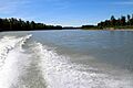
Susitna River on a clear sunny day in June 2015 near Talkeetna.
-
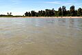
Susitna River on a clear sunny day in June 2015 near Talkeetna.
-
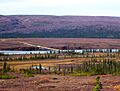
The Denali Highway crosses the upper Susitna river
-
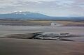
Susitna River delta with Mount Susitna on the left skyline.


See also
 In Spanish: Río Susitna para niños
