
Matanuska River facts for kids
Quick facts for kids Matanuska River |
|
|---|---|

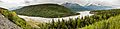
Silt-laden waters of the Chickaloon River (right center) enter the Matanuska River at mile 76 (km 123) of the Glenn Highway (upper right), a major highway connecting Anchorage to the rest of the state. The valley is forested with black cottonwood, balsam poplar, white spruce and paper birch.
|
|

South-central Alaska, near Anchorage
|
|

Location of the mouth of the Matanuska River in Alaska
|
|
| Native name | Ch'atanhtnu |
| Country | United States |
| State | Alaska |
| Borough | Matanuska-Susitna |
| Physical characteristics | |
| Main source | confluence of the river's east and south forks 2,033 ft (620 m) 61°47′27″N 147°29′07″W / 61.79083°N 147.48528°W |
| River mouth | Knik Arm, Cook Inlet 9.5 miles (15.3 km) southwest of Palmer 0 ft (0 m) 61°29′49″N 149°16′11″W / 61.49694°N 149.26972°W |
| Length | 75 mi (121 km) |
| Basin features | |
| Basin size | 2,100 sq mi (5,400 km2) |
The Matanuska River is a river in Southcentral Alaska, United States. It is about 75 miles (121 km) long. The river flows through a wide area known as the Matanuska Valley. This valley is located south of the Alaska Range mountains.
Contents
Where Does the Matanuska River Flow?
The Matanuska River starts where its east and south forks meet. It then flows generally southwest. The river eventually empties into the Knik Arm, which is part of Cook Inlet.
River's Journey
As the river flows, it gets water from the melting Matanuska Glacier. This glacier is found in the northern Chugach Mountains. The river continues its journey through the Matanuska Valley. This valley lies between the Chugach Mountains to the south and the Talkeetna Mountains to the north.
Several towns are located along the river. These include Chickaloon, Sutton, Palmer, and Butte. The river reaches the Knik Arm about 9.5 miles (15 km) southwest of Palmer. It is also about 25 miles (40 km) northeast of Anchorage.
Roads and Bridges Along the River
The Glenn Highway runs next to the Matanuska River for most of its length. Several bridges cross the river. These include the Glacier Park Bridge and the Chickaloon River Bridge. The King River Bridge, Old Glenn Highway Bridge, and Glenn Highway Bridge also cross it. An Alaska Railroad bridge is also near the Glenn Highway Bridge.
You can find several parks along the river. Matanuska Glacier State Recreation Site is where Glacier Creek joins the river. King Mountain State Recreation Site is close to Chickaloon. Kepler – Bradley Lakes State Recreation Area is near Palmer.
What Feeds the River?
Many streams and creeks flow into the Matanuska River. These include Glacier, Hicks, Purinton, Caribou, and Coal creeks. The Chickaloon and King rivers also add to its flow. These waters come from the Talkeetna and Chugach mountain ranges.
The river's main part is often cloudy with silt from melting glaciers. This happens from spring through fall. However, in winter, when the water flows slower under the ice, it becomes clearer.
The Matanuska Valley and Its Challenges
The Matanuska Valley is one of the most populated areas in Alaska. It is also one of the few places in the state where farming happens. The river is a braided river, meaning it splits into many channels. Over the years, the river's erosion has caused damage. It has affected roads, farms, and homes in the valley.
River Flow Measurements
The United States Geological Survey measures the river's flow near Palmer. The average monthly flow changes throughout the year. It is about 500 cubic feet per second (14 m³/s) in March. It can reach 13,000 cubic feet per second (370 m³/s) in July. The highest flow ever recorded was 82,100 cubic feet per second (2,325 m³/s). This happened on August 10, 1971. The lowest flow was 234 cubic feet per second (7 m³/s) on April 25, 1956.
Fun on the Matanuska River
The Matanuska River is a popular spot for people who love whitewater sports. Many enjoy floating down the river in rafts or kayaks. You can get to the river at several bridges and other points along the Glenn Highway.
River Difficulty
The river's difficulty varies. It is rated from Class II (medium) to Class III (difficult). This is based on the International Scale of River Difficulty. Experienced paddlers sometimes go on Caribou Creek. This creek flows past the Matanuska Glacier. It is rated Class II to Class IV (very difficult).
Things to Watch Out For
When boating on the river, there are a few things to be aware of. The water is swift and very cold. Some parts have large standing waves and holes. In the lower sections, you might find plants hanging over or under the water. Strong winds can also blow upriver, making paddling harder.
What's in a Name?
The native Dena'ina Athabascan people call the river Ch'atanhtnu. This name means "trail comes out river." It refers to a trail that extends out from the river.
The English name Matanuska comes from a Russian word. This word was spelled in different ways, like "Matanooski." It meant "copper river people." This might have referred to a route from Cook Inlet to the Copper River.
Images for kids
-
Panoramic view of the Matanuska River near Palmer
See also
 In Spanish: Río Matanuska para niños
