
Sutton-Alpine, Alaska facts for kids
Quick facts for kids
Sutton-Alpine, Alaska
Ts'es Tac'ilaexde
|
|
|---|---|

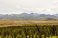
Eska Mountain and Granite Peak surrounding Sutton in late fall
|
|

Location in Matanuska-Susitna Borough and the state of Alaska
|
|

Sutton-Alpine, Alaska
Location in Alaska
|
|
| Country | United States |
| State | Alaska |
| Borough | Matanuska-Susitna |
| Area | |
| • Total | 58.14 sq mi (150.57 km2) |
| • Land | 57.60 sq mi (149.19 km2) |
| • Water | 0.54 sq mi (1.39 km2) |
| Population
(2020)
|
|
| • Total | 1,038 |
| • Density | 18.02/sq mi (6.96/km2) |
| Time zone | UTC-9 (Alaska (AKST)) |
| • Summer (DST) | UTC-8 (AKDT) |
| ZIP code |
99674
|
| Area code(s) | 907 |
| FIPS code | 02-74525 |
Sutton is a small community in Alaska, a state in the United States. It's located in the Matanuska-Susitna Borough. In 2020, about 1,038 people lived here.
Sutton is known as a "census-designated place" (CDP). This means it's an area that the government counts for population, but it's not an official city or town. The community includes the areas of Sutton, Eska, and Jonesville, which used to be coal mining towns.
The native people of this area, the Ahtna and Dena'ina Athabascans, have their own names for Sutton. In Ahtna, it's Ts'es Tac'ilaexde, and in Dena'ina, it's Ts'es Tuk'ilaght. Both names mean 'where fish run among rocks'.
Contents
Geography of Sutton-Alpine
Sutton-Alpine is in the southeastern part of the Matanuska-Susitna Borough. It is about 52 to 72 miles (84–116 km) northeast of Anchorage. You can find it along Alaska Route 1, which is also called the Glenn Highway.
The community sits between Buffalo Soapstone to the west and Chickaloon to the east. The Matanuska River flows along the southern edge of Sutton-Alpine. Palmer, which is the main town of the borough, is about 14 miles (23 km) to the southwest.
The total area of Sutton-Alpine is about 58.1 square miles (150.57 square kilometers). Most of this area is land, about 57.6 square miles (149.19 square kilometers). A small part, about 0.5 square miles (1.39 square kilometers), is water.
Climate in Sutton
Sutton has a type of weather called a continental subarctic climate. This means it has very cold winters with lots of snow. The summers are usually mild, not too hot.
| Climate data for Sutton | |||||||||||||
|---|---|---|---|---|---|---|---|---|---|---|---|---|---|
| Month | Jan | Feb | Mar | Apr | May | Jun | Jul | Aug | Sep | Oct | Nov | Dec | Year |
| Record high °F (°C) | 49 (9) |
54 (12) |
55 (13) |
78 (26) |
82 (28) |
85 (29) |
85 (29) |
85 (29) |
73 (23) |
67 (19) |
49 (9) |
52 (11) |
85 (29) |
| Mean daily maximum °F (°C) | 22.9 (−5.1) |
28.2 (−2.1) |
37.2 (2.9) |
48.9 (9.4) |
60.9 (16.1) |
66.9 (19.4) |
68 (20) |
65.7 (18.7) |
57.2 (14.0) |
42.5 (5.8) |
28.1 (−2.2) |
23.6 (−4.7) |
45.8 (7.7) |
| Mean daily minimum °F (°C) | 9.1 (−12.7) |
11.5 (−11.4) |
17.3 (−8.2) |
25 (−4) |
32.4 (0.2) |
40.7 (4.8) |
46.3 (7.9) |
44.1 (6.7) |
35.9 (2.2) |
25.9 (−3.4) |
14.8 (−9.6) |
10 (−12) |
26.1 (−3.3) |
| Record low °F (°C) | −40 (−40) |
−43 (−42) |
−31 (−35) |
−19 (−28) |
11 (−12) |
17 (−8) |
29 (−2) |
25 (−4) |
12 (−11) |
−21 (−29) |
−27 (−33) |
−36 (−38) |
−43 (−42) |
| Average precipitation inches (mm) | 1.08 (27) |
1.04 (26) |
0.83 (21) |
0.54 (14) |
0.86 (22) |
1.47 (37) |
2.48 (63) |
2.95 (75) |
3.04 (77) |
1.66 (42) |
1.54 (39) |
1.54 (39) |
19.04 (484) |
| Average snowfall inches (cm) | 12.3 (31) |
11 (28) |
8.7 (22) |
3.5 (8.9) |
1 (2.5) |
0 (0) |
0 (0) |
0 (0) |
0.2 (0.51) |
6.4 (16) |
14 (36) |
17.8 (45) |
74.8 (190) |
| Average precipitation days | 8 | 6 | 5 | 4 | 8 | 11 | 16 | 17 | 15 | 9 | 8 | 9 | 116 |
Population of Sutton-Alpine
| Historical population | |||
|---|---|---|---|
| Census | Pop. | %± | |
| 1940 | 14 | — | |
| 1960 | 162 | — | |
| 1970 | 76 | −53.1% | |
| 1980 | 182 | 139.5% | |
| 1990 | 308 | 69.2% | |
| 2000 | 1,080 | 250.6% | |
| 2010 | 1,447 | 34.0% | |
| 2020 | 1,038 | −28.3% | |
| U.S. Decennial Census | |||
Sutton-Alpine first appeared on the U.S. Census in 1940. Back then, it was just called "Sutton" and had only 14 people. It didn't show up in 1950, but it returned in 1960 and 1970.
In 1980, Sutton became a census-designated place (CDP). In 2000, its name changed to Sutton-Alpine. The area now includes the old mining villages of Eska and Jonesville.
In 2000, there were 1,080 people living in Sutton-Alpine. There were 278 households, which are groups of people living together. About 34.9% of these households had children under 18. The average household had about 2.53 people.
The population had a mix of ages. About 19.3% were under 18 years old. About 40.7% were between 25 and 44 years old. The median age was 37 years. This means half the people were younger than 37 and half were older.
History of Sutton
The very first people to live in the Sutton area were the Ahtna and Dena'ina Athabascans. They had their own names for the place, Ts'es Tac'ilaexde and Ts'es Tuk'ilaght. Both of these names mean 'where fish run among rocks'. This tells us that fishing was likely very important to them.
Images for kids
-
Landscape in Sutton

See also
 In Spanish: Sutton-Alpine (Alaska) para niños
