
Anchor River facts for kids
Quick facts for kids Anchor River |
|
|---|---|

Location of the mouth of the Anchor River in Alaska
|
|
| Country | United States |
| State | Alaska |
| Borough | Kenai Peninsula |
| Physical characteristics | |
| Main source | Kenai Peninsula 1,424 ft (434 m) 59°48′19″N 151°10′27″W / 59.80528°N 151.17417°W |
| River mouth | Cook Inlet Anchor Point, 14 miles (23 km) northwest of Homer 16 ft (4.9 m) 59°46′58″N 151°51′38″W / 59.78278°N 151.86056°W |
| Length | 30 mi (48 km) |
The Anchor River is a cool stream located on the Kenai Peninsula in Alaska, a big state in the United States. It starts near Bald Mountain on the eastern side of the peninsula. The river flows generally west for about 30 miles (48 km) (30 miles). It eventually empties into Cook Inlet near a town called Anchor Point. This spot is about 14 miles (23 km) (14 miles) northwest of Homer.
As the river flows, its middle parts go through a special area. This area is called the Anchor River and Fritz Creek Critical Habitat Area. It's a protected place for fish and other wildlife, especially large animals like moose. Further down, the river crosses North Fork Road and then the Sterling Highway. Finally, it reaches Anchor Point and the Anchor River State Recreation Area right by the coast.
Contents
Anchor River State Recreation Area
The Anchor River State Recreation Area is a very popular place, especially in the summer. Many people come here to camp and enjoy fishing.
Fishing Fun
During the summer, different types of salmon swim up the river. This makes it a great spot for fishing! You can also find steelhead here. These are a type of rainbow trout that live in the ocean but come back to the river. Many anglers practice catch-and-release fishing for steelhead. This means they catch the fish and then carefully let them go back into the water.
Cool Views and History
Anchor Point is special because it's the most western point in the U.S. highway system. From the beach at the recreation area, you can see amazing views. You can spot the tall peaks of the Aleutian Range in the distance. This includes volcanoes like Mount Augustine, Mount Iliamna, and Mount Redoubt. Long ago, in the 1890s, people even searched for gold in this area!
Boat Launching
Anchor Point doesn't have a big harbor for boats. But it has a unique way to launch boats from the beach. They use special tractors to pull boats from the shore out into the deeper water. This makes it easy for people to get their boats out into Cook Inlet.
Images for kids
-
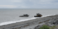
Tractor-launching a boat

