Hauraki District facts for kids
Quick facts for kids
Hauraki District
|
|
|---|---|
|
Territorial authority district
|
|

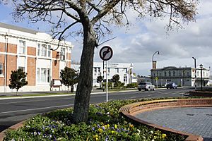
Normanby Road, Paeroa, with the former Paeroa Post Office building at left
|
|
 |
|
| Country | New Zealand |
| Region | Waikato Region |
| Wards | Paeroa Plains Waihi |
| Seat | Paeroa |
| Area | |
| • Land | 1,270.12 km2 (490.40 sq mi) |
| Population
(June 2023)
|
|
| • Total | 22,400 |
| Time zone | UTC+12 (NZST) |
| • Summer (DST) | UTC+13 (NZDT) |
| Postcode(s) |
Map of postcodes
|
| Website | Hauraki District Council |
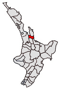
The Hauraki District is a special area in New Zealand that is managed by its own local government, the Hauraki District Council. It is located within the Waikato Region and its main town, where the council is based, is Paeroa.
This district stretches from the southwest coast of the Firth of Thames all the way southeast towards the town of Te Aroha. It also reaches eastwards to the Bay of Plenty coast, covering the lower part of the Coromandel Peninsula. The rest of the peninsula is part of another district called Thames-Coromandel District.
Some cool places and features you can find in the Hauraki District include the amazing Karangahake Gorge, the beach at Whiritoa, the wide open Hauraki Plains, the town of Ngatea, and Waihi, which is famous for its gold mining history.
Contents
Who Lives in Hauraki District?
The Hauraki District covers about 1,270 square kilometers (that's about 490 square miles). As of the 2023 New Zealand census, around 21,318 people call this district home. This means there are about 17 people living in each square kilometer.
The population has been growing! Since the 2018 census, the number of people living here has increased by 6.5%. Compared to 2013, it's grown by almost 20%.
Age and Background
The average age of people in Hauraki District is about 47.6 years old. This is a bit older than the national average for New Zealand, which is 38.1 years.
Here's a quick look at the age groups:
- About 17.8% of people are under 15 years old.
- Around 14.1% are between 15 and 29 years old.
- Most people, about 42.4%, are between 30 and 64 years old.
- About 25.7% of people are 65 years or older.
When it comes to different backgrounds, people in Hauraki District come from many places:
- Most people (83.6%) identify as European or Pākehā.
- About 24.1% identify as Māori.
- Smaller groups include Pasifika (3.6%) and Asian (4.5%) people.
- Some people identify with more than one background.
About 13.1% of the people living in Hauraki District were born outside of New Zealand.
Beliefs and Work
When asked about their religious beliefs, many people (54.9%) said they had no religion. About 31.4% identified as Christian. Smaller numbers followed Māori religious beliefs, Hinduism, Islam, Buddhism, or other religions.
For those aged 15 and older, about 41.2% work full-time, and 15.6% work part-time.
District Wards
The Hauraki District is divided into three main areas called wards. These help manage local services for different parts of the district.
- Plains Ward: This is the largest ward by area.
- Paeroa Ward: This ward includes the main town of Paeroa.
- Waihi Ward: This ward includes the town of Waihi.
Towns and Communities
The Hauraki District is made up of many different towns, smaller communities, and rural areas. Here are some of the main ones, grouped by their wards:
|
|
|
 | Stephanie Wilson |
 | Charles Bolden |
 | Ronald McNair |
 | Frederick D. Gregory |

