Hayle Estuary facts for kids
Quick facts for kids Hayle Estuary |
|
|---|---|

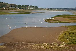
Looking towards Lelant from the causeway
|
|
| Location | Hayle, Cornwall |
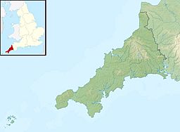
| Coordinates | 50°11′31″N 5°26′06″W / 50.192°N 5.435°W |
| Native name | Heyl Error {{native name checker}}: parameter value is malformed (help) |
| River sources | Angarrack and Hayle |
| Primary outflows | St Ives Bay |
| Designation | Site of Special Scientific Interest (SSSI) |
The Hayle Estuary (which is called Heyl in Cornish, meaning 'estuary') is a special watery area in west Cornwall, England. An estuary is where a river meets the sea, and the water is a mix of fresh and salty.
This estuary is one of the few natural harbours on the north coast of south-west England. For a very long time, it was important for trading goods and for people to travel. It also helped new ideas spread around.
The main part of the estuary is the channel of the River Hayle. There are also other areas where the tide comes in, like Lelant Saltings, Copperhouse Creek, and Carnsew Pool.
The whole area is part of a special protected place called the Hayle Estuary and Carrack Gladden Site of Special Scientific Interest. This means it's important for its wildlife and nature. The Royal Society for the Protection of Birds (RSPB) also looks after a nature reserve here.
Contents
A Look Back: Hayle's History
The Hayle Estuary has been important for a very long time. Because it was a good natural harbour, people used it for trade and travel.
Ancient Times and Early Christianity
A very old hillfort, a type of ancient fort on a hill, can be seen overlooking the estuary at Carnsew. This fort is from a time before written history.
Archaeologists have found old items around the estuary that show links to Ireland. In the early medieval period, which was after the Roman Empire, some of the first signs of Christianity in Cornwall were found here. These also had strong Irish connections.
There's an old Christian memorial stone called the "Cunaide Stone" on the lower part of the hillfort. It was found in 1843. Experts believe it's from the 5th century AD. Its design might have come from Europe, and the name on it could be Irish.
Religion and trade continued in the early medieval period. People would go on pilgrimages to places like St Michael's Mount. However, trade slowed down later because the estuary started to get blocked with silt. This silt came from tin mining happening further up the river.
Hayle's Industrial Boom
In 1757, the Cornish Copper Company moved to Hayle. The next year, they built a copper smelting factory on the eastern side of the estuary, in an area now called Copperhouse Pool.
It was hard for ships to get to the open sea from here. So, in 1769, they finished building a canal and a dock. This is one of the oldest industrial buildings still standing in Hayle.
In 1779, Harvey's Foundry was started by John Harvey. It was built near Penpol Creek to help the local mines. Harvey's built South Quay in 1819. This made the shipping channels get blocked with more silt. To fix this, they used the water from Copperhouse Pool to wash the silt away.
In 1834, Carnsew Pool was created. This happened after the Cornish Copper Company built East Quay, which caused Harvey's deep water channels to fill with silt. The sides of Carnsew Pool were built using rubble and slag, which is waste from smelting.
A new pier was also built to send water through special gates, called sluices, into the estuary. This helped to flush the silt out of the river channel near Harvey's foundry. This clever system kept the port working, allowing the two rival companies to grow their businesses.
Harvey's not only built steam engines but also exported goods overseas. They even built and broke up ships. Harvey's built 79 ships in Hayle, including the SS Ramleh in 1891. At 4000 tons, it was the largest ship ever built in Cornwall!
These two competing companies helped Hayle become a very important industrial port in the 18th and 19th centuries. They supported the tin and copper mining in West Cornwall.
Around 1811, a road called Sea Lane (or Black Road) was built across Copperhouse Creek. This made it easier to get between the Copperhouse works and the company's main shipping area at North Quay. Many of the buildings around the creek were made from blocks of slag, which was waste material from the smelter. This gave them a unique look and led to the name "Black Road."
Getting Around: Transport
In 1825, a special law was passed to create the Hayle Bridge Causeway and Turnpike Trust. This group had to build a bridge, a raised road (causeway), and a toll road (turnpike) over the Hayle River. This road went from Griggs Quay in the west to Phillack in the east.
The turnpike was needed to make it easier to transport copper ore to the port at Hayle so it could be shipped out. More laws were passed in 1837 and 1839 to extend these toll roads.
The running of the turnpike was given to the person who offered the most money in a public auction. In 1880, the winning bid was £591 and 10 shillings. In 1885, the toll road system ended. The White House, which was the tollhouse, was then sold.
The Hayle Railway was built in the 1830s. It was a single-track railway used to move minerals from the mines in Camborne and Redruth. Its western end was at Penpol. It followed the northern shore of Copperhouse Pool and then went up a steep slope at Angarrack towards Redruth.
 | Charles R. Drew |
 | Benjamin Banneker |
 | Jane C. Wright |
 | Roger Arliner Young |


