River Hayle facts for kids
Quick facts for kids River Hayle |
|
|---|---|

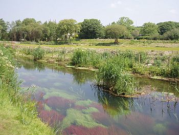
River Hayle near St Erth
|
|

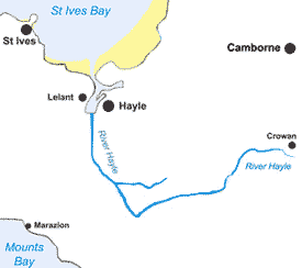
Map of the course of the River Hayle
|
|
| Country | United Kingdom |
| Region | Cornwall |
| Physical characteristics | |
| Main source | Crowan 50°9′25.2″N 5°16′58.8″W / 50.157000°N 5.283000°W |
| River mouth | Hayle Estuary Hayle, St Ives Bay 50°11′31″N 5°26′6″W / 50.19194°N 5.43500°W |
The River Hayle is a small river in West Cornwall, England. Its name, Heyl, means "estuary" in the Cornish language. The river flows into St Ives Bay at the town of Hayle, on Cornwall's Atlantic coast.
The River Hayle is about 12 miles (19 kilometres) long. It starts near the village of Crowan. For about 5 miles, it flows west. This brings the river close to the south coast, near Marazion. Then, it goes through a steep, wooded valley. This valley is north of a rocky area called Trescowe Common. After that, the river turns sharply north near Relubbus. It continues north for the last six miles to its estuary, passing by St Erth.
Exploring the Hayle Estuary
The Hayle Estuary is where the River Hayle meets the sea. An estuary is a special area where fresh river water mixes with salty ocean water. This area includes a former port on the east side. It also has a large area of salt marsh called Lelant Saltings on the west.
The Importance of the Estuary
The port in the estuary was once very important for industries in Hayle. Today, Lelant Saltings is a vital home for many birds. The Royal Society for the Protection of Birds (RSPB) manages a nature reserve there. This helps to protect the birds and their habitat.
Areas around the estuary are special places for nature. They are called Sites of Special Scientific Interest (SSSIs). The Hayle Estuary is part of the Hayle SSSI. This means it is protected because of its unique wildlife and natural features.
 | Aaron Henry |
 | T. R. M. Howard |
 | Jesse Jackson |

