
Helena Historic District (Helena, Montana) facts for kids
Quick facts for kids |
|
|
Helena Historic District
and Boundary Increases I and II |
|

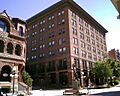
Atlas Block, within the Helena Historic District
|
|

Location in Montana

Location in the United States
|
|
| Location | Irregular pattern from Hauser Boulevard to Acropolis and between Garfield and Rodney Sts., Helena, Montana; also roughly bounded by Cruse, Neill, and Park Aves., and Lawrence; also bounded by E. Sixth, N. Davis, Broadway, and N. Rodney Sts. |
|---|---|
| Area | 150 acres (61 ha) (original); 22 acres (8.9 ha) (boundary increase I); 10 acres (4.0 ha) (boundary increase II) |
| Built | 1864 |
| Architect | Multiple |
| Architectural style | Art Deco, French Renaissance, Gothic Revival, Late Victorian, Romanesque Revival, Western Commercial |
| NRHP reference No. | 72000737; 90000934; 93001001 |
| Added to NRHP | June 2, 1972 (original) June 14, 1990 (boundary increase I) October 7, 1993 (boundary increase II) |
The Helena Historic District (HHD) is a special area in Helena, Montana, United States. The government has officially recognized it for its important history. It was first created in 1972. Since then, its boundaries, or edges, have been changed a few times in 1990 and 1993. When it was first set up, the HHD had two separate parts: one called "Downtown" and another called "West Residential."
Contents
Exploring Helena's Historic Downtown
Helena began in its downtown area. On July 14, 1864, four miners found gold in a creek. This creek is now Helena's main street, called Last Chance Gulch. This discovery started a huge building boom that lasted 30 years. Helena soon became the state capital.
How Downtown Helena Grew
The city grew from south to north along Last Chance Gulch. This means you can see how building styles changed over time. At the southern end, the road is narrow with small log and stone buildings. Further north, the road gets wider and has large stone homes.
After a financial crisis in 1893, fewer big downtown buildings were constructed. This crisis also caused local silver mines to close. Because of this, downtown Helena has a clear difference between its older and newer parts. Many newer buildings were small and had a simple "false front" style.
Important Early Buildings
In 1972, when the district was first recognized, many important early buildings still stood. These included the Electric and Power Blocks, the Helena Athletic Association, and the Atlas Block. Other notable buildings were the Diamond Block, the Wheat Building, and the Lewis and Clark County Courthouse.
However, a big fire in 1928 destroyed many original buildings. These included the Granite and New York Store blocks. More buildings were damaged or ruined by the 1935 Helena earthquake.
Architectural Styles in Downtown Helena
Helena's first business area was along State, Edwards, and Broadway Streets. But fires in 1869, 1872, and 1874 destroyed much of it. Many buildings built after these fires used the Western Commercial style. This style featured beautiful brickwork and simple designs.
Other buildings showed different styles. The Parchen Drug Building and the Penn-Block Bristol Hotel had a French Renaissance look. The Denver Block and Sands Brothers Dry Goods were built in the Romanesque Revival style. By the mid-1880s, many architects had come to Helena. Some were influenced by the "Chicago school of architecture." You can see this influence in buildings like the Atlas Building and the Securities Building.
Changes from Urban Renewal
In the early 1970s, a big project called "urban renewal" changed the area a lot. About 240 buildings in the original Helena Historic District were torn down. Sixty-one of these were historically important. Most were commercial buildings in the southeastern part of the district.
Many people in Helena were upset by this project. They felt it was as bad as the 1935 earthquake. They believed many "insipid" (boring) new buildings replaced important historic ones. However, many significant buildings like the Atlas Block and the Placer Hotel are still standing today.
The West Residential Section

The West Residential section is on the lower part of Mount Helena, west of downtown. The streets here are lined with trees and stone walls. Many homes in this area were built in the late 1800s.
This section includes large, grand homes, or mansions. Some were once owned by important people like United States Senator Thomas C. Power. The architecture of these homes is very diverse, meaning they have many different styles.
Changes and Expansions to the District
When many buildings were torn down during urban renewal, the southeastern part of the original downtown district was removed from the historic list. In 1990, a new area of about five blocks was added north of the original downtown.
New Additions and a Pedestrian Mall
The boundaries of the residential section did not change at this time. However, a wide, modern street called Cruse Avenue was built. It was meant to help traffic flow, but it also separated the residential district from downtown.
Important buildings like St. Peter's Episcopal Cathedral and the First Unitarian Church (now Grandstreet Theater) were included in this updated district. The changes also meant that the period of historical importance was extended to 1948. This recognized important changes that happened in the early 1900s. Also, the south end of Last Chance Gulch was closed to cars and turned into a walking mall.
Buildings Lost to Urban Renewal
During urban renewal, about 150 buildings in a seven-block area were torn down. An entire street, Wall Street, was removed. This area was then filled with three modern buildings and a park. This demolition also led to the loss of West State Street and what was left of Helena's Chinatown. Other lost buildings included the Electric Block and the Marlow Theater, which was a very controversial demolition.
The 1993 Boundary Increase
In 1993, about three blocks of mixed commercial and residential buildings were added to the district. These buildings are centered on North Rodney Street, east of the downtown area. They represent development from 1878 to 1948.
Many of these structures were built in the late 1800s. People moved to this area because it was considered safer from the earlier Helena fires. Several businesses here were built by members of Helena's Jewish community. This activity was highest in the 1890s but slowed down after the financial crisis of 1893. Construction slowly started again after 1900.
Images for kids
-
Placer Hotel and Securities Building, downtown Helena
-
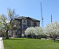
Lewis and Clark County Courthouse


