Henderson, Nebraska facts for kids
Quick facts for kids
Henderson, Nebraska
|
|
|---|---|

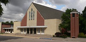
Bethesda Mennonite Church in Henderson. The majority of the city's residents are descended from 35 Mennonite families who settled the area in 1874.
|
|

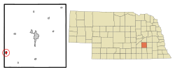
Location of Henderson, Nebraska
|
|
| Country | United States |
| State | Nebraska |
| County | York |
| Area | |
| • Total | 0.66 sq mi (1.71 km2) |
| • Land | 0.66 sq mi (1.71 km2) |
| • Water | 0.00 sq mi (0.00 km2) |
| Elevation | 1,719 ft (524 m) |
| Population
(2020)
|
|
| • Total | 1,080 |
| • Density | 1,638.85/sq mi (632.73/km2) |
| Time zone | UTC-6 (Central (CST)) |
| • Summer (DST) | UTC-5 (CDT) |
| ZIP code |
68371
|
| Area code(s) | 402 |
| FIPS code | 31-22080 |
| GNIS feature ID | 2394349 |
Henderson is a small city located in York County, Nebraska, in the United States. In 2020, about 1,080 people lived there. Many of Henderson's residents are descendants of 35 Mennonite families who first settled in the area in 1874.
History of Henderson
Henderson started as a town in 1887. This happened when the Fremont, Elkhorn & Missouri Valley Railroad built its tracks through the area. The town was named after David Henderson, who was one of the first settlers there. Henderson officially became an incorporated city in 1899.
Geography of Henderson
Henderson is located entirely on land. According to the United States Census Bureau, the city covers a total area of about 0.56 square miles (1.45 square kilometers).
Population Changes
The population of Henderson has changed over the years. Here's how many people lived in the city during different census years:
| Historical population | |||
|---|---|---|---|
| Census | Pop. | %± | |
| 1900 | 208 | — | |
| 1910 | 391 | 88.0% | |
| 1920 | 485 | 24.0% | |
| 1930 | 480 | −1.0% | |
| 1940 | 495 | 3.1% | |
| 1950 | 536 | 8.3% | |
| 1960 | 730 | 36.2% | |
| 1970 | 901 | 23.4% | |
| 1980 | 1,072 | 19.0% | |
| 1990 | 999 | −6.8% | |
| 2000 | 986 | −1.3% | |
| 2010 | 991 | 0.5% | |
| 2020 | 1,080 | 9.0% | |
| U.S. Decennial Census | |||
See also
 In Spanish: Henderson (Nebraska) para niños

