Heron Neck Light facts for kids
 |
|
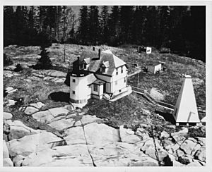
| US Coast Guard photo ca 1954 | |
|
|
|
| Location | Penobscot Bay |
|---|---|
| Coordinates | 44°1′30.4″N 68°51′43.8″W / 44.025111°N 68.862167°W |
| Year first constructed | 1854 |
| Year first lit | 1854 |
| Automated | 1982 |
| Tower shape | Conical Tower attached to Dwelling |
| Markings / pattern | White |
| Focal height | 92 feet (28 m) |
| Range | 9 nautical miles (17 km; 10 mi) & 7 nautical miles (13 km; 8.1 mi) |
| Characteristic | F R with W sector |
| Fog signal | HORN 1 every 30s |
| USCG number | 1-3760 |
The Heron Neck Light is a historic lighthouse located on Green's Island. This island is found in Vinalhaven, Maine, at the southern tip of Penobscot Bay. Lighthouses like this one help ships find their way safely.
This light was first lit in 1854. It helped guide boats to Vinalhaven's main port. It also marked the Hurricane Channel, which goes northwest from Heron's Neck. The light became automatic in 1984, meaning no one had to live there to operate it anymore. It was added to the National Register of Historic Places in 1988. This means it is an important historical site.
Where is Heron Neck Light?
The town of Vinalhaven is mostly on a large island. This island is part of the Fox Island group. It sits in the middle of southern Penobscot Bay. Many smaller islands and rocky areas surround it.
Vinalhaven's main town and port are in Carver's Harbor. This harbor is on the south side of Vinalhaven Island. Green's Island is one of the bigger islands nearby. It is southwest of Carver's Harbor. The Heron Neck Light stands at the very southern end of Green's Island. This spot is called Heron Neck. To the west of Green's Island is a channel. This channel separates it from other small islands and rocks. Hurricane Island is the largest of these.
What Does Heron Neck Light Look Like?
The lighthouse area includes several buildings. There is the lighthouse tower itself. A house for the lighthouse keeper is connected to it. There is also an oil house and a fog signal building. These buildings are on the southern side of Heron Neck. This side is open to the sea. A boat landing is on the northern side. This side is more protected.
The lighthouse tower is round and made of brick. On top, there is a lantern room. This room has many sides. An iron fence and railing go around it. A covered walkway connects the tower to the keeper's house. The keeper's house is a wooden building. It has one and a half stories and is shaped like an "L."
The oil house is a small stone building. It has a pointed roof. Most oil houses in Maine are made of brick. So, this stone one is a bit different. North of these buildings is the fog signal. This building was built in the mid-1900s. It is square with a sloped roof.
History of Heron Neck Light
The plan for the Heron Neck Light was approved in 1853. The light began working in 1854. The lighthouse tower you see today is the original one. The keeper's house was built later, in 1895-1896. It replaced the first house, which was made of brick.
In the late 1800s, Vinalhaven was a fishing and farming town. But it grew a lot during that time. It became a popular place for vacations. It also became known for its granite quarries. Quarries are places where stone is dug out of the ground.
The light first used a special lens called a Fresnel lens. This lens helped make the light very bright. In 1984, the light became automated. This means machines now run the light. No one needs to live there to keep it working.
 | Victor J. Glover |
 | Yvonne Cagle |
 | Jeanette Epps |
 | Bernard A. Harris Jr. |


