
High Falls on the Oswegatchie River facts for kids
Quick facts for kids High Falls |
|
|---|---|

High Falls on the Oswegatchie
|
|
| Lua error in Module:Infobox_mapframe at line 185: attempt to index field 'wikibase' (a nil value). | |
| Location | Adirondack Park, Fine, New York, United States |
| Coordinates | 44°04′07″N 74°54′37″W / 44.0686737°N 74.9101860°W |
| Elevation | 1,601 ft (488 m) |
| Total height | 15 feet (4.6 m) |
High Falls is a beautiful waterfall located on the Oswegatchie River. It's found in a wild area called the Five Ponds Wilderness. This waterfall is in the town of Fine, which is part of the huge Adirondack Park in St. Lawrence County, New York.
The water drops about 20 feet (6.1 m) down. You can reach High Falls by canoe or by walking on special hiking trails. The nearest road is almost six miles (about 9 km) away, near a place called Wanakena.
To get there by trail, you can take a short path from the High Falls Loop Trail. If you prefer canoeing, you can paddle along the Oswegatchie River. The waterfall is considered a special scenic area by New York State.
History of High Falls
At High Falls, the Oswegatchie River flows over very old granite rocks. These rocks were shaped by glaciers long ago. The area around the falls is covered with white pine trees.
You might expect to see a very dense, old forest here. However, strong windstorms in 1950 and 1995 damaged this part of the Five Ponds Wilderness. The area was also used for logging in the past. You can still find old logging tools and structures nearby.
A special railroad for logging once ran between Wanakena and High Falls. The Rich Lumber Company built this railroad around 1902. They used it until 1912 to transport cut trees.
The part of the Five Ponds Wilderness south of High Falls is very special. It has the largest area of untouched forest in the northeastern United States. It is also the biggest area in New York state without any hiking trails.
Old Trails and Bridges
Today, there is no longer a bridge at High Falls. If you want to explore the region further south, you will need a canoe. The path around the waterfall for canoes is quite short.
The old bridge was part of a trail called the Red Horse Trail. This trail used to go from Wanakena all the way to the Beaver River. That's about ten miles (16 km) south of the falls.
The Red Horse Trail was one of the oldest hiking trails in the Adirondack Park. It was created by the Adirondack Mountain Club (ADK) in the 1920s. Now, only a five-and-a-half mile (9 km) section of the trail remains. This part runs north from Big Burnt Lake / Trout Pond.
The Red Horse Trail also crossed an even older path called the Old Military Road. This road was built between 1812 and 1815. It followed a much older trail used by Native Americans.
Gallery
-
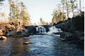
High Falls, December 1998
-
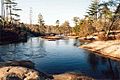
Above the High Falls on the Oswegatchie
-
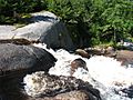
August, 2008


Maps
USGS 7.5' Newton Falls 1:24,000
