
Hillsboro, Maryland facts for kids
Quick facts for kids
Hillsboro, Maryland
|
|||
|---|---|---|---|

St. Paul's Episcopal Church in Hillsboro
|
|||
|
|||

Location of Hillsboro, Maryland
|
|||

Hillsboro, Maryland
Location in Maryland

Hillsboro, Maryland
Location in the United States
|
|||
| Country | |||
| State | |||
| County | |||
| Incorporated | 1853 | ||
| Area | |||
| • Total | 0.14 sq mi (0.35 km2) | ||
| • Land | 0.14 sq mi (0.35 km2) | ||
| • Water | 0.00 sq mi (0.00 km2) | ||
| Elevation | 39 ft (12 m) | ||
| Population
(2020)
|
|||
| • Total | 128 | ||
| • Density | 948.15/sq mi (365.27/km2) | ||
| Time zone | UTC-5 (Eastern (EST)) | ||
| • Summer (DST) | UTC-4 (EDT) | ||
| ZIP code |
21641
|
||
| Area code(s) | 410 | ||
| FIPS code | 24-39175 | ||
| GNIS feature ID | 0584985 | ||

Hillsboro is a small town in Caroline County, Maryland, United States. In 2020, about 128 people lived there. It's known for its history. Two important places, Daffin House and St. Paul's Episcopal Church, were added to the National Register of Historic Places in 1975.
Contents
History of Hillsboro
Hillsboro is the oldest town in Caroline County. People lived here a long time ago. Records show that an Anglican church was built on the Tuckahoe River as early as 1694.
Hillsboro was once a busy trading spot. It had a tobacco warehouse and several general stores. There was also a shoe factory and a place to eat and drink called a tavern.
A famous painter named Charles Willson Peale lived in Hillsboro for a short time. He is known for his portraits and museums.
The first newspaper in Caroline County was printed in Hillsboro. It was published in 1831 by the Lucas Brothers.
Hillsboro was first called Tuckahoe Bridge. It was later renamed to honor Lord Hillsboro of the Calvert Family.
The town also hosted the Tri-County fair. This was a big event where people from three counties would meet. It was also a place for important political meetings.
Getting Around Hillsboro
Most people travel to and from Hillsboro by car. The main road that goes through the town is Maryland Route 404 Alternate. Other bigger roads, Maryland Route 404 and Maryland Route 480, are just outside the town.
Geography and Climate
Hillsboro is located at coordinates 38°54′59″N 75°56′29″W / 38.91639°N 75.94139°W. This means it's in the northern part of the world, west of the prime meridian.
The town covers a total area of about 0.35 square kilometers (0.14 square miles). All of this area is land, with no large bodies of water.
Hillsboro's Weather
Hillsboro has a type of weather called a humid subtropical climate. This means the summers are hot and humid. The winters are usually mild, not too cold. This climate is often called "Cfa" on weather maps.
Population Facts
| Historical population | |||
|---|---|---|---|
| Census | Pop. | %± | |
| 1880 | 264 | — | |
| 1890 | 174 | −34.1% | |
| 1900 | 196 | 12.6% | |
| 1910 | 209 | 6.6% | |
| 1920 | 222 | 6.2% | |
| 1930 | 200 | −9.9% | |
| 1940 | 181 | −9.5% | |
| 1950 | 179 | −1.1% | |
| 1960 | 201 | 12.3% | |
| 1970 | 177 | −11.9% | |
| 1980 | 180 | 1.7% | |
| 1990 | 164 | −8.9% | |
| 2000 | 163 | −0.6% | |
| 2010 | 161 | −1.2% | |
| 2020 | 128 | −20.5% | |
| U.S. Decennial Census | |||
2010 Census Information
In 2010, there were 161 people living in Hillsboro. These people lived in 68 different homes. Most of the people (96.3%) were White. A smaller number (2.5%) were African American. About 3.1% of the population identified as Hispanic or Latino.
The average age of people in Hillsboro was about 38 years old. About 22% of the residents were under 18 years old. Around 11% were 65 years or older. Slightly more than half of the residents were female (52.8%).
Neighborhoods and Communities
Hillsboro includes several smaller communities:
- Haketts Garden
- Hillsboro Estates
- Thomas Town
- Lor-J-Estates
Images for kids
-
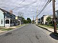
Maryland Route 404 Alternate in Hillsboro
_at_Maple_Avenue_in_Hillsboro,_Caroline_County,_Maryland.jpg)
See also
 In Spanish: Hillsboro (Maryland) para niños
