
History of Braidwood, New South Wales facts for kids
Quick facts for kids Braidwood and Its Setting |
|
|---|---|
.jpg)
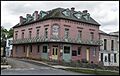
Braidwood Hotel, 2017
|
|
| Location | Braidwood, Queanbeyan-Palerang Region, New South Wales, Australia |
| Built | 1839– |
| Architect | Original survey and plan by James Larmer; 1839 |
| Owner | Alexandra Rea; Braidwood Hotel |
| Official name: Braidwood and Its Setting; Braidwood; Braidwood Farm; Jellamatong | |
| Type | state heritage (conservation area) |
| Designated | 3 April 2006 |
| Reference no. | 1749 |
| Type | Townscape |
| Category | Urban Area |
| Lua error in Module:Location_map at line 420: attempt to index field 'wikibase' (a nil value). | |
The history of Braidwood, New South Wales in Australia began in the early 1800s. This historic town is so special that its entire area is listed on important heritage registers. It was added to the former Register of the National Estate in 1980 and the New South Wales State Heritage Register in 2006. This means Braidwood is recognized for its unique past and how it looks today.
Contents
Braidwood's Early History
European Settlement Begins (1822–1839)
Exploring the Land
Europeans first explored the upper Shoalhaven River area in 1822. The Governor of New South Wales, Thomas Brisbane, wanted to find a path between the Limestone Plains and Batemans Bay. Reports of good land here soon encouraged people to settle.
How Land Was Given Out
In the 1820s, the government offered free land to settlers. For every £500 (about $800 AUD today) in money or livestock a settler had, they could get 640 acres of land. This was about one square mile. The largest grant was 2,560 acres. Captain Duncan Mackellar was one of the first settlers. He received 2,000 acres in 1822, choosing a property called "Strathallan." He moved there around 1829.
Planning the Colony
When Ralph Darling became Governor in 1825, he brought new plans from London. The colony was to be divided into large areas called counties, like in England. These counties would have a main town and smaller areas called parishes. This system was meant to help the Church of England and local government. However, it was hard to make this work in areas with very few people.
Early Land Surveys
Surveying the County of St Vincent began in 1824. By 1827, Assistant Surveyor Robert Hoddle (who later planned Melbourne) had mapped the Shoalhaven River. He was told to mark out land for new settlers. The Anglican Church received a large portion of the best land. This land was later taken back by the government around 1835. But its original boundaries still affect how the land looks today.
Other settlers who received land included:
- Dr Wilson RN (2,560 acres)
- Mr D Mackellar (2,000 acres)
- Mr Coghill (2,000 acres)
- Mr Ryrie (2,560 acres)
- Mr Francis Dixon (2,000 acres)
- Mr George Bunn (2,560 acres)
- Mr D Mackellar Junior (640 acres)
By 1828, about 90 Europeans lived in the area. But few landowners actually lived on their grants. After 1831, free land grants stopped. However, suitable land for farming was quickly sold.
Important Early Settlers
Three landowners were very important in Braidwood's early days.
- Captain Duncan Mackellar
Captain Duncan Mackellar and his nephew moved to Strathallan around 1829. They combined their land grants and bought more, owning 7,250 acres. Mackellar had one of the largest properties. He was important in the area until he sold his land in 1836. Most of it went to John Coghill, who owned the land where Bedervale now stands. A smaller part was sold to Dr Thomas Braidwood Wilson.
- Thomas Braidwood Wilson
Wilson chose his 2,560 acres earlier, but he settled on "Braidwood Farm" in 1836. Wilson was a surgeon who brought convicts to New South Wales. He was given land near Lake George in 1825. He also received land on Monkittee and Flood creeks, which are tributaries of the Shoalhaven.
In 1833, part of Wilson's land was set aside for a future village. He was given extra land to make up for it. Wilson was a kind and forward-thinking person. He became a community leader. He even built the first courthouse in 1837–38. In 1840, Wilson asked the government to build a road from Braidwood to Huskisson. This would help transport wool to Sydney faster.
By 1841, Braidwood Farm had 141 residents. This was twice as many as Coghill's properties. A drought and economic problems caused Wilson to go bankrupt. He died in 1843. His land was sold to John Coghill. Coghill then owned all the land to the south, east, and north of the town. Wilson was buried on a hill overlooking Braidwood. A memorial and a large pine tree mark his grave.
- John Coghill
John Coghill was a smart businessman. He often visited his Bedervale property, which he got around 1827–28. He also served as a magistrate. In the 1830s, Coghill hired famous architect John Verge to design his house, which was finished around 1842. He also bought Strathallan.
Coghill's daughter, Elizabeth, married Robert Maddrell. They inherited Bedervale when Coghill died in 1853. Maddrell renamed Braidwood Farm to Mona, after his birthplace, the Isle of Man. Under his management, the estate grew to 33,000 acres. Much of this was farmed by tenant farmers. By 1860, Maddrell had 84 tenants. The Maddrell family owned the land around Braidwood for a long time. This is why the town's boundaries on the north, east, and south sides have stayed mostly the same.
The Nineteen Counties
In 1825, the government in London wanted to encourage more people to settle closer together. They limited the size of free land grants. Land was not supposed to be given out until it was surveyed. This caused problems because there weren't enough surveyors. To solve this, a "Limits of Location" line was drawn around existing settlements. Within this line, settlers could choose land without a prior survey. This area was divided into nineteen counties. Braidwood was in one of the southernmost counties.
How Towns Were Planned
The preferred way to survey land was to lay a rectangular grid over it. This was done in the United States and started in New South Wales in 1821. However, Governor Darling's instructions in 1825 changed this. Surveyors had to map natural features like rivers first. This meant that grid lines were often added to maps later. Because there were few skilled surveyors and equipment was old, some boundaries were not perfectly straight. This might explain why Braidwood's town boundary isn't perfectly parallel to its streets, especially on the eastern side.
Village Reserves
The plan was to have a village for every parish. So, surveyors set aside areas for future towns, about 5 miles apart. Hoddle chose a central spot for a village, which is where Braidwood is today. This reserve was called "Jillamatong," after a nearby mountain. It was located on Thomas Braidwood Wilson's land.
Police Districts
The British government wanted to set up local government like in England. But in New South Wales, police districts became the main form of local government. A paid police magistrate managed each district. Braidwood became the center of the "Braidwood Police District."
The Role of Convicts
In the 1828 census, about half of the 90 Europeans in the Braidwood area were convicts. Settlers could apply for convict servants to work their land. Convicts were a vital part of the workforce, especially in new and remote areas. The government wanted the colony to be seen as a place of punishment. Convicts had some rights, and minor offenses were handled by magistrates.
Need for a Local Court
Before Braidwood was a town, Captain Duncan Mackellar was appointed a magistrate in 1833. He had a policeman and a flogger to help him. Settlers often complained that there were only two unmounted police officers and no lockup in the large Braidwood district.
Courthouse Influences Town Location
Magistrates handled many government tasks and needed a courthouse and a jail. This often decided where a town would be built. The Surveyor General usually asked residents where a village reserve would best serve their needs.
When the government agreed to build a courthouse and lockup, they knew it would become the center of a new town. John Coghill suggested a more southerly location with better water. But Mackellar, as the main magistrate, wanted it closer to Strathallan. So, the "Jillamatong" reserve was chosen. Thomas Braidwood Wilson built the courthouse and lockup there in 1837–38.
A barracks for 6 mounted police and horses was also built. These buildings were the only structures shown on the map drawn before Braidwood was officially named a village on April 24, 1839. The town plan was a standard grid with wide streets. The first land auction was on July 9, 1840.
Convict transportation to New South Wales stopped in 1840. By the late 1840s, very few convicts were left in the region. The need for a judicial system to manage convicts directly led to Braidwood's location and its first buildings.
Braidwood Town Takes Shape
Early Town Planning
New South Wales towns were often planned with straight, rectangular streets. Governor Darling set rules in 1829 for uniform town planning. Officials disagreed on street width in hot climates. Governor Darling preferred wide streets for breezes. Main streets were 120 feet wide, and cross streets were 84 feet. Houses had to be set back from the street.
Braidwood is a great example of this early town planning. Its simple grid layout is still mostly the same. Surveyor Hoddle defined the town's outer edge. James Larmer drew the first plan. In 1839, Wilson asked for a park opposite the courthouse. He thought it would improve the area and be useful for residents. Surveyor General Mitchell agreed, and Larmer changed the plan.
The "Jillamatong" Village Reserve eventually became known as Braidwood, likely after Wilson's nearby "Braidwood Farm."
Growing the Town

Several buildings were put up around 1840–41, including the first Doncaster Inn. An economic downturn in the early 1840s slowed growth. But a business center slowly grew along Mackellar Street and Wallace Street. Being close to Monkittee Creek for water was important. Surveyor Larmer bought land and built the Royal Hotel around 1845. The Albert Buildings, now a flourmill, were shops. The Post Office and a store were on the corner of Mackellar and Wallace Streets. A District Council was set up in 1843.
The first steam mill was built in 1846 near Monkittee Creek.
Braidwood's population grew from 1,100 in 1841 to 1,429 in the police district by 1851. Only 212 people lived in the town itself. When gold was discovered in Araluen in 1851, Braidwood became even more important. The business center moved to the south end of Wallace Street as the road to Nelligen was surveyed.
Braidwood's "National School" opened in 1849. A permanent school building was finished in 1852. A brewery opened in 1851, along with many other businesses. The Joint Stock Bank was built in 1855 because of the gold rush. By 1857, there were three tanning factories. In 1861, 959 people lived in the town, and 8,199 were in the surrounding goldfields. The town's population reached 1,197 by 1871.
A small brick Anglican Church was built in 1856. A larger church was dedicated in 1892. Its tower was added in 1899, using granite from local quarries. About a third of the local population was Catholic, and St Bedes Church was finished by 1865. The Wesleyan Church was built in 1856, and the Presbyterian Church in 1861.
The Commercial Hotel was built in 1859. By 1866, Braidwood had eleven other hotels besides the Doncaster, Royal, and Commercial. The Court House Hotel and the Gold Diggers Home (now a bottle shop) still stand. Nomchong, who came from China to the goldfields, moved to Braidwood in 1879. Many less sturdy buildings were replaced with brick and granite ones in the late 1800s.
In 1861, a large two-story jail and jailer's home were built. The old police barracks were repaired for more police to control bushranging. The courthouse was also repaired. In 1865, a brick police barracks and stables were built next to the courthouse, still in use today. The telegraph station was built in 1864. In 1869, post and telegraph services merged, and the post office moved to its current, more central location.
A reservoir was created on Monkittee Creek to provide water for the town.
By 1885, the main business district had fully moved to the southern part of Wallace Street. The current Royal Hotel and some two-story shops were built then. In the 1870s and 80s, Braidwood hoped to get a railway connection. They even named a street Station Street and built the Railway Hotel. However, the gold years ended, and droughts and economic problems hit in the 1890s. Building in Braidwood's business area almost stopped.
Braidwood in the 1900s

The first car arrived in Braidwood in 1903. In 1913, Ryrie Park, once known as Market Square, was used for grazing. This damaged the trees and fences. In 1925, the Municipal Council organized "Back to Braidwood Celebrations" to mark 100 years of European settlement. This event helped clean up and beautify Ryrie Park. School children collected rubbish, and trees were donated.
In 1928, a company started building a power plant. It was meant to house a freezing works and ice factory. But the company failed during the Great Depression in 1931. Electric lighting for the main street was finally connected in February 1936. Braidwood was connected to the state power grid in 1957. Running water became available in 1955, but a sewerage system wasn't installed until 1966.
Braidwood's population was highest in 1901. Growth slowed in the 1920s and during the Great Depression (starting in 1929). A severe drought and a grasshopper plague hit in 1931. A rabbit freezing works was in Duncan Street. By 1936, things improved. Poplar trees were planted at the town's northern entrance to celebrate King George V's 25th year as king. The Braidwood Country Women's Association also started around 1936. The Municipality of Braidwood and the Tallaganda Shire also joined together around this time.
The 1950s saw economic growth after World War II. The wool boom in the mid-1950s, when wool was very expensive, also helped. The town grew mostly to the west because land to the north, east, and south was still owned by large farms. Duncan Street was extended and named Coronation Street. The RSL Club was built in 1954. The swimming pool, one of the few public buildings from the 20th century, opened in 1965.
What Makes Braidwood Special
Braidwood is a heritage-listed town. This means its original 1839 town plan and the surrounding landscape are protected. This helps keep its historical importance.
Braidwood's town plan is very well preserved compared to other towns in the region. Many other towns have lost their original look due to modern development or new roads and railways. Braidwood still shows its original Georgian grid planning very clearly.
Why Braidwood is a Heritage Site
Braidwood and its surroundings are important to the history of New South Wales. It's a great example of a Georgian-era town plan from the late 1830s. The plan is still very complete. It shows how the colony was managed in the outer areas of the Nineteen Counties after Europeans first settled there. The old parts of the surrounding landscape also add to the town's importance.
The town's buildings show different periods of its growth. This includes the first buildings from the 1840s and later growth after the gold rush. Wallace Street is especially important because it has many beautiful 19th-century buildings. The high number of 19th-century buildings throughout the town adds to its heritage value. They create lovely street views, often with nice views of the surrounding farms.
The sudden change from town buildings to open farmland at the town's edge is also important. This shows the historical settlement patterns. Large land grants were given to families like Mackellar, Wilson, and Coghill on the north, east, and south sides of town. These lands were passed down to the Maddrells and others. This mix of a close-knit town within an old farming landscape is unique.
Few towns in New South Wales have kept their historic shape and buildings as well as Braidwood.
Some 20th-century parts of the town show later development. Buildings from around 1936 are important because they show the town recovering from the Great Depression. Development in the 1950s, especially to the west, shows growth after World War II and the wool boom. While 20th-century development is common in many towns, in Braidwood, it's considered important mainly for local history.
Braidwood and Its Setting was listed on the New South Wales State Heritage Register on April 3, 2006. Some local people were against this listing because they felt they weren't asked enough. Also, no money came with the Heritage Act to help with maintenance. The Act can even mean jail time for homeowners who don't follow its rules.
Braidwood meets several important criteria for heritage listing:
It shows the history of New South Wales. Braidwood is a well-preserved 19th-century town in a rolling farming landscape. The town, from 1839, is linked to the first European settlement in the 1820s. This includes how land was granted, how surveys were done, the role of convicts, and how the government was run. By the 1840s, it became the center of the Braidwood Police District.
The original Georgian town plan is still largely complete. Many early buildings remain. Buildings north of Wilson Street from before the 1850s show the town's early focus. Buildings south of Wilson Street from the mid to late Victorian era show the impact of the gold discoveries from 1851.
Views to and from the surrounding farmland and roads are important for understanding Braidwood's history.
The first land given to the Church and School Estate, combined with the large farms of Mackellar, Wilson, Coghill, and Maddrell, created a unique land pattern. You can still see this in how properties are divided, where houses are, and how roads are laid out.
It is strongly connected to important people or groups in New South Wales history. Thomas Braidwood Wilson, who the town is named after, was one of the first landowners. The village reserve was taken from his land, and his property defined the town's length. Wilson also suggested setting aside a reserve that became Ryrie Park. A small house from Wilson's original farm still exists at Ardstrath.
Regional surveyor James Larmer retired to Braidwood. He built a hotel that is still standing today. Braidwood has many attractive street views. This includes Wallace Street, especially where it goes up "Jew's Hill," and other side streets with old buildings and nice landscaping.
Many street views show the town with the farmland in the background. This mix of old town and open landscape is considered very beautiful.
Great views of the town include:
- The approach from Canberra, where poplar trees frame the town.
- The view from Thomas Braidwood Wilson's grave.
- The approach from Mongarlowe Road, near "Mona Homestead."
- The view from Araluen Road as it nears the town.
- The view from Mt Gillamatong.
Some individual buildings in town are also very beautiful. Images of Braidwood have appeared in books and been used as backdrops for films.
It shows great beauty or creative/technical skill. Braidwood has many attractive street views. This includes Wallace Street, especially where it goes up "Jew's Hill," and other side streets with old buildings and nice landscaping.
Many street views show the town with the farmland in the background. This mix of old town and open landscape is considered very beautiful.
Great views of the town include:
- The approach from Canberra, where poplar trees frame the town.
- The view from Thomas Braidwood Wilson's grave.
- The approach from Mongarlowe Road, near "Mona Homestead."
- The view from Araluen Road as it nears the town.
- The view from Mt Gillamatong.
Some individual buildings in town are also very beautiful. Images of Braidwood have appeared in books and been used as backdrops for films.
It has a strong connection with a community for social, cultural, or spiritual reasons. While not formally studied, it's believed that different communities in Braidwood have strong social and community values. These could include churches, the RSL/golf club, the cemetery, Mt Gillamatong, Dr Wilson's grave, and the town's historic and beautiful atmosphere.
It can provide information about New South Wales's history. Because Braidwood is so well-preserved, it can help us understand New South Wales's cultural history. We can see how society, individuals, and places interacted from the early colonial period. For example, we can learn about early 19th-century ideas about health from Dr Thomas Braidwood Wilson. We can also study the role of mounted police or how droughts affected farming growth. Braidwood is an excellent place for historical study.
Historian Dennis Jeans wrote about early settlement in New South Wales. He noted how expanding businesses, different environments, and long distances created complex regional geography. Braidwood is a great example of this "officially determined cultural landscape." It can be a valuable place for historical and geographical research.
It has rare or unique aspects of New South Wales's history. Few towns from the original 19 counties have as many intact 19th-century features as Braidwood. Settlement within the "Limits of Location" benefited from government attention, like surveys and town planning. For much of the 19th century, the surrounding rural land was protected from being divided up. The local gold boom also strengthened the town's urban form. Its distance from major transport and cities, along with droughts and economic problems, meant limited growth in the 20th century. Braidwood stands out compared to most other regional centers because it has so many intact 19th-century features.
It shows the main features of a type of cultural or natural place in New South Wales. Braidwood is an excellent example of a 19th-century rural town plan. The rectangular Georgian plan from 1839 fits well in its landscape. It hasn't been split by new railways or roads. It also shows important planning ideas of the time, like Governor Darling's approach to order and street sizes. The plan also shows the importance of the justice and police system. It included a large area for police horse paddocks, fitting for the center of a police district. The clear boundary between the town and the surrounding farmland also makes it special.
Images for kids
-
Braidwood Hotel, 2017
-
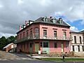
The Braidwood Hotel, which was established in 1859
-
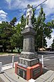
The Braidwood District Soldiers' Memorial
