Araluen, New South Wales facts for kids
Quick facts for kids AraluenNew South Wales |
|||||||||||||||
|---|---|---|---|---|---|---|---|---|---|---|---|---|---|---|---|
 |
|||||||||||||||
| Population | 209 (2021 census) | ||||||||||||||
| Postcode(s) | 2622 | ||||||||||||||
| Elevation | 160 m (525 ft) | ||||||||||||||
| Location | |||||||||||||||
| LGA(s) | Queanbeyan-Palerang Regional Council | ||||||||||||||
| County | St Vincent | ||||||||||||||
| Parish | Araluen | ||||||||||||||
| State electorate(s) | Monaro | ||||||||||||||
| Federal Division(s) | Eden-Monaro | ||||||||||||||
|
|||||||||||||||
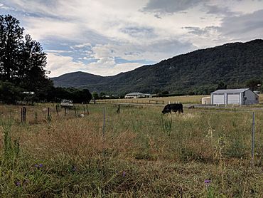
Araluen is a small town in New South Wales, Australia. It is located near Braidwood in the Southern Tablelands region. The town sits in the valley of Araluen Creek, which flows into the Deua River. In 2021, Araluen had a population of 209 people. It is part of the Queanbeyan-Palerang Regional Council.
Contents
What Does Araluen Mean?
The land where Araluen is located traditionally belongs to the Walbanga people. They are a group of the Yuin Aboriginal people. The name 'Araluen' comes from their local language. It means 'water lily' or 'place of the water lilies'.
Gold Rush History
When Europeans first settled here, Araluen Valley was full of natural billabongs (small lakes) with water lilies. Sadly, these billabongs are not there today. The landscape of Araluen Creek changed a lot because of gold mining.
Gold Discovery and Mining Methods
Gold was found in Araluen Creek around 1852. This led to a big 'gold rush'. Many people came to the area, and several mining villages grew. Miners used a method called alluvial gold mining. This means they looked for gold in riverbeds and loose soil. This type of mining changed the valley's natural look.
Floods and Population Changes
Araluen's population grew a lot during the gold rush. However, a major flash flood in 1860 caused a lot of damage. It destroyed much of the town and 24 people died. After this, the population went down. Another flash flood happened in March 2012, which sadly killed one person.
Impact on the Landscape
An account from 1874 described how mining changed the area. It mentioned that the forests were affected, and mining channels crossed the land everywhere. The ground was turned over, making the area look different. The Araluen Creek valley is about 1,200 feet above sea level. It is surrounded by mountains that are about 1,000 feet high. The gold was found in a layer of "wash-dirt" that was between four and thirty feet deep.
Later Mining and Peach Farming
Gold mining saw a return in the early 1900s. Large machines called gold dredges were used. These machines dug up the riverbed to find gold, which added to the changes in the landscape. By the mid-1920s, this type of mining stopped. Over the years, Araluen produced a huge amount of gold, worth more than £11,000,000.
After the gold mining era, Araluen became famous for its delicious stone fruit, especially its large, tasty peaches.
Town Facilities and Nature
Araluen had several schools over the years. Araluen West Public School operated from 1867 to 1919. Araluen Upper Public School was open from 1872 to 1888. Araluen Lower Provisional School operated from 1943 to 1956. There were also evening schools for adults.
Roads and Transport
From its early days, Araluen was connected by road to Braidwood. People traveling from the coast would go through Braidwood. Around 1858, packhorses were used to bring supplies from the coastal town of Moruya. A road, called Araluen Road, was built from Araluen to Moruya between 1867 and 1868.
Unique Plants
Two rare plants grow in the Araluen area. They are the Araluen gum (Eucalyptus kartzoffiana) and the Araluen zieria (Zieria adenophora).
Famous Residents
- Torrington Blatchford (1871–1938): An Australian geologist who was born in Araluen.
- Jackie French (1953–): A well-known Australian author who lives in Araluen.
 | William Lucy |
 | Charles Hayes |
 | Cleveland Robinson |


