Holme Circle, Philadelphia facts for kids
Quick facts for kids
Holme Circle
|
|
|---|---|

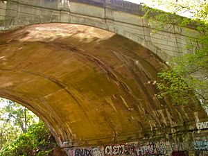
Holme Ave Bridge Crossing Pennypack Creek
|
|
| Country | |
| State | Pennsylvania |
| County | Philadelphia County |
| City | Philadelphia |
| Area code(s) | 215, 267, and 445 |
Holme Circle is a friendly neighborhood located in Northeast Philadelphia, Pennsylvania, United States. It's nestled in a cool loop of the Pennypack Creek, right where Holme Avenue meets Welsh Road. This area is named after Thomas Holme, an important person from the past.
Contents
Exploring Holme Circle
Holme Circle is known for its different types of homes. If you head north of the main circle, you'll find two-story twin homes. These were built between 1959 and 1964. Streets like Walnut Hill, Axe Factory, and Manchester are good examples.
Homes in the Area
Southeast of the circle, there are one-story twin homes. These were built around 1962. You can see them on streets such as Colfax, Draper, and Albion. South of Welsh Road and Holme Avenue, you'll find single homes. This area is called Winchester Park. These houses were built a bit earlier, from 1951 to 1955. Streets like Stamford, Hargrave, Lenola, and Martindale are part of this section.
Learning and Community
The community in Holme Circle has its own local spots. For example, the St Jerome Parish serves the people living here. Kids in the neighborhood go to the Robert B. Pollock Elementary School. This school is located at Welsh Road and Tolbut Street. It's a key part of the local community.
Famous Faces from Holme Circle
Did you know that some famous people have lived in Holme Circle? One well-known former resident is Sylvester Stallone. He's a famous actor and filmmaker. He used to live on Mower Street in the neighborhood. It's pretty cool to think a movie star once called Holme Circle home!
 | Sharif Bey |
 | Hale Woodruff |
 | Richmond Barthé |
 | Purvis Young |

